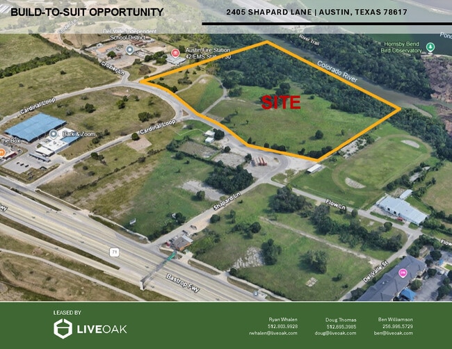
Property Record
2430 Cardinal Loop, Del Valle, TX 78617

Current Lease Availabilities
Property Detail
2430 Cardinal Loop
Austin-Round Rock-San Marcos, TX
ABS 24 DELVALLE S ACR 20.10
446029
TRAVIS
Farms
Texas
AE The base floodplain where base flood elevations are provided. AE Zones are now used on new format FIRMs instead of A1-A30 Zones.
20.10 AC
0
Southeast
2025
Austin
002310
NEARBY LISTINGS FOR SALE OR LEASE
DEMOGRAPHICS near 2430 Cardinal Loop
1 mile
3 mile
5 mile
2024 Total Population
1,578
19,730
111,748
2029 Population
1,671
21,212
118,536
Pop Growth 2024-2029
+ 5.89%
+ 7.51%
+ 6.07%
Average Age
35
35
35
2024 Total Households
495
6,580
43,174
HH Growth 2024-2029
+ 6.67%
+ 8.34%
+ 6.64%
Median Household Inc
$50,460
$76,395
$80,697
Avg Household Size
3.00
2.90
2.50
2024 Avg HH Vehicles
2.00
2.00
2.00
Median Home Value
$159,374
$330,480
$398,095
Median Year Built
1995
2008
2004
Nearby Places
Map Layers
Map Styles
 Street
 Aerial
Transit
 Traffic
 Biking
Places
Listings with unknown addresses are not visible on the map
- Restaurants
- Banks
- Shops
- Fitness
- Groceries
PUBLIC TRANSPORTATION
COMMUTER RAIL
Austin (Texas Eagle - Amtrak)
Drive
Walk
Distance
Austin (Texas Eagle - Amtrak)
15 min
8.5 mi
AIRPORT
Austin-Bergstrom International
Drive
Walk
Distance
Austin-Bergstrom International
17 min
7.3 mi
Freight Ports
Calhoun Port
Drive
Walk
Distance
Calhoun Port
179 min
151.6 mi
Nearby Properties
Address
Land Use
TOTAL SIZE
Lot Size
Zoning
Address
Land Use
TOTAL SIZE
Lot Size
Zoning
942.08 AC
Address
Land Use
TOTAL SIZE
Lot Size
Zoning
255,483 SF
35 AC
Address
Land Use
TOTAL SIZE
Lot Size
Zoning
354,664 SF
16.80 AC
Address
Land Use
TOTAL SIZE
Lot Size
Zoning
206,608 SF
10.61 AC
Address
Land Use
TOTAL SIZE
Lot Size
Zoning
278,730 SF
19.78 AC
Address
Land Use
TOTAL SIZE
Lot Size
Zoning
262,576 SF
15.68 AC
Address
Land Use
TOTAL SIZE
Lot Size
Zoning
179,800 SF
442.94 AC
Address
Land Use
TOTAL SIZE
Lot Size
Zoning
162,000 SF
12.62 AC
Address
Land Use
TOTAL SIZE
Lot Size
Zoning
345,600 SF
49.73 AC
Address
Land Use
TOTAL SIZE
Lot Size
Zoning
214,303 SF
11.32 AC
Address
Land Use
TOTAL SIZE
Lot Size
Zoning
257,600 SF
26.83 AC
Address
Land Use
TOTAL SIZE
Lot Size
Zoning
221,646 SF
6.71 AC
Address
Land Use
TOTAL SIZE
Lot Size
Zoning
172,800 SF
22.82 AC
Address
Land Use
TOTAL SIZE
Lot Size
Zoning
348,838 SF
4.16 AC
Address
Land Use
TOTAL SIZE
Lot Size
Zoning
309,375 SF
18.04 AC
Address
Land Use
TOTAL SIZE
Lot Size
Zoning
295,980 SF
47.98 AC
Address
Land Use
TOTAL SIZE
Lot Size
Zoning
96,050 SF
9.36 AC
Address
Land Use
TOTAL SIZE
Lot Size
Zoning
195,168 SF
9.94 AC
Address
Land Use
TOTAL SIZE
Lot Size
Zoning
139,750 SF
50.37 AC
Address
Land Use
TOTAL SIZE
Lot Size
Zoning
122,836 SF
10.79 AC
Address
Land Use
TOTAL SIZE
Lot Size
Zoning
150,000 SF
16.18 AC
Address
Land Use
TOTAL SIZE
Lot Size
Zoning
231,888 SF
11.86 AC
Address
Land Use
TOTAL SIZE
Lot Size
Zoning
138,850 SF
14.09 AC
Address
Land Use
TOTAL SIZE
Lot Size
Zoning
203,235 SF
19.48 AC
Address
Land Use
TOTAL SIZE
Lot Size
Zoning
88,030 SF
9.72 AC
Address
Land Use
TOTAL SIZE
Lot Size
Zoning
183,082 SF
Address
Land Use
TOTAL SIZE
Lot Size
Zoning
112,101 SF
5.99 AC
Address
Land Use
TOTAL SIZE
Lot Size
Zoning
2,366 SF
19.82 AC
Address
Land Use
TOTAL SIZE
Lot Size
Zoning
72,000 SF
6.05 AC
Address
Land Use
TOTAL SIZE
Lot Size
Zoning
94,952 SF
11.60 AC
The World's #1 Commercial Real Estate Marketplace
Connect with us
© 2026 CoStar Group
The information above has been obtained from sources believed reliable. While we do not doubt its accuracy we have not verified it and make no guarantee, warranty or representation about it. It is your responsibility to independently confirm its accuracy and completeness. Any projections, opinions, assumptions, or estimates used are for example only and do not represent the current or future performance of the property. The value of this transaction to you depends on tax and other factors which should be evaluated by your tax, financial, and legal advisors. You and your advisors should conduct a careful, independent investigation of the property to determine to your satisfaction the suitability of the property for your needs.