Property Record
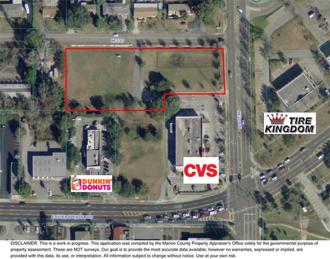
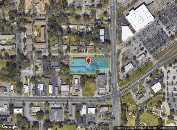
2430 Ne 2Nd St, Ocala, FL 34470
NEARBY LISTINGS FOR SALE OR LEASE
Property Detail
2430 Ne 2Nd St
Ocala, FL
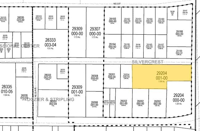
Silvercrest
29204-001-00
SEC 16 TWP 15 RGE 22 PLAT BOOK C PAGE 076 SILVERCREST BLK 2 LOTS 1.3.4.5 & N 33 FT OF LOT 2
Motel
Marion
X
Florida
12083C0528E
1
2024
1.87 AC
2024
Greater Ocala
002001
Ocala
23,088 SF
DEMOGRAPHICS near 2430 Ne 2Nd St
1 Mile
3 Mile
5 Mile
2024 Total Population
7,888
52,511
100,540
2029 Population
8,839
59,005
113,308
Pop Growth 2024-2029
+ 12.06%
+ 12.37%
+ 12.70%
Average Age
38
41
41
2024 Total Households
3,385
21,572
40,360
HH Growth 2024-2029
+ 12.05%
+ 12.34%
+ 12.74%
Median Household Inc
$43,845
$54,815
$54,554
Avg Household Size
2.30
2.40
2.40
2024 Avg HH Vehicles
2.00
2.00
2.00
Median Home Value
$174,741
$184,687
$187,242
Median Year Built
1971
1978
1983
Nearby Places
Map Layers
Map Styles
 Street
 Aerial
- Restaurants
- Banks
- Shops
- Fitness
- Groceries
SALE & LEASE HISTORY
LISTING DATE
SALE/LEASE

Mar 27, 2017
For Sale
Nearby Properties
Address
Land Use
TOTAL SIZE
Lot Size
Zoning
Address
Land Use
TOTAL SIZE
Lot Size
Zoning
207,950 SF
14.08 AC
INST
Address
Land Use
TOTAL SIZE
Lot Size
Zoning
326,425 SF
11.66 AC
INST
Address
Land Use
TOTAL SIZE
Lot Size
Zoning
189,286 SF
35.42 AC
PD08
Address
Land Use
TOTAL SIZE
Lot Size
Zoning
195,992 SF
5.72 AC
FBC
Address
Land Use
TOTAL SIZE
Lot Size
Zoning
88,462 SF
31.76 AC
INST
Address
Land Use
TOTAL SIZE
Lot Size
Zoning
89,426 SF
15.16 AC
PD12
Address
Land Use
TOTAL SIZE
Lot Size
Zoning
116,035 SF
38.20 AC
GU
Address
Land Use
TOTAL SIZE
Lot Size
Zoning
5,815 SF
186.33 AC
GU
Address
Land Use
TOTAL SIZE
Lot Size
Zoning
56,484 SF
12.50 AC
PD14
Address
Land Use
TOTAL SIZE
Lot Size
Zoning
101,892 SF
16.81 AC
INST
Address
Land Use
TOTAL SIZE
Lot Size
Zoning
180,334 SF
24.29 AC
INST
Address
Land Use
TOTAL SIZE
Lot Size
Zoning
111,395 SF
13 AC
B2
Address
Land Use
TOTAL SIZE
Lot Size
Zoning
30,334 SF
29.72 AC
GU
Address
Land Use
TOTAL SIZE
Lot Size
Zoning
78,280 SF
12.54 AC
R3
Address
Land Use
TOTAL SIZE
Lot Size
Zoning
40,150 SF
11.31 AC
SC
Address
Land Use
TOTAL SIZE
Lot Size
Zoning
196,416 SF
29.65 AC
SC
Address
Land Use
TOTAL SIZE
Lot Size
Zoning
19,117 SF
0.98 AC
FBC
Address
Land Use
TOTAL SIZE
Lot Size
Zoning
71,065 SF
12.01 AC
B2
Address
Land Use
TOTAL SIZE
Lot Size
Zoning
132,214 SF
40 AC
GU
Address
Land Use
TOTAL SIZE
Lot Size
Zoning
134,827 SF
14.83 AC
SC
Address
Land Use
TOTAL SIZE
Lot Size
Zoning
26,801 SF
5.66 AC
FBC
Address
Land Use
TOTAL SIZE
Lot Size
Zoning
49,963 SF
9.84 AC
PD14
Address
Land Use
TOTAL SIZE
Lot Size
Zoning
192,553 SF
21.18 AC
SC
Address
Land Use
TOTAL SIZE
Lot Size
Zoning
121,462 SF
10.92 AC
B2
Address
Land Use
TOTAL SIZE
Lot Size
Zoning
107,613 SF
66.76 AC
GU
Address
Land Use
TOTAL SIZE
Lot Size
Zoning
40,049 SF
1.06 AC
FBC
Address
Land Use
TOTAL SIZE
Lot Size
Zoning
134,890 SF
18.90 AC
B4
Address
Land Use
TOTAL SIZE
Lot Size
Zoning
50,199 SF
4.74 AC
FBC
Address
Land Use
TOTAL SIZE
Lot Size
Zoning
58,040 SF
10.24 AC
INST
Address
Land Use
TOTAL SIZE
Lot Size
Zoning
80,571 SF
13.72 AC
INST
The World's #1 Commercial Real Estate Marketplace
Connect with us
© 2025 CoStar Group
The information above has been obtained from sources believed reliable. While we do not doubt its accuracy we have not verified it and make no guarantee, warranty or representation about it. It is your responsibility to independently confirm its accuracy and completeness. Any projections, opinions, assumptions, or estimates used are for example only and do not represent the current or future performance of the property. The value of this transaction to you depends on tax and other factors which should be evaluated by your tax, financial, and legal advisors. You and your advisors should conduct a careful, independent investigation of the property to determine to your satisfaction the suitability of the property for your needs.