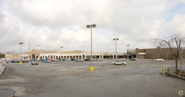
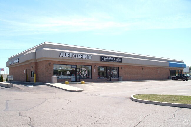
Property Record
2430 Stringtown Rd, Grove City, OH 43123

NEARBY LISTINGS FOR SALE OR LEASE
Property Detail
2430 Stringtown Rd
040-002135
Virginia Military Survey No 8231
Supermarket
000 STRINGTOWN ROAD ENTRY 8231-6839 7.8729 ACRES
AE
Franklin
39049C0314K
Ohio
2024
7.87 AC
2024
Southwest
009756
Columbus
89,902 SF
Columbus, OH
DEMOGRAPHICS near 2430 Stringtown Rd
1 Mile
3 Mile
5 Mile
2024 Total Population
11,493
62,950
155,787
2029 Population
11,477
63,080
156,388
Pop Growth 2024-2029
(0.14%)
+ 0.21%
+ 0.39%
Average Age
41
40
38
2024 Total Households
4,854
24,181
58,591
HH Growth 2024-2029
(0.06%)
+ 0.24%
+ 0.30%
Median Household Inc
$67,442
$79,603
$64,511
Avg Household Size
2.30
2.50
2.50
2024 Avg HH Vehicles
2.00
2.00
2.00
Median Home Value
$189,980
$227,015
$191,429
Median Year Built
1973
1992
1977
Nearby Places
Map Layers
Map Styles
 Street
 Aerial
- Restaurants
- Banks
- Shops
- Fitness
- Groceries
PUBLIC TRANSPORTATION
AIRPORT
Rickenbacker International
DRIVE
WALK
Distance
Rickenbacker International
20 min
12.1 mi
John Glenn Columbus International
DRIVE
WALK
Distance
John Glenn Columbus International
25 min
15.9 mi
Freight Ports
Port of Toledo
DRIVE
WALK
Distance
Port of Toledo
193 min
142.7 mi
Nearby Properties
Address
Land Use
TOTAL SIZE
Lot Size
Zoning
Address
Land Use
TOTAL SIZE
Lot Size
Zoning
844,679 SF
61.71 AC
Address
Land Use
TOTAL SIZE
Lot Size
Zoning
1,058 SF
0.03 AC
Address
Land Use
TOTAL SIZE
Lot Size
Zoning
470,659 SF
101.09 AC
Address
Land Use
TOTAL SIZE
Lot Size
Zoning
210,724 SF
43.38 AC
Address
Land Use
TOTAL SIZE
Lot Size
Zoning
125,467 SF
20.61 AC
Address
Land Use
TOTAL SIZE
Lot Size
Zoning
928,228 SF
39.80 AC
Address
Land Use
TOTAL SIZE
Lot Size
Zoning
1,178,014 SF
152.63 AC
Address
Land Use
TOTAL SIZE
Lot Size
Zoning
170,028 SF
13.66 AC
Address
Land Use
TOTAL SIZE
Lot Size
Zoning
749,152 SF
41.23 AC
Address
Land Use
TOTAL SIZE
Lot Size
Zoning
128,263 SF
6.59 AC
Address
Land Use
TOTAL SIZE
Lot Size
Zoning
169,252 SF
22.06 AC
Address
Land Use
TOTAL SIZE
Lot Size
Zoning
227,844 SF
21.57 AC
Address
Land Use
TOTAL SIZE
Lot Size
Zoning
110,590 SF
13.44 AC
Address
Land Use
TOTAL SIZE
Lot Size
Zoning
493,000 SF
29.55 AC
Address
Land Use
TOTAL SIZE
Lot Size
Zoning
46,692 SF
22.40 AC
Address
Land Use
TOTAL SIZE
Lot Size
Zoning
122,159 SF
2.77 AC
Address
Land Use
TOTAL SIZE
Lot Size
Zoning
322,000 SF
22.14 AC
Address
Land Use
TOTAL SIZE
Lot Size
Zoning
408,294 SF
26.64 AC
Address
Land Use
TOTAL SIZE
Lot Size
Zoning
322,000 SF
18.83 AC
Address
Land Use
TOTAL SIZE
Lot Size
Zoning
542,043 SF
30.41 AC
Address
Land Use
TOTAL SIZE
Lot Size
Zoning
404,812 SF
41.33 AC
Address
Land Use
TOTAL SIZE
Lot Size
Zoning
227,576 SF
52.33 AC
Address
Land Use
TOTAL SIZE
Lot Size
Zoning
377,124 SF
19.58 AC
Address
Land Use
TOTAL SIZE
Lot Size
Zoning
399,784 SF
20.86 AC
Address
Land Use
TOTAL SIZE
Lot Size
Zoning
60,893 SF
19.92 AC
Address
Land Use
TOTAL SIZE
Lot Size
Zoning
137,488 SF
13.44 AC
Address
Land Use
TOTAL SIZE
Lot Size
Zoning
227,826 SF
15.68 AC
Address
Land Use
TOTAL SIZE
Lot Size
Zoning
132,379 SF
15.46 AC
Address
Land Use
TOTAL SIZE
Lot Size
Zoning
61,595 SF
9.75 AC
Address
Land Use
TOTAL SIZE
Lot Size
Zoning
36,877 SF
21.13 AC
The World's #1 Commercial Real Estate Marketplace
Connect with us
© 2025 CoStar Group
The information above has been obtained from sources believed reliable. While we do not doubt its accuracy we have not verified it and make no guarantee, warranty or representation about it. It is your responsibility to independently confirm its accuracy and completeness. Any projections, opinions, assumptions, or estimates used are for example only and do not represent the current or future performance of the property. The value of this transaction to you depends on tax and other factors which should be evaluated by your tax, financial, and legal advisors. You and your advisors should conduct a careful, independent investigation of the property to determine to your satisfaction the suitability of the property for your needs.