Property Record
2431 Osborne Rd, Saint Marys, GA 31558
NEARBY LISTINGS FOR SALE OR LEASE
-
-
View all Saint Marys listings for sale on LoopNet.com
Property Detail
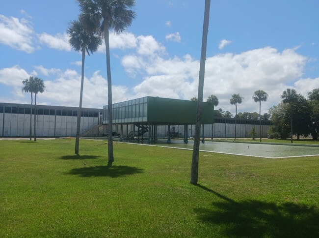
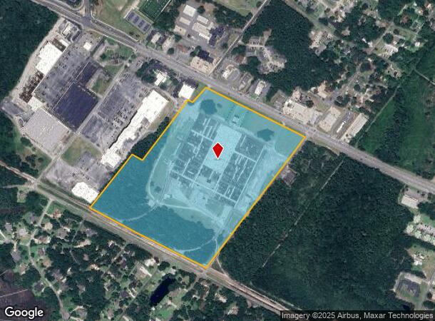
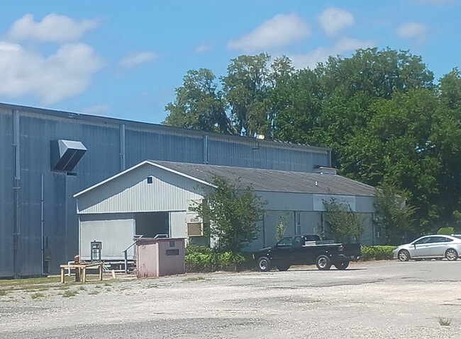
2431 Osborne Rd
St. Marys, GA
Kingsland/St Marys Hwy 40 Ac
135-087
COMM (PLANT)/L S/S OSBORNE RD
Industrialgeneral
Camden
2025
Georgia
2025
40.62 AC
010603
Brunswick/Kingsland
451,960 SF
Other Market Areas
DEMOGRAPHICS near 2431 Osborne Rd
1 Mile
3 Mile
5 Mile
2024 Total Population
2,615
15,333
26,538
2029 Population
2,847
16,690
29,071
Pop Growth 2024-2029
+ 8.87%
+ 8.85%
+ 9.54%
Average Age
40
39
37
2024 Total Households
1,062
6,202
9,591
HH Growth 2024-2029
+ 8.95%
+ 9.08%
+ 9.84%
Median Household Inc
$51,176
$65,233
$69,679
Avg Household Size
2.30
2.40
2.50
2024 Avg HH Vehicles
2.00
2.00
2.00
Median Home Value
$279,838
$254,698
$253,515
Median Year Built
1985
1993
1994
Nearby Places
- Restaurants
- Banks
- Shops
- Fitness
- Groceries
PUBLIC TRANSPORTATION
AIRPORT
Jacksonville International
DRIVE
WALK
Distance
Jacksonville International
41 min
29.2 mi
Freight Ports
Georgia Ports - Brunswick
DRIVE
WALK
Distance
Georgia Ports - Brunswick
48 min
36.2 mi
SALE & LEASE HISTORY
LISTING DATE
SALE/LEASE

Sep 25, 2016
For Lease
May 07, 2024
For Sale
Nearby Properties
Address
Land Use
TOTAL SIZE
Lot Size
Zoning
Address
Land Use
TOTAL SIZE
Lot Size
Zoning
172,807 SF
45.10 AC
R-1
Address
Land Use
TOTAL SIZE
Lot Size
Zoning
115,682 SF
4 AC
C-1
Address
Land Use
TOTAL SIZE
Lot Size
Zoning
1,456 SF
15.71 AC
R-3
Address
Land Use
TOTAL SIZE
Lot Size
Zoning
80,350 SF
28 AC
PD
Address
Land Use
TOTAL SIZE
Lot Size
Zoning
14,152 SF
14.25 AC
R-3
Address
Land Use
TOTAL SIZE
Lot Size
Zoning
9,744 SF
13.84 AC
R-3
Address
Land Use
TOTAL SIZE
Lot Size
Zoning
1,143 AC
PD M-U
Address
Land Use
TOTAL SIZE
Lot Size
Zoning
28,858 SF
5.09 AC
R-3
Address
Land Use
TOTAL SIZE
Lot Size
Zoning
3,240 SF
13.97 AC
R-1
Address
Land Use
TOTAL SIZE
Lot Size
Zoning
2.61 AC
C-1
Address
Land Use
TOTAL SIZE
Lot Size
Zoning
77,912 SF
12.76 AC
C-2
Address
Land Use
TOTAL SIZE
Lot Size
Zoning
11,086 SF
6.26 AC
R-3
Address
Land Use
TOTAL SIZE
Lot Size
Zoning
4,906 SF
0.87 AC
C-1
Address
Land Use
TOTAL SIZE
Lot Size
Zoning
54,408 SF
15.57 AC
I-A
Address
Land Use
TOTAL SIZE
Lot Size
Zoning
6,720 SF
25 AC
R-3
Address
Land Use
TOTAL SIZE
Lot Size
Zoning
18,025 SF
12.47 AC
C-2
Address
Land Use
TOTAL SIZE
Lot Size
Zoning
0.46 AC
C-1
Address
Land Use
TOTAL SIZE
Lot Size
Zoning
92,858 SF
10.67 AC
C-2
Address
Land Use
TOTAL SIZE
Lot Size
Zoning
12,560 SF
4.93 AC
C-2
Address
Land Use
TOTAL SIZE
Lot Size
Zoning
31,040 SF
4.48 AC
I-L
Address
Land Use
TOTAL SIZE
Lot Size
Zoning
2,220 SF
3.64 AC
I-L
Address
Land Use
TOTAL SIZE
Lot Size
Zoning
12,656 SF
7.02 AC
R-3
Address
Land Use
TOTAL SIZE
Lot Size
Zoning
12,396 SF
0.34 AC
C-1
Address
Land Use
TOTAL SIZE
Lot Size
Zoning
4,052 SF
218.60 AC
I-A
Address
Land Use
TOTAL SIZE
Lot Size
Zoning
33,000 SF
3.17 AC
C-2
Address
Land Use
TOTAL SIZE
Lot Size
Zoning
1,742 SF
0.40 AC
C-1
Address
Land Use
TOTAL SIZE
Lot Size
Zoning
1,724 SF
210.86 AC
PD CP
Address
Land Use
TOTAL SIZE
Lot Size
Zoning
49,031 SF
5.29 AC
C-2
Address
Land Use
TOTAL SIZE
Lot Size
Zoning
6,868 SF
2.30 AC
C-2
The World's #1 Commercial Real Estate Marketplace
Connect with us
© 2025 CoStar Group
The information above has been obtained from sources believed reliable. While we do not doubt its accuracy we have not verified it and make no guarantee, warranty or representation about it. It is your responsibility to independently confirm its accuracy and completeness. Any projections, opinions, assumptions, or estimates used are for example only and do not represent the current or future performance of the property. The value of this transaction to you depends on tax and other factors which should be evaluated by your tax, financial, and legal advisors. You and your advisors should conduct a careful, independent investigation of the property to determine to your satisfaction the suitability of the property for your needs.