Property Record
24328 Marrwood Dr, Aldie, VA 20105


NEARBY LISTINGS FOR SALE OR LEASE
-
-
View all Aldie listings for lease on LoopNet.com
Property Detail
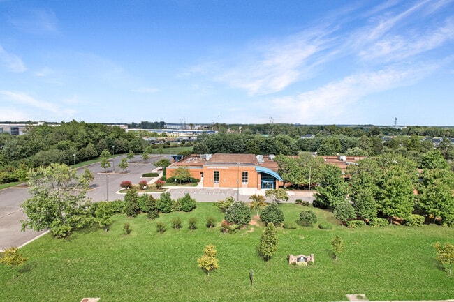
24328 Marrwood Dr
246-19-7273
Arcola Elementary School
Publichealthcarefacility
ARCOLA ELEMENTARY SCHOOL 200804300026016 200910150069933P
X
Loudoun
51107C0355E
Virginia
2025
14.63 AC
2025
Leesburg/West Loudoun
611809
Washington, DC
44,384 SF
Washington-Arlington-Alexandria, DC-VA-MD-WV
DEMOGRAPHICS near 24328 Marrwood Dr
1 Mile
3 Mile
5 Mile
2024 Total Population
7,334
67,641
124,909
2029 Population
7,991
73,505
135,150
Pop Growth 2024-2029
+ 8.96%
+ 8.67%
+ 8.20%
Average Age
34
34
34
2024 Total Households
2,185
20,033
37,423
HH Growth 2024-2029
+ 8.83%
+ 8.82%
+ 8.31%
Median Household Inc
$187,803
$190,326
$190,377
Avg Household Size
3.40
3.40
3.30
2024 Avg HH Vehicles
2.00
2.00
2.00
Median Home Value
$727,076
$755,291
$739,976
Median Year Built
2011
2010
2010
Nearby Places
Map Layers
Map Styles
 Street
 Aerial
- Restaurants
- Banks
- Shops
- Fitness
- Groceries
PUBLIC TRANSPORTATION
AIRPORT
Washington Dulles International
DRIVE
WALK
Distance
Washington Dulles International
20 min
13.6 mi
Ronald Reagan Washington Ntl
DRIVE
WALK
Distance
Ronald Reagan Washington Ntl
53 min
34.4 mi
Freight Ports
Port of Baltimore
DRIVE
WALK
Distance
Port of Baltimore
1 min
56.3 mi
SALE & LEASE HISTORY
LISTING DATE
SALE/LEASE

Oct 29, 2018
For Sale
Oct 29, 2018
For Lease
Feb 25, 2019
For Sale
Aug 28, 2024
For Lease
Aug 26, 2024
For Sale
Nearby Properties
Address
Land Use
TOTAL SIZE
Lot Size
Zoning
Address
Land Use
TOTAL SIZE
Lot Size
Zoning
669,358 SF
39.88 AC
IP
Address
Land Use
TOTAL SIZE
Lot Size
Zoning
538,565 SF
135.31 AC
PDIP
Address
Land Use
TOTAL SIZE
Lot Size
Zoning
695,321 SF
63.54 AC
PDGI
Address
Land Use
TOTAL SIZE
Lot Size
Zoning
204,014 SF
23.47 AC
PDIP
Address
Land Use
TOTAL SIZE
Lot Size
Zoning
252,600 SF
33.26 AC
PDIP
Address
Land Use
TOTAL SIZE
Lot Size
Zoning
759,405 SF
64.76 AC
IP
Address
Land Use
TOTAL SIZE
Lot Size
Zoning
49.36 AC
IP
Address
Land Use
TOTAL SIZE
Lot Size
Zoning
536,602 SF
117.49 AC
TR3UBF
Address
Land Use
TOTAL SIZE
Lot Size
Zoning
415,477 SF
97.76 AC
TR1UBF
Address
Land Use
TOTAL SIZE
Lot Size
Zoning
222,313 SF
36.21 AC
PDOP
Address
Land Use
TOTAL SIZE
Lot Size
Zoning
422,597 SF
85.43 AC
TR3UBF
Address
Land Use
TOTAL SIZE
Lot Size
Zoning
48.30 AC
PDIP
Address
Land Use
TOTAL SIZE
Lot Size
Zoning
59.20 AC
IP
Address
Land Use
TOTAL SIZE
Lot Size
Zoning
181,718 SF
10.23 AC
R16
Address
Land Use
TOTAL SIZE
Lot Size
Zoning
303,168 SF
41.95 AC
PDCCRC
Address
Land Use
TOTAL SIZE
Lot Size
Zoning
264,902 SF
60.25 AC
PDH4
Address
Land Use
TOTAL SIZE
Lot Size
Zoning
54 AC
PDTC
Address
Land Use
TOTAL SIZE
Lot Size
Zoning
192,413 SF
30.38 AC
TR3UBF
Address
Land Use
TOTAL SIZE
Lot Size
Zoning
234,264 SF
66.14 AC
PDGI
Address
Land Use
TOTAL SIZE
Lot Size
Zoning
1,848 SF
21.23 AC
PDIP
Address
Land Use
TOTAL SIZE
Lot Size
Zoning
107,378 SF
16.86 AC
PDH4
Address
Land Use
TOTAL SIZE
Lot Size
Zoning
169,872 SF
33.51 AC
PDH4
Address
Land Use
TOTAL SIZE
Lot Size
Zoning
72.66 AC
PDAAAR
Address
Land Use
TOTAL SIZE
Lot Size
Zoning
108,231 SF
26.10 AC
PDH4
Address
Land Use
TOTAL SIZE
Lot Size
Zoning
108,037 SF
18.49 AC
PDCCSC
Address
Land Use
TOTAL SIZE
Lot Size
Zoning
241,429 SF
9.03 AC
PDH4
Address
Land Use
TOTAL SIZE
Lot Size
Zoning
20,578 SF
256.12 AC
TR3UBF
The World's #1 Commercial Real Estate Marketplace
Connect with us
© 2026 CoStar Group
The information above has been obtained from sources believed reliable. While we do not doubt its accuracy we have not verified it and make no guarantee, warranty or representation about it. It is your responsibility to independently confirm its accuracy and completeness. Any projections, opinions, assumptions, or estimates used are for example only and do not represent the current or future performance of the property. The value of this transaction to you depends on tax and other factors which should be evaluated by your tax, financial, and legal advisors. You and your advisors should conduct a careful, independent investigation of the property to determine to your satisfaction the suitability of the property for your needs.