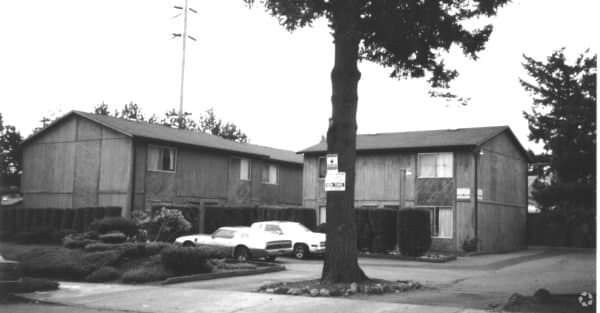
Property Record
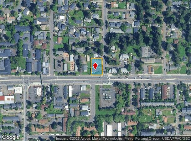
2427 Se 139Th Ave, Portland, OR 97233
NEARBY LISTINGS FOR SALE OR LEASE
Property Detail
2427 Se 139Th Ave
Portland-Vancouver-Hillsboro, OR-WA
Hood Acres & Plat 2 & 3
R183914
HOOD ACRES & PLAT 2 & 3, BLOCK 11, LOT 18, EXC N 40 & EXC PT IN ST
Quadruplex
Multnomah
ARE
Oregon
53011C0525D
18
2025
0.32 AC
2025
Gateway
009203
Portland
5,184 SF
DEMOGRAPHICS near 2427 Se 139Th Ave
1 mile
3 mile
5 mile
2024 Total Population
25,894
169,383
368,533
2029 Population
25,165
165,564
361,404
Pop Growth 2024-2029
(2.82%)
(2.25%)
(1.93%)
Average Age
38
40
40
2024 Total Households
8,555
59,670
137,841
HH Growth 2024-2029
(3.18%)
(2.56%)
(2.27%)
Median Household Inc
$55,859
$60,500
$71,422
Avg Household Size
2.80
2.60
2.50
2024 Avg HH Vehicles
2.00
2.00
2.00
Median Home Value
$345,279
$382,243
$433,201
Median Year Built
1972
1974
1972
Nearby Places
Map Layers
Map Styles
 Street
 Aerial
Transit
 Traffic
 Biking
Places
Listings with unknown addresses are not visible on the map
- Restaurants
- Banks
- Shops
- Fitness
- Groceries
PUBLIC TRANSPORTATION
AIRPORT
Portland International
Drive
Walk
Distance
Portland International
19 min
9.7 mi
Freight Ports
Port of Portland
Drive
Walk
Distance
Port of Portland
23 min
13.1 mi
Nearby Properties
Address
Land Use
TOTAL SIZE
Lot Size
Zoning
Address
Land Use
TOTAL SIZE
Lot Size
Zoning
1,024 SF
15.92 AC
OS
Address
Land Use
TOTAL SIZE
Lot Size
Zoning
361,549 SF
39.26 AC
IR
Address
Land Use
TOTAL SIZE
Lot Size
Zoning
250,280 SF
23.86 AC
IR
Address
Land Use
TOTAL SIZE
Lot Size
Zoning
31,878 SF
15.95 AC
IG2
Address
Land Use
TOTAL SIZE
Lot Size
Zoning
260,995 SF
6.49 AC
RTC
Address
Land Use
TOTAL SIZE
Lot Size
Zoning
42,839,055 SF
19.25 AC
CI1
Address
Land Use
TOTAL SIZE
Lot Size
Zoning
109,231 SF
7.87 AC
HI
Address
Land Use
TOTAL SIZE
Lot Size
Zoning
181,493 SF
3.70 AC
CM1
Address
Land Use
TOTAL SIZE
Lot Size
Zoning
123,716 SF
20.03 AC
LDR-5
Address
Land Use
TOTAL SIZE
Lot Size
Zoning
369,835 SF
6.67 AC
IRD
Address
Land Use
TOTAL SIZE
Lot Size
Zoning
99,100 SF
1.31 AC
CS
Address
Land Use
TOTAL SIZE
Lot Size
Zoning
129,462 SF
15.90 AC
R7
Address
Land Use
TOTAL SIZE
Lot Size
Zoning
21,200 SF
16.03 AC
OS
Address
Land Use
TOTAL SIZE
Lot Size
Zoning
258,564 SF
20.56 AC
LDR7
Address
Land Use
TOTAL SIZE
Lot Size
Zoning
53,774 SF
3 AC
Address
Land Use
TOTAL SIZE
Lot Size
Zoning
86,138 SF
5.93 AC
R7
Address
Land Use
TOTAL SIZE
Lot Size
Zoning
105,961 SF
8.76 AC
RM1
Address
Land Use
TOTAL SIZE
Lot Size
Zoning
126,776 SF
5.07 AC
RH
Address
Land Use
TOTAL SIZE
Lot Size
Zoning
82,335 SF
11.34 AC
R5
Address
Land Use
TOTAL SIZE
Lot Size
Zoning
153,648 SF
12.31 AC
CX
Address
Land Use
TOTAL SIZE
Lot Size
Zoning
122,558 SF
9.85 AC
CM2
Address
Land Use
TOTAL SIZE
Lot Size
Zoning
91,064 SF
0.90 AC
RXD
Address
Land Use
TOTAL SIZE
Lot Size
Zoning
121,144 SF
2.30 AC
RM3
Address
Land Use
TOTAL SIZE
Lot Size
Zoning
121,966 SF
1.97 AC
CM
Address
Land Use
TOTAL SIZE
Lot Size
Zoning
154,347 SF
12.35 AC
CE
Address
Land Use
TOTAL SIZE
Lot Size
Zoning
60,000 SF
1.55 AC
RTC
Address
Land Use
TOTAL SIZE
Lot Size
Zoning
62,592 SF
1.47 AC
RM3
Address
Land Use
TOTAL SIZE
Lot Size
Zoning
142,946 SF
Address
Land Use
TOTAL SIZE
Lot Size
Zoning
117,279 SF
9.86 AC
CM3
Address
Land Use
TOTAL SIZE
Lot Size
Zoning
72,925 SF
4.29 AC
CM3
The World's #1 Commercial Real Estate Marketplace
Connect with us
© 2026 CoStar Group
The information above has been obtained from sources believed reliable. While we do not doubt its accuracy we have not verified it and make no guarantee, warranty or representation about it. It is your responsibility to independently confirm its accuracy and completeness. Any projections, opinions, assumptions, or estimates used are for example only and do not represent the current or future performance of the property. The value of this transaction to you depends on tax and other factors which should be evaluated by your tax, financial, and legal advisors. You and your advisors should conduct a careful, independent investigation of the property to determine to your satisfaction the suitability of the property for your needs.