Property Record
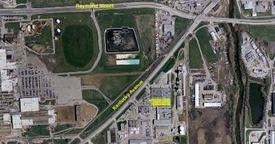
2435 Kentucky Ave, Indianapolis, IN 46221
NEARBY LISTINGS FOR SALE OR LEASE
Property Detail
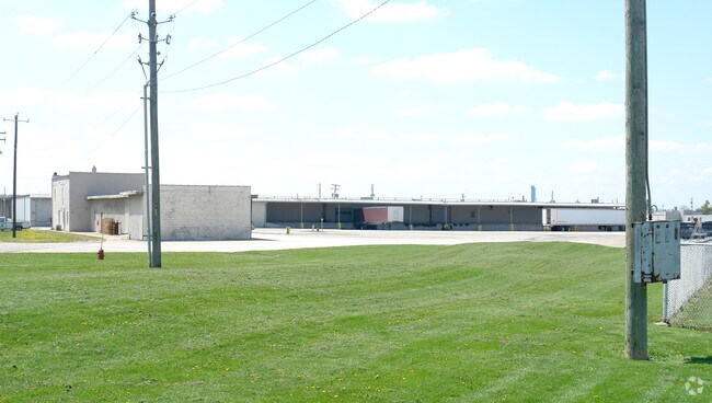
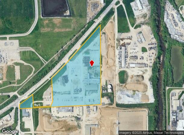
2435 Kentucky Ave
Indianapolis-Carmel-Anderson, IN
PT NE & SE 1/4 S21 T15 R3 627 E OF SW COR P.O.B. NE101 N471 NE574 NE591 S1593 W30 S762 TO CURVE W269 N72 W103 N216 W481 N29 W184 N210 E226 N280 TO POB 40.22 AC.
49-11-21-105-003.000-970
Marion
Warehouse
Indiana
2023
40.22 AC
2024
Stout Field
342400
Indianapolis
132,183 SF
DEMOGRAPHICS near 2435 Kentucky Ave
1 Mile
3 Mile
5 Mile
2024 Total Population
1,231
49,185
207,389
2029 Population
1,253
49,266
207,869
Pop Growth 2024-2029
+ 1.79%
+ 0.16%
+ 0.23%
Average Age
37
36
35
2024 Total Households
424
18,639
85,300
HH Growth 2024-2029
+ 1.65%
+ 0.12%
+ 0.35%
Median Household Inc
$52,604
$48,126
$54,570
Avg Household Size
2.70
2.50
2.30
2024 Avg HH Vehicles
2.00
2.00
2.00
Median Home Value
$67,609
$92,780
$150,410
Median Year Built
1950
1952
1962
Nearby Places
Map Layers
Map Styles
 Street
 Aerial
- Restaurants
- Banks
- Shops
- Fitness
- Groceries
PUBLIC TRANSPORTATION
COMMUTER RAIL
Indianapolis (Cardinal - Amtrak)
DRIVE
WALK
Distance
Indianapolis (Cardinal - Amtrak)
7 min
3.8 mi
AIRPORT
Indianapolis International
DRIVE
WALK
Distance
Indianapolis International
21 min
10.5 mi
Freight Ports
Port of Toledo
DRIVE
WALK
Distance
Port of Toledo
277 min
230.2 mi
Nearby Properties
Address
Land Use
TOTAL SIZE
Lot Size
Zoning
Address
Land Use
TOTAL SIZE
Lot Size
Zoning
33.61 AC
ZO01
Address
Land Use
TOTAL SIZE
Lot Size
Zoning
111,238 SF
0.06 AC
ZO01
Address
Land Use
TOTAL SIZE
Lot Size
Zoning
67,783 SF
44.97 AC
ZO01
Address
Land Use
TOTAL SIZE
Lot Size
Zoning
19.74 AC
ZO01
Address
Land Use
TOTAL SIZE
Lot Size
Zoning
405,888 SF
19.56 AC
ZO01
Address
Land Use
TOTAL SIZE
Lot Size
Zoning
51,801 SF
0.06 AC
ZO01
Address
Land Use
TOTAL SIZE
Lot Size
Zoning
366,600 SF
29.05 AC
ZO01
Address
Land Use
TOTAL SIZE
Lot Size
Zoning
18,232 SF
4.16 AC
ZO01
Address
Land Use
TOTAL SIZE
Lot Size
Zoning
4,663 SF
7.98 AC
ZO01
Address
Land Use
TOTAL SIZE
Lot Size
Zoning
600,000 SF
41.64 AC
ZO01
Address
Land Use
TOTAL SIZE
Lot Size
Zoning
61,832 SF
0.06 AC
ZO01
Address
Land Use
TOTAL SIZE
Lot Size
Zoning
24,798 SF
1.40 AC
ZO01
Address
Land Use
TOTAL SIZE
Lot Size
Zoning
40,128 SF
2.16 AC
ZO01
Address
Land Use
TOTAL SIZE
Lot Size
Zoning
39,751 SF
3.72 AC
ZO01
Address
Land Use
TOTAL SIZE
Lot Size
Zoning
1.88 AC
ZO01
Address
Land Use
TOTAL SIZE
Lot Size
Zoning
101,718 SF
49.77 AC
ZO01
Address
Land Use
TOTAL SIZE
Lot Size
Zoning
595,354 SF
193.41 AC
ZO01
Address
Land Use
TOTAL SIZE
Lot Size
Zoning
378,039 SF
0.06 AC
ZO01
Address
Land Use
TOTAL SIZE
Lot Size
Zoning
20,143 SF
17.10 AC
ZO01
Address
Land Use
TOTAL SIZE
Lot Size
Zoning
19,037 SF
0.72 AC
ZO01
Address
Land Use
TOTAL SIZE
Lot Size
Zoning
537,085 SF
111.99 AC
ZO01
Address
Land Use
TOTAL SIZE
Lot Size
Zoning
438,419 SF
17.26 AC
ZO01
Address
Land Use
TOTAL SIZE
Lot Size
Zoning
150,376 SF
7.30 AC
ZO01
Address
Land Use
TOTAL SIZE
Lot Size
Zoning
113,213 SF
0.06 AC
ZO01
Address
Land Use
TOTAL SIZE
Lot Size
Zoning
73,919 SF
2.58 AC
ZO01
Address
Land Use
TOTAL SIZE
Lot Size
Zoning
5,000 SF
0.44 AC
ZO01
Address
Land Use
TOTAL SIZE
Lot Size
Zoning
75,012 SF
0.06 AC
ZO01
Address
Land Use
TOTAL SIZE
Lot Size
Zoning
290,347 SF
30.40 AC
ZO01
Address
Land Use
TOTAL SIZE
Lot Size
Zoning
18,209 SF
38.23 AC
ZO01
Address
Land Use
TOTAL SIZE
Lot Size
Zoning
0.42 AC
ZO01
The World's #1 Commercial Real Estate Marketplace
Connect with us
© 2025 CoStar Group
The information above has been obtained from sources believed reliable. While we do not doubt its accuracy we have not verified it and make no guarantee, warranty or representation about it. It is your responsibility to independently confirm its accuracy and completeness. Any projections, opinions, assumptions, or estimates used are for example only and do not represent the current or future performance of the property. The value of this transaction to you depends on tax and other factors which should be evaluated by your tax, financial, and legal advisors. You and your advisors should conduct a careful, independent investigation of the property to determine to your satisfaction the suitability of the property for your needs.