Property Record
24352 State Road 44, Eustis, FL 32736
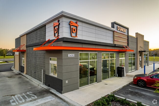

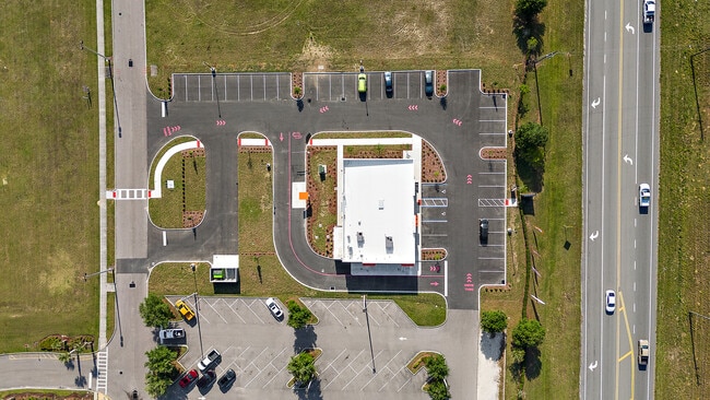
Property Detail
24352 State Road 44
12-19-27-1900-00C-00002
SORRENTO HILLS PHASES 1 & 2 PB 48 PG 4-15 FROM NW COR OF NE 1/4 OF SEC 18-19-28 RUN N 01-11-20 E ALONG E LINE OF SW 1/4 OF SEC 7 A DIST OF 2563.53 FT S 89-09-03 W ALONG N LINE OF TRACT C & E'LY PROJECTION THEREOF & S R/W LINE OF SR 44 A DIST OF 919.3
Stripcommercialcenter
LAKE
B and X Area of moderate flood hazard, usually the area between the limits of the 100-year and 500-year floods.
Florida
2025
1.20 AC
2026
Lake County
030917
Orlando
4,028 SF
Orlando-Kissimmee-Sanford, FL
NEARBY LISTINGS FOR SALE OR LEASE
-
-
View all Eustis listings for sale on LoopNet.com
DEMOGRAPHICS near 24352 State Road 44
1 mile
3 mile
5 mile
2025 Total Population
1,746
10,074
29,280
2030 Population
2,000
11,439
33,330
Pop Growth 2025-2030
+ 14.55%
+ 13.55%
+ 13.83%
Average Age
39
42
44
2025 Total Households
586
3,595
11,209
HH Growth 2025-2030
+ 14.68%
+ 13.57%
+ 13.94%
Median Household Inc
$97,122
$106,359
$99,187
Avg Household Size
2.90
2.70
2.50
2025 Avg HH Vehicles
2.00
2.00
2.00
Median Home Value
$439,637
$456,767
$402,339
Median Year Built
2006
2002
2002
Nearby Places
Map Layers
Map Styles
 Street
 Aerial
Layers
 Traffic
 Biking
Places
Listings with unknown addresses are not visible on the map
- Restaurants
- Banks
- Shops
- Fitness
- Groceries
PUBLIC TRANSPORTATION
AIRPORT
Orlando Sanford International
Drive
Walk
Distance
Orlando Sanford International
45 min
27.3 mi
Daytona Beach International
Drive
Walk
Distance
Daytona Beach International
59 min
40.8 mi
Orlando International
Drive
Walk
Distance
Orlando International
62 min
44.8 mi
Nearby Properties
Address
Land Use
TOTAL SIZE
Lot Size
Zoning
Address
Land Use
TOTAL SIZE
Lot Size
Zoning
2,000 SF
15.78 AC
CFD
Address
Land Use
TOTAL SIZE
Lot Size
Zoning
62,760 SF
10.63 AC
PUD
Address
Land Use
TOTAL SIZE
Lot Size
Zoning
39,834 SF
57.12 AC
CFD
Address
Land Use
TOTAL SIZE
Lot Size
Zoning
4,249 SF
70.50 AC
CFD
Address
Land Use
TOTAL SIZE
Lot Size
Zoning
49,441 SF
5.86 AC
Address
Land Use
TOTAL SIZE
Lot Size
Zoning
2,000 SF
55.10 AC
CFD
Address
Land Use
TOTAL SIZE
Lot Size
Zoning
67,037 SF
9.73 AC
CP
Address
Land Use
TOTAL SIZE
Lot Size
Zoning
75,240 SF
20.38 AC
A
Address
Land Use
TOTAL SIZE
Lot Size
Zoning
13,151 SF
1.82 AC
PUD
Address
Land Use
TOTAL SIZE
Lot Size
Zoning
24,007 SF
87.68 AC
CFD
Address
Land Use
TOTAL SIZE
Lot Size
Zoning
90.55 AC
Address
Land Use
TOTAL SIZE
Lot Size
Zoning
29,037 SF
12.67 AC
HM
Address
Land Use
TOTAL SIZE
Lot Size
Zoning
60,574 SF
4.87 AC
A
Address
Land Use
TOTAL SIZE
Lot Size
Zoning
25,000 SF
7.82 AC
A
Address
Land Use
TOTAL SIZE
Lot Size
Zoning
11,700 SF
39.93 AC
A
Address
Land Use
TOTAL SIZE
Lot Size
Zoning
44,940 SF
9.79 AC
MP
Address
Land Use
TOTAL SIZE
Lot Size
Zoning
48,780 SF
153 AC
A
Address
Land Use
TOTAL SIZE
Lot Size
Zoning
21,100 SF
10.82 AC
MP
Address
Land Use
TOTAL SIZE
Lot Size
Zoning
12,806 SF
0.93 AC
Address
Land Use
TOTAL SIZE
Lot Size
Zoning
4,712 SF
20.07 AC
A
Address
Land Use
TOTAL SIZE
Lot Size
Zoning
6,551 SF
0.48 AC
PUD
Address
Land Use
TOTAL SIZE
Lot Size
Zoning
9,450 SF
25.13 AC
C1
Address
Land Use
TOTAL SIZE
Lot Size
Zoning
6,318 SF
5.14 AC
A
Address
Land Use
TOTAL SIZE
Lot Size
Zoning
8,700 SF
1.54 AC
Address
Land Use
TOTAL SIZE
Lot Size
Zoning
2,978 SF
2.07 AC
C1
Address
Land Use
TOTAL SIZE
Lot Size
Zoning
6,054 SF
5.84 AC
Address
Land Use
TOTAL SIZE
Lot Size
Zoning
12,820 SF
5.42 AC
CFD
Address
Land Use
TOTAL SIZE
Lot Size
Zoning
4,269 SF
20 AC
A
Address
Land Use
TOTAL SIZE
Lot Size
Zoning
15,600 SF
2.64 AC
C2
The World's #1 Commercial Real Estate Marketplace
Connect with us
© 2026 CoStar Group
The information above has been obtained from sources believed reliable. While we do not doubt its accuracy we have not verified it and make no guarantee, warranty or representation about it. It is your responsibility to independently confirm its accuracy and completeness. Any projections, opinions, assumptions, or estimates used are for example only and do not represent the current or future performance of the property. The value of this transaction to you depends on tax and other factors which should be evaluated by your tax, financial, and legal advisors. You and your advisors should conduct a careful, independent investigation of the property to determine to your satisfaction the suitability of the property for your needs.