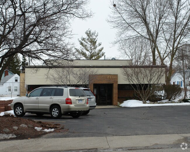
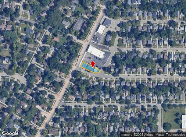
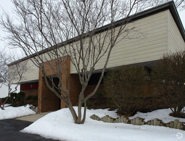
Property Record
2436 Plainfield Ave Ne, Grand Rapids, MI 49505
NEARBY LISTINGS FOR SALE OR LEASE
Property Detail
2436 Plainfield Ave Ne
Grand Rapids-Wyoming, MI
Pasadena Park Plat
41-14-07-281-003
LOT 284 ALSO THAT PART OF VAC PORTION OF ARLINGTON ST ADJ TO LOT 284 ON THE S ALSO THAT PART OF VAC PORTION OF PASADENA DR
Officebuilding
Kent
X
Michigan
26081C0294D
284
2024
0.18 AC
2025
Central Grand Rapids
001000
West Michigan
4,560 SF
DEMOGRAPHICS near 2436 Plainfield Ave Ne
1 Mile
3 Mile
5 Mile
2024 Total Population
11,975
87,229
192,434
2029 Population
12,043
87,437
193,390
Pop Growth 2024-2029
+ 0.57%
+ 0.24%
+ 0.50%
Average Age
40
37
37
2024 Total Households
5,091
37,501
79,356
HH Growth 2024-2029
+ 0.57%
+ 0.28%
+ 0.56%
Median Household Inc
$70,759
$61,318
$66,114
Avg Household Size
2.30
2.20
2.30
2024 Avg HH Vehicles
2.00
2.00
2.00
Median Home Value
$200,376
$209,609
$234,438
Median Year Built
1952
1959
1959
Nearby Places
Map Layers
Map Styles
 Street
 Aerial
- Restaurants
- Banks
- Shops
- Fitness
- Groceries
PUBLIC TRANSPORTATION
COMMUTER RAIL
DRIVE
WALK
Distance
10 min
4.5 mi
AIRPORT
Gerald R Ford International
DRIVE
WALK
Distance
Gerald R Ford International
25 min
16.2 mi
Nearby Properties
Address
Land Use
TOTAL SIZE
Lot Size
Zoning
Address
Land Use
TOTAL SIZE
Lot Size
Zoning
226,925 SF
1.32 AC
TN-CC
Address
Land Use
TOTAL SIZE
Lot Size
Zoning
537,080 SF
46.61 AC
RPUD - 2
Address
Land Use
TOTAL SIZE
Lot Size
Zoning
211,760 SF
TN-CC
Address
Land Use
TOTAL SIZE
Lot Size
Zoning
768,153 SF
3.20 AC
TN-CC
Address
Land Use
TOTAL SIZE
Lot Size
Zoning
491,288 SF
2.79 AC
SD-PRD
Address
Land Use
TOTAL SIZE
Lot Size
Zoning
451,792 SF
32.60 AC
ARM - MULT
Address
Land Use
TOTAL SIZE
Lot Size
Zoning
Address
Land Use
TOTAL SIZE
Lot Size
Zoning
281,488 SF
1.20 AC
TN-CC
Address
Land Use
TOTAL SIZE
Lot Size
Zoning
257,381 SF
7.08 AC
SD-PRD
Address
Land Use
TOTAL SIZE
Lot Size
Zoning
145,306 SF
0.75 AC
TN-CC
Address
Land Use
TOTAL SIZE
Lot Size
Zoning
18.07 AC
MON-LDR
Address
Land Use
TOTAL SIZE
Lot Size
Zoning
94,556 SF
1.03 AC
TN-TCC
Address
Land Use
TOTAL SIZE
Lot Size
Zoning
21.77 AC
MCN-MDR
Address
Land Use
TOTAL SIZE
Lot Size
Zoning
47,370 SF
8.18 AC
MON-LDR
Address
Land Use
TOTAL SIZE
Lot Size
Zoning
366,447 SF
2.71 AC
TN-CC
Address
Land Use
TOTAL SIZE
Lot Size
Zoning
18.65 AC
MCN-MDR
Address
Land Use
TOTAL SIZE
Lot Size
Zoning
363,503 SF
2.20 AC
TN-CC
Address
Land Use
TOTAL SIZE
Lot Size
Zoning
68,560 SF
2.76 AC
TN-TCC
Address
Land Use
TOTAL SIZE
Lot Size
Zoning
Address
Land Use
TOTAL SIZE
Lot Size
Zoning
109,482 SF
1.35 AC
SD-PRD
Address
Land Use
TOTAL SIZE
Lot Size
Zoning
310,790 SF
0.66 AC
TN-CC
Address
Land Use
TOTAL SIZE
Lot Size
Zoning
33.06 AC
R-3
Address
Land Use
TOTAL SIZE
Lot Size
Zoning
0.92 AC
TN-CC
Address
Land Use
TOTAL SIZE
Lot Size
Zoning
137,560 SF
TN-CC
Address
Land Use
TOTAL SIZE
Lot Size
Zoning
24.96 AC
MCN-MDR
Address
Land Use
TOTAL SIZE
Lot Size
Zoning
247,954 SF
40.84 AC
SD-PRD
Address
Land Use
TOTAL SIZE
Lot Size
Zoning
Address
Land Use
TOTAL SIZE
Lot Size
Zoning
158,449 SF
14.33 AC
MCN-MDR
Address
Land Use
TOTAL SIZE
Lot Size
Zoning
104,743 SF
0.34 AC
TN-CC
Address
Land Use
TOTAL SIZE
Lot Size
Zoning
21.10 AC
MON-MDR
The World's #1 Commercial Real Estate Marketplace
Connect with us
© 2025 CoStar Group
The information above has been obtained from sources believed reliable. While we do not doubt its accuracy we have not verified it and make no guarantee, warranty or representation about it. It is your responsibility to independently confirm its accuracy and completeness. Any projections, opinions, assumptions, or estimates used are for example only and do not represent the current or future performance of the property. The value of this transaction to you depends on tax and other factors which should be evaluated by your tax, financial, and legal advisors. You and your advisors should conduct a careful, independent investigation of the property to determine to your satisfaction the suitability of the property for your needs.