Property Record
24385 Main Rd, Cutchogue, NY 11935
NEARBY LISTINGS FOR SALE OR LEASE
Property Detail
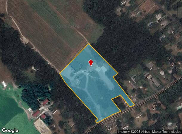
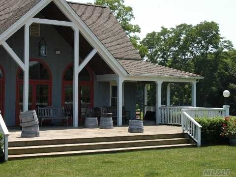
24385 Main Rd
Nassau County-Suffolk County, NY
BOOK 12065 PAGE 350 BILL 013348
1000-109-00-01-00-013-001
Suffolk
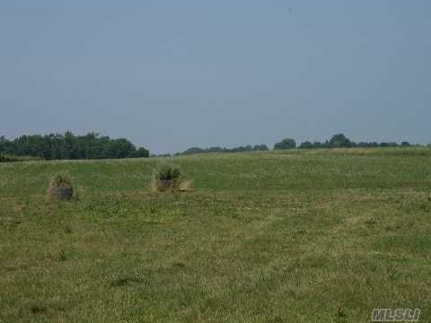
Vineyard
New York
X
13
36103C0163H
6.22 AC
2024
Eastern Suffolk
2024
Long Island (New York)
170006
DEMOGRAPHICS near 24385 Main Rd
1 Mile
3 Mile
5 Mile
2024 Total Population
1,420
9,226
15,288
2029 Population
1,435
9,434
15,688
Pop Growth 2024-2029
+ 1.06%
+ 2.25%
+ 2.62%
Average Age
44
47
47
2024 Total Households
521
3,755
6,249
HH Growth 2024-2029
+ 0.38%
+ 2.18%
+ 2.50%
Median Household Inc
$98,437
$101,441
$101,337
Avg Household Size
2.60
2.40
2.40
2024 Avg HH Vehicles
3.00
2.00
2.00
Median Home Value
$737,198
$728,969
$743,010
Median Year Built
1973
1974
1974
Nearby Places
- Restaurants
- Banks
- Shops
- Fitness
- Groceries
PUBLIC TRANSPORTATION
COMMUTER RAIL
Mattituck Station (Greenport Branch - Long Island Rail Road)
DRIVE
WALK
Distance
Mattituck Station (Greenport Branch - Long Island Rail Road)
4 min
2.4 mi
Southold Station (Greenport Branch - Long Island Rail Road)
DRIVE
WALK
Distance
Southold Station (Greenport Branch - Long Island Rail Road)
11 min
5.9 mi
Freight Ports
Port of New Haven
DRIVE
WALK
Distance
Port of New Haven
163 min
69.4 mi
Nearby Properties
Address
Land Use
TOTAL SIZE
Lot Size
Zoning
Address
Land Use
TOTAL SIZE
Lot Size
Zoning
30.40 AC
R-80
Address
Land Use
TOTAL SIZE
Lot Size
Zoning
26.14 AC
R-80
Address
Land Use
TOTAL SIZE
Lot Size
Zoning
0.79 AC
VILLA
Address
Land Use
TOTAL SIZE
Lot Size
Zoning
8.75 AC
B
Address
Land Use
TOTAL SIZE
Lot Size
Zoning
Address
Land Use
TOTAL SIZE
Lot Size
Zoning
17.40 AC
RR
Address
Land Use
TOTAL SIZE
Lot Size
Zoning
5.60 AC
RO R-40
Address
Land Use
TOTAL SIZE
Lot Size
Zoning
4.91 AC
B
Address
Land Use
TOTAL SIZE
Lot Size
Zoning
1.34 AC
HB
Address
Land Use
TOTAL SIZE
Lot Size
Zoning
0.47 AC
BUS1
Address
Land Use
TOTAL SIZE
Lot Size
Zoning
78.34 AC
AC
Address
Land Use
TOTAL SIZE
Lot Size
Zoning
Address
Land Use
TOTAL SIZE
Lot Size
Zoning
32.26 AC
R-80 R-40
Address
Land Use
TOTAL SIZE
Lot Size
Zoning
7.20 AC
AC
Address
Land Use
TOTAL SIZE
Lot Size
Zoning
72.30 AC
AC R-80
Address
Land Use
TOTAL SIZE
Lot Size
Zoning
59.94 AC
LI
Address
Land Use
TOTAL SIZE
Lot Size
Zoning
6 AC
R-40
Address
Land Use
TOTAL SIZE
Lot Size
Zoning
8.50 AC
MII
Address
Land Use
TOTAL SIZE
Lot Size
Zoning
10.70 AC
R-40
Address
Land Use
TOTAL SIZE
Lot Size
Zoning
6.84 AC
AC
Address
Land Use
TOTAL SIZE
Lot Size
Zoning
32.60 AC
MII R-80
Address
Land Use
TOTAL SIZE
Lot Size
Zoning
Address
Land Use
TOTAL SIZE
Lot Size
Zoning
5.65 AC
LI
Address
Land Use
TOTAL SIZE
Lot Size
Zoning
99.76 AC
AC R-40
Address
Land Use
TOTAL SIZE
Lot Size
Zoning
1.50 AC
RO R-40
Address
Land Use
TOTAL SIZE
Lot Size
Zoning
6.52 AC
LI
Address
Land Use
TOTAL SIZE
Lot Size
Zoning
3.07 AC
LI
Address
Land Use
TOTAL SIZE
Lot Size
Zoning
21.24 AC
HD
Address
Land Use
TOTAL SIZE
Lot Size
Zoning
33.68 AC
AC
Address
Land Use
TOTAL SIZE
Lot Size
Zoning
2.61 AC
AC
The World's #1 Commercial Real Estate Marketplace
Connect with us
© 2025 CoStar Group
The information above has been obtained from sources believed reliable. While we do not doubt its accuracy we have not verified it and make no guarantee, warranty or representation about it. It is your responsibility to independently confirm its accuracy and completeness. Any projections, opinions, assumptions, or estimates used are for example only and do not represent the current or future performance of the property. The value of this transaction to you depends on tax and other factors which should be evaluated by your tax, financial, and legal advisors. You and your advisors should conduct a careful, independent investigation of the property to determine to your satisfaction the suitability of the property for your needs.