Property Record
244 Amesbury Rd, Kensington, NH 03833
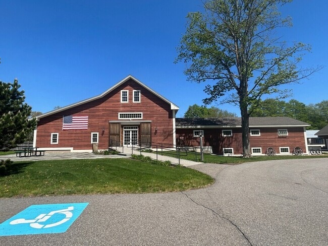

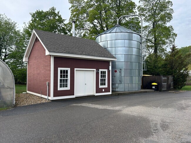
This Property Is For Sale
NEARBY LISTINGS FOR SALE OR LEASE
Property Detail
244 Amesbury Rd
KENS-000003-000000-000026
Rockingham
Commercialbuilding
New Hampshire
X
26
33015C0420F
2.24 AC
2024
Rockingham
2024
Boston
062500
Boston-Cambridge-Newton, MA-NH
4,101 SF
DEMOGRAPHICS near 244 Amesbury Rd
1 Mile
3 Mile
5 Mile
2024 Total Population
514
9,943
44,262
2029 Population
505
10,179
45,134
Pop Growth 2024-2029
(1.75%)
+ 2.37%
+ 1.97%
Average Age
45
45
45
2024 Total Households
190
3,996
18,501
HH Growth 2024-2029
(2.11%)
+ 2.50%
+ 1.94%
Median Household Inc
$147,726
$108,753
$98,325
Avg Household Size
2.70
2.50
2.30
2024 Avg HH Vehicles
2.00
2.00
2.00
Median Home Value
$698,113
$600,324
$536,449
Median Year Built
1982
1983
1978
Nearby Places
Map Layers
Map Styles
 Street
 Aerial
- Restaurants
- Banks
- Shops
- Fitness
- Groceries
PUBLIC TRANSPORTATION
COMMUTER RAIL
Exeter (Downeaster - Amtrak)
DRIVE
WALK
Distance
Exeter (Downeaster - Amtrak)
13 min
6.1 mi
AIRPORT
Portsmouth International at Pease
DRIVE
WALK
Distance
Portsmouth International at Pease
27 min
17.9 mi
Manchester Boston Regional
DRIVE
WALK
Distance
Manchester Boston Regional
62 min
39.6 mi
Freight Ports
Port of Boston
DRIVE
WALK
Distance
Port of Boston
64 min
46.5 mi
Nearby Properties
Address
Land Use
TOTAL SIZE
Lot Size
Zoning
Address
Land Use
TOTAL SIZE
Lot Size
Zoning
55,934 SF
35.25 AC
A
Address
Land Use
TOTAL SIZE
Lot Size
Zoning
504,280 SF
80.02 AC
I3
Address
Land Use
TOTAL SIZE
Lot Size
Zoning
Address
Land Use
TOTAL SIZE
Lot Size
Zoning
87,374 SF
21.66 AC
LA3
Address
Land Use
TOTAL SIZE
Lot Size
Zoning
7,936 SF
12.80 AC
A
Address
Land Use
TOTAL SIZE
Lot Size
Zoning
20,160 SF
4.81 AC
A
Address
Land Use
TOTAL SIZE
Lot Size
Zoning
78,886 SF
75.81 AC
C2
Address
Land Use
TOTAL SIZE
Lot Size
Zoning
11,904 SF
7.83 AC
A
Address
Land Use
TOTAL SIZE
Lot Size
Zoning
1,056 SF
63.40 AC
40
Address
Land Use
TOTAL SIZE
Lot Size
Zoning
136,020 SF
8.03 AC
I5
Address
Land Use
TOTAL SIZE
Lot Size
Zoning
57,215 SF
4.40 AC
TOWN C
Address
Land Use
TOTAL SIZE
Lot Size
Zoning
11,907 SF
4.03 AC
A
Address
Land Use
TOTAL SIZE
Lot Size
Zoning
58,391 SF
14.11 AC
OSC
Address
Land Use
TOTAL SIZE
Lot Size
Zoning
42,828 SF
4.69 AC
LA2
Address
Land Use
TOTAL SIZE
Lot Size
Zoning
10,944 SF
2.47 AC
LA4
Address
Land Use
TOTAL SIZE
Lot Size
Zoning
48,120 SF
7.15 AC
C2
Address
Land Use
TOTAL SIZE
Lot Size
Zoning
109,528 SF
11 AC
LA3
Address
Land Use
TOTAL SIZE
Lot Size
Zoning
110,350 SF
15.86 AC
I3
Address
Land Use
TOTAL SIZE
Lot Size
Zoning
19.89 AC
IL
Address
Land Use
TOTAL SIZE
Lot Size
Zoning
7 AC
RES
Address
Land Use
TOTAL SIZE
Lot Size
Zoning
4,000 SF
31.48 AC
C2
Address
Land Use
TOTAL SIZE
Lot Size
Zoning
14,488 SF
6.16 AC
C2
Address
Land Use
TOTAL SIZE
Lot Size
Zoning
5,249 SF
10 AC
C3
Address
Land Use
TOTAL SIZE
Lot Size
Zoning
31,974 SF
6.01 AC
C2
Address
Land Use
TOTAL SIZE
Lot Size
Zoning
29,539 SF
6.13 AC
RES
Address
Land Use
TOTAL SIZE
Lot Size
Zoning
26,470 SF
4.70 AC
I3
Address
Land Use
TOTAL SIZE
Lot Size
Zoning
29,330 SF
1.75 AC
C2
Address
Land Use
TOTAL SIZE
Lot Size
Zoning
42,556 SF
5.62 AC
I4
Address
Land Use
TOTAL SIZE
Lot Size
Zoning
1,354 SF
14.92 AC
RES
Address
Land Use
TOTAL SIZE
Lot Size
Zoning
57,168 SF
4.91 AC
I4
The World's #1 Commercial Real Estate Marketplace
Connect with us
© 2025 CoStar Group
The information above has been obtained from sources believed reliable. While we do not doubt its accuracy we have not verified it and make no guarantee, warranty or representation about it. It is your responsibility to independently confirm its accuracy and completeness. Any projections, opinions, assumptions, or estimates used are for example only and do not represent the current or future performance of the property. The value of this transaction to you depends on tax and other factors which should be evaluated by your tax, financial, and legal advisors. You and your advisors should conduct a careful, independent investigation of the property to determine to your satisfaction the suitability of the property for your needs.