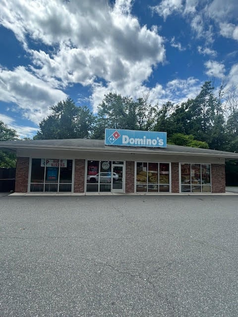
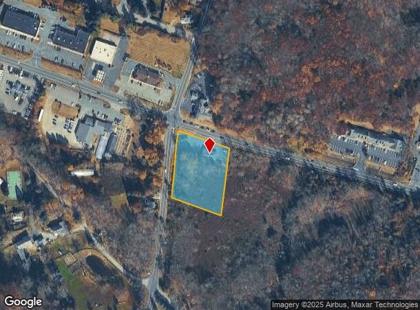
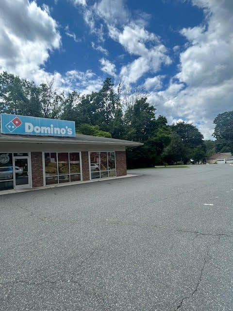
Property Record
244 Newton Sparta Rd, Newton, NJ 07860

NEARBY LISTINGS FOR SALE OR LEASE
Property Detail
244 Newton Sparta Rd
02-00103-0000-00004-01
Sussex
Commercialnec
New Jersey
X
4.1
34037C0315E
1.73 AC
2024
Sussex County
2025
Northern New Jersey
374200
Newark, NJ-PA
DEMOGRAPHICS near 244 Newton Sparta Rd
1 Mile
3 Mile
5 Mile
2024 Total Population
2,249
16,893
37,880
2029 Population
2,251
17,081
38,279
Pop Growth 2024-2029
+ 0.09%
+ 1.11%
+ 1.05%
Average Age
47
43
43
2024 Total Households
690
6,257
14,225
HH Growth 2024-2029
0.00%
+ 1.15%
+ 1.09%
Median Household Inc
$145,955
$122,238
$115,390
Avg Household Size
2.60
2.60
2.60
2024 Avg HH Vehicles
2.00
2.00
2.00
Median Home Value
$415,873
$377,179
$369,517
Median Year Built
1978
1968
1972
Nearby Places
Map Layers
Map Styles
 Street
 Aerial
- Restaurants
- Banks
- Shops
- Fitness
- Groceries
PUBLIC TRANSPORTATION
AIRPORT
Newark Liberty International
DRIVE
WALK
Distance
Newark Liberty International
63 min
46.2 mi
Freight Ports
Maher Terminal
DRIVE
WALK
Distance
Maher Terminal
68 min
46.8 mi
SALE & LEASE HISTORY
LISTING DATE
SALE/LEASE

Aug 15, 2024
For Sale
Nearby Properties
Address
Land Use
TOTAL SIZE
Lot Size
Zoning
Address
Land Use
TOTAL SIZE
Lot Size
Zoning
4.56 AC
T-4
Address
Land Use
TOTAL SIZE
Lot Size
Zoning
47,400 SF
71 AC
SD-4
Address
Land Use
TOTAL SIZE
Lot Size
Zoning
Address
Land Use
TOTAL SIZE
Lot Size
Zoning
2.09 AC
T-5
Address
Land Use
TOTAL SIZE
Lot Size
Zoning
50,814 SF
8.62 AC
SD-3
Address
Land Use
TOTAL SIZE
Lot Size
Zoning
26,185 SF
552.92 AC
I/A
Address
Land Use
TOTAL SIZE
Lot Size
Zoning
10 AC
RR
Address
Land Use
TOTAL SIZE
Lot Size
Zoning
50,659 SF
9.90 AC
C-2
Address
Land Use
TOTAL SIZE
Lot Size
Zoning
45,532 SF
10.31 AC
R1
Address
Land Use
TOTAL SIZE
Lot Size
Zoning
1,140 SF
1.45 AC
SD-6
Address
Land Use
TOTAL SIZE
Lot Size
Zoning
11 AC
SD-6
Address
Land Use
TOTAL SIZE
Lot Size
Zoning
58,607 SF
26.13 AC
RR
Address
Land Use
TOTAL SIZE
Lot Size
Zoning
14,866 SF
2.09 AC
T-5
Address
Land Use
TOTAL SIZE
Lot Size
Zoning
76,409 SF
29.80 AC
R2
Address
Land Use
TOTAL SIZE
Lot Size
Zoning
Address
Land Use
TOTAL SIZE
Lot Size
Zoning
3,280 SF
17.30 AC
MF
Address
Land Use
TOTAL SIZE
Lot Size
Zoning
11,843 SF
9.68 AC
RR
Address
Land Use
TOTAL SIZE
Lot Size
Zoning
35,884 SF
4.73 AC
C-2
Address
Land Use
TOTAL SIZE
Lot Size
Zoning
83,930 SF
7.43 AC
T-3
Address
Land Use
TOTAL SIZE
Lot Size
Zoning
38,004 SF
3.08 AC
R2
Address
Land Use
TOTAL SIZE
Lot Size
Zoning
528 SF
10.85 AC
RR
Address
Land Use
TOTAL SIZE
Lot Size
Zoning
5 AC
R1
Address
Land Use
TOTAL SIZE
Lot Size
Zoning
14,967 SF
82.85 AC
RR
Address
Land Use
TOTAL SIZE
Lot Size
Zoning
3.51 AC
T-3
Address
Land Use
TOTAL SIZE
Lot Size
Zoning
23,184 SF
82.13 AC
OSGU
Address
Land Use
TOTAL SIZE
Lot Size
Zoning
42,036 SF
2.94 AC
C-1
Address
Land Use
TOTAL SIZE
Lot Size
Zoning
11,880 SF
1.61 AC
T-4
Address
Land Use
TOTAL SIZE
Lot Size
Zoning
45,445 SF
8.65 AC
ED
Address
Land Use
TOTAL SIZE
Lot Size
Zoning
28,317 SF
1.36 AC
C-2
Address
Land Use
TOTAL SIZE
Lot Size
Zoning
23,812 SF
2.29 AC
C-1
The World's #1 Commercial Real Estate Marketplace
Connect with us
© 2025 CoStar Group
The information above has been obtained from sources believed reliable. While we do not doubt its accuracy we have not verified it and make no guarantee, warranty or representation about it. It is your responsibility to independently confirm its accuracy and completeness. Any projections, opinions, assumptions, or estimates used are for example only and do not represent the current or future performance of the property. The value of this transaction to you depends on tax and other factors which should be evaluated by your tax, financial, and legal advisors. You and your advisors should conduct a careful, independent investigation of the property to determine to your satisfaction the suitability of the property for your needs.