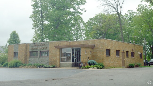
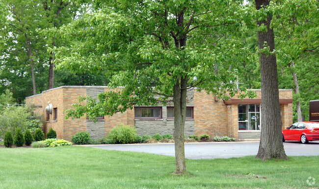
Property Record
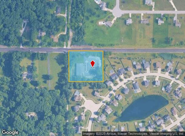
244 W Us Highway 6, Valparaiso, IN 46385
NEARBY LISTINGS FOR SALE OR LEASE
Property Detail
244 W Us Highway 6
64-06-28-201-023.000-006
N297 W330 N65A NE 28-36-6 2.25A
Officebuilding
Porter
X
Indiana
18127C0136D
2.25 AC
2023
Porter County
2024
Chicago
050105
Chicago-Naperville-Elgin, IL-IN-WI
8,396 SF
DEMOGRAPHICS near 244 W Us Highway 6
1 Mile
3 Mile
5 Mile
2024 Total Population
2,443
23,157
79,835
2029 Population
2,438
23,500
81,662
Pop Growth 2024-2029
(0.20%)
+ 1.48%
+ 2.29%
Average Age
41
40
40
2024 Total Households
923
8,528
30,573
HH Growth 2024-2029
(0.43%)
+ 1.44%
+ 2.31%
Median Household Inc
$78,710
$76,864
$77,225
Avg Household Size
2.60
2.70
2.50
2024 Avg HH Vehicles
2.00
2.00
2.00
Median Home Value
$200,254
$217,984
$232,292
Median Year Built
1973
1986
1984
Nearby Places
- Restaurants
- Banks
- Shops
- Fitness
- Groceries
PUBLIC TRANSPORTATION
COMMUTER RAIL
Ogden Dunes (Portage) Station (South Shore Line - Northern Indiana Commuter Transportation District (South Shore Line))
DRIVE
WALK
Distance
Ogden Dunes (Portage) Station (South Shore Line - Northern Indiana Commuter Transportation District (South Shore Line))
12 min
8.4 mi
Dune Park (Chesterton) Station (South Shore Line - Northern Indiana Commuter Transportation District (South Shore Line))
DRIVE
WALK
Distance
Dune Park (Chesterton) Station (South Shore Line - Northern Indiana Commuter Transportation District (South Shore Line))
14 min
9.2 mi
Freight Ports
Port Milwaukee
DRIVE
WALK
Distance
Port Milwaukee
166 min
130.5 mi
Nearby Properties
Address
Land Use
TOTAL SIZE
Lot Size
Zoning
Address
Land Use
TOTAL SIZE
Lot Size
Zoning
218,452 SF
87 SF
Address
Land Use
TOTAL SIZE
Lot Size
Zoning
168,126 SF
44 SF
Address
Land Use
TOTAL SIZE
Lot Size
Zoning
133,249 SF
44 SF
Address
Land Use
TOTAL SIZE
Lot Size
Zoning
69,459 SF
13.97 AC
Address
Land Use
TOTAL SIZE
Lot Size
Zoning
118,798 SF
44 SF
Address
Land Use
TOTAL SIZE
Lot Size
Zoning
95,281 SF
44 SF
Address
Land Use
TOTAL SIZE
Lot Size
Zoning
56,308 SF
44 SF
Address
Land Use
TOTAL SIZE
Lot Size
Zoning
89,232 SF
44 SF
Address
Land Use
TOTAL SIZE
Lot Size
Zoning
15,644 SF
0.03 AC
Address
Land Use
TOTAL SIZE
Lot Size
Zoning
72,400 SF
2.82 AC
Address
Land Use
TOTAL SIZE
Lot Size
Zoning
26,580 SF
2.57 AC
Address
Land Use
TOTAL SIZE
Lot Size
Zoning
20,831 SF
2.49 AC
Address
Land Use
TOTAL SIZE
Lot Size
Zoning
8,820 SF
0.02 AC
Address
Land Use
TOTAL SIZE
Lot Size
Zoning
49,947 SF
44 SF
Address
Land Use
TOTAL SIZE
Lot Size
Zoning
51,466 SF
4.40 AC
Address
Land Use
TOTAL SIZE
Lot Size
Zoning
17,500 SF
2.08 AC
Address
Land Use
TOTAL SIZE
Lot Size
Zoning
16,000 SF
1.67 AC
Address
Land Use
TOTAL SIZE
Lot Size
Zoning
12,160 SF
1.78 AC
Address
Land Use
TOTAL SIZE
Lot Size
Zoning
66,766 SF
44 SF
Address
Land Use
TOTAL SIZE
Lot Size
Zoning
52,800 SF
4 AC
Address
Land Use
TOTAL SIZE
Lot Size
Zoning
4,540 SF
2.98 AC
Address
Land Use
TOTAL SIZE
Lot Size
Zoning
11,105 SF
4.20 AC
Address
Land Use
TOTAL SIZE
Lot Size
Zoning
31.23 AC
Address
Land Use
TOTAL SIZE
Lot Size
Zoning
38,094 SF
1.88 AC
Address
Land Use
TOTAL SIZE
Lot Size
Zoning
9,611 SF
2.64 AC
Address
Land Use
TOTAL SIZE
Lot Size
Zoning
8,800 SF
39.66 AC
Address
Land Use
TOTAL SIZE
Lot Size
Zoning
8,950 SF
0.91 AC
Address
Land Use
TOTAL SIZE
Lot Size
Zoning
19,140 SF
1.24 AC
Address
Land Use
TOTAL SIZE
Lot Size
Zoning
47,972 SF
3.99 AC
Address
Land Use
TOTAL SIZE
Lot Size
Zoning
6,000 SF
1.50 AC
The World's #1 Commercial Real Estate Marketplace
Connect with us
© 2025 CoStar Group
The information above has been obtained from sources believed reliable. While we do not doubt its accuracy we have not verified it and make no guarantee, warranty or representation about it. It is your responsibility to independently confirm its accuracy and completeness. Any projections, opinions, assumptions, or estimates used are for example only and do not represent the current or future performance of the property. The value of this transaction to you depends on tax and other factors which should be evaluated by your tax, financial, and legal advisors. You and your advisors should conduct a careful, independent investigation of the property to determine to your satisfaction the suitability of the property for your needs.