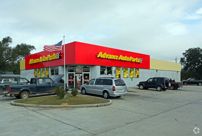
Property Record
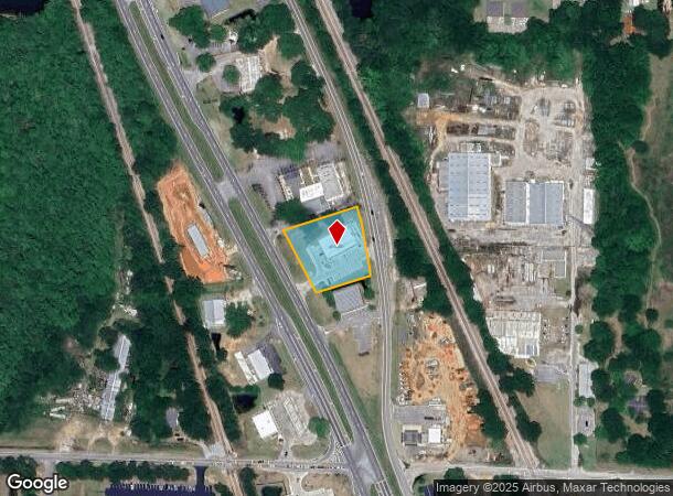
2440 S Highway 29 St, Cantonment, FL 32533

NEARBY LISTINGS FOR SALE OR LEASE
Property Detail
2440 S Highway 29 St
Pensacola-Ferry Pass-Brent, FL
Subdivision Number: 3401
20-1N-30-3401-006-001
BEG AT SW COR OF SE1/4 E 112 FT TO E LI OF H/W NLY ALG R/W 581 96/100 FT FOR POB CONTINUE NLY 200 FT DEFLECTING ANG 100 DEG TO RT 215 2/10 FT TO W LI OF H/W SLY ALG R/W 199 3/10 FT WLY 154 FT TO POB OR 4008 P 82
Storemultistory
Escambia
X
Florida
12113C0385H
6
2023
0.85 AC
2024
Gonzalez/SW Santa Rosa
003610
Pensacola
6,725 SF
DEMOGRAPHICS near 2440 S Highway 29 St
1 Mile
3 Mile
5 Mile
2024 Total Population
4,030
30,909
69,717
2029 Population
4,016
31,117
71,100
Pop Growth 2024-2029
(0.35%)
+ 0.67%
+ 1.98%
Average Age
41
40
41
2024 Total Households
1,550
12,385
27,933
HH Growth 2024-2029
(0.32%)
+ 0.75%
+ 1.96%
Median Household Inc
$80,589
$66,851
$61,236
Avg Household Size
2.50
2.40
2.40
2024 Avg HH Vehicles
2.00
2.00
2.00
Median Home Value
$224,421
$223,612
$217,504
Median Year Built
1989
1991
1990
Nearby Places
Map Layers
Map Styles
 Street
 Aerial
- Restaurants
- Banks
- Shops
- Fitness
- Groceries
PUBLIC TRANSPORTATION
AIRPORT
Pensacola International
DRIVE
WALK
Distance
Pensacola International
22 min
12.1 mi
Nearby Properties
Address
Land Use
TOTAL SIZE
Lot Size
Zoning
Address
Land Use
TOTAL SIZE
Lot Size
Zoning
295,911 SF
15.53 AC
HC/LI,HDR
Address
Land Use
TOTAL SIZE
Lot Size
Zoning
303,273 SF
9.95 AC
HC/LI
Address
Land Use
TOTAL SIZE
Lot Size
Zoning
264,273 SF
15.97 AC
HC/LI
Address
Land Use
TOTAL SIZE
Lot Size
Zoning
263,838 SF
9.03 AC
HC/LI
Address
Land Use
TOTAL SIZE
Lot Size
Zoning
274,822 SF
12.67 AC
HC/LI
Address
Land Use
TOTAL SIZE
Lot Size
Zoning
1,736,528 SF
1,780.92 AC
IND
Address
Land Use
TOTAL SIZE
Lot Size
Zoning
317,266 SF
58.88 AC
LDMU,PUB
Address
Land Use
TOTAL SIZE
Lot Size
Zoning
219,541 SF
18.71 AC
HC/LI
Address
Land Use
TOTAL SIZE
Lot Size
Zoning
159,935 SF
1 AC
IND
Address
Land Use
TOTAL SIZE
Lot Size
Zoning
72,248 SF
6.07 AC
COM,HC/LI
Address
Land Use
TOTAL SIZE
Lot Size
Zoning
258,979 SF
100 AC
PUB
Address
Land Use
TOTAL SIZE
Lot Size
Zoning
151,363 SF
12.17 AC
HC/LI
Address
Land Use
TOTAL SIZE
Lot Size
Zoning
102,087 SF
301.41 AC
IND
Address
Land Use
TOTAL SIZE
Lot Size
Zoning
140,190 SF
13.05 AC
HC/LI
Address
Land Use
TOTAL SIZE
Lot Size
Zoning
129,314 SF
4.48 AC
COM
Address
Land Use
TOTAL SIZE
Lot Size
Zoning
103,670 SF
10.10 AC
HC/LI
Address
Land Use
TOTAL SIZE
Lot Size
Zoning
27,752 SF
5.03 AC
COM
Address
Land Use
TOTAL SIZE
Lot Size
Zoning
77,537 SF
6.57 AC
HC/LI
Address
Land Use
TOTAL SIZE
Lot Size
Zoning
83,586 SF
7.77 AC
HC/LI
Address
Land Use
TOTAL SIZE
Lot Size
Zoning
55,506 SF
5.03 AC
HDMU
Address
Land Use
TOTAL SIZE
Lot Size
Zoning
55,683 SF
8.92 AC
HC/LI
Address
Land Use
TOTAL SIZE
Lot Size
Zoning
44,395 SF
6.97 AC
HC/LI
Address
Land Use
TOTAL SIZE
Lot Size
Zoning
43,628 SF
6.26 AC
HC/LI
Address
Land Use
TOTAL SIZE
Lot Size
Zoning
53,977 SF
5.25 AC
COM
Address
Land Use
TOTAL SIZE
Lot Size
Zoning
64,752 SF
3.01 AC
HC/LI
Address
Land Use
TOTAL SIZE
Lot Size
Zoning
30,544 SF
10 AC
HC/LI
Address
Land Use
TOTAL SIZE
Lot Size
Zoning
62,505 SF
5.88 AC
HC/LI
Address
Land Use
TOTAL SIZE
Lot Size
Zoning
77,192 SF
5.52 AC
HC/LI,HDMU
Address
Land Use
TOTAL SIZE
Lot Size
Zoning
62,394 SF
7.86 AC
HC/LI
Address
Land Use
TOTAL SIZE
Lot Size
Zoning
69,300 SF
3.19 AC
COM
The World's #1 Commercial Real Estate Marketplace
Connect with us
© 2025 CoStar Group
The information above has been obtained from sources believed reliable. While we do not doubt its accuracy we have not verified it and make no guarantee, warranty or representation about it. It is your responsibility to independently confirm its accuracy and completeness. Any projections, opinions, assumptions, or estimates used are for example only and do not represent the current or future performance of the property. The value of this transaction to you depends on tax and other factors which should be evaluated by your tax, financial, and legal advisors. You and your advisors should conduct a careful, independent investigation of the property to determine to your satisfaction the suitability of the property for your needs.