Property Record
2440 State Highway 32, Cornwall, NY 12518
NEARBY LISTINGS FOR SALE OR LEASE
Property Detail
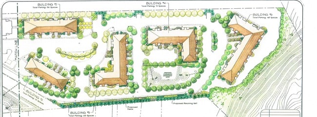
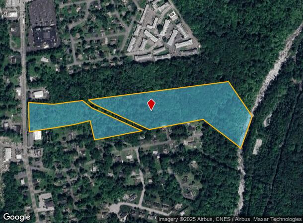
2440 State Highway 32
Kiryas Joel-Poughkeepsie-Newburgh, NY
Haber
332489-009-000-0001-054.000-0000
LT 2 HABER SUB MAP 284-92LT 2 HABER SUB MAP 151-98
Recreationalacreage
Orange
AE
New York
36071C0333E
54.00
2024
24 AC
2024
Newburgh
013100
Northern New Jersey
DEMOGRAPHICS near 2440 State Highway 32
1 Mile
3 Mile
5 Mile
2024 Total Population
7,242
32,601
76,561
2029 Population
7,520
33,354
78,005
Pop Growth 2024-2029
+ 3.84%
+ 2.31%
+ 1.89%
Average Age
40
41
39
2024 Total Households
2,891
12,659
27,964
HH Growth 2024-2029
+ 4.19%
+ 2.46%
+ 2.06%
Median Household Inc
$91,480
$98,677
$82,523
Avg Household Size
2.50
2.50
2.60
2024 Avg HH Vehicles
2.00
2.00
2.00
Median Home Value
$316,540
$322,502
$300,625
Median Year Built
1973
1972
1963
Nearby Places
Map Layers
Map Styles
 Street
 Aerial
- Restaurants
- Banks
- Shops
- Fitness
- Groceries
PUBLIC TRANSPORTATION
COMMUTER RAIL
Salisbury Mills Cornwall (Bergen County/Port Jervis Line - NJ Transit Commuter Rail (NJ Transit), Main/Port Jervis Line - NJ Transit Commuter Rail (NJ Transit))
DRIVE
WALK
Distance
Salisbury Mills Cornwall (Bergen County/Port Jervis Line - NJ Transit Commuter Rail (NJ Transit), Main/Port Jervis Line - NJ Transit Commuter Rail (NJ Transit))
8 min
3.7 mi
AIRPORT
New York Stewart International
DRIVE
WALK
Distance
New York Stewart International
12 min
5.9 mi
Freight Ports
Port Newark Container Terminal
DRIVE
WALK
Distance
Port Newark Container Terminal
90 min
63.1 mi
SALE & LEASE HISTORY
LISTING DATE
SALE/LEASE

Sep 24, 2016
For Sale
Nearby Properties
Address
Land Use
TOTAL SIZE
Lot Size
Zoning
Address
Land Use
TOTAL SIZE
Lot Size
Zoning
183,335 SF
12.40 AC
Address
Land Use
TOTAL SIZE
Lot Size
Zoning
115,270 SF
49.30 AC
Address
Land Use
TOTAL SIZE
Lot Size
Zoning
364,010 SF
83 AC
R2
Address
Land Use
TOTAL SIZE
Lot Size
Zoning
50 AC
Address
Land Use
TOTAL SIZE
Lot Size
Zoning
Address
Land Use
TOTAL SIZE
Lot Size
Zoning
249,379 SF
29.34 AC
Address
Land Use
TOTAL SIZE
Lot Size
Zoning
173,706 SF
11.10 AC
Address
Land Use
TOTAL SIZE
Lot Size
Zoning
101,510 SF
12.80 AC
Address
Land Use
TOTAL SIZE
Lot Size
Zoning
139,016 SF
3 AC
Address
Land Use
TOTAL SIZE
Lot Size
Zoning
35,012 SF
Address
Land Use
TOTAL SIZE
Lot Size
Zoning
Address
Land Use
TOTAL SIZE
Lot Size
Zoning
25,800 SF
7.90 AC
R4
Address
Land Use
TOTAL SIZE
Lot Size
Zoning
50,096 SF
4.80 AC
Address
Land Use
TOTAL SIZE
Lot Size
Zoning
43,604 SF
0.66 AC
Address
Land Use
TOTAL SIZE
Lot Size
Zoning
8,053 SF
8.40 AC
Address
Land Use
TOTAL SIZE
Lot Size
Zoning
66.10 AC
R4
Address
Land Use
TOTAL SIZE
Lot Size
Zoning
37,616 SF
25.10 AC
Address
Land Use
TOTAL SIZE
Lot Size
Zoning
Address
Land Use
TOTAL SIZE
Lot Size
Zoning
29.50 AC
Address
Land Use
TOTAL SIZE
Lot Size
Zoning
39.80 AC
R4
Address
Land Use
TOTAL SIZE
Lot Size
Zoning
18,592 SF
26.50 AC
Address
Land Use
TOTAL SIZE
Lot Size
Zoning
35,018 SF
3.80 AC
Address
Land Use
TOTAL SIZE
Lot Size
Zoning
27,679 SF
26.60 AC
04
Address
Land Use
TOTAL SIZE
Lot Size
Zoning
Address
Land Use
TOTAL SIZE
Lot Size
Zoning
60,076 SF
3.60 AC
02
Address
Land Use
TOTAL SIZE
Lot Size
Zoning
56,004 SF
5.30 AC
R4
Address
Land Use
TOTAL SIZE
Lot Size
Zoning
179.20 AC
Address
Land Use
TOTAL SIZE
Lot Size
Zoning
15.10 AC
R-5
Address
Land Use
TOTAL SIZE
Lot Size
Zoning
12,040 SF
1.22 AC
Address
Land Use
TOTAL SIZE
Lot Size
Zoning
17,420 SF
21 AC
The World's #1 Commercial Real Estate Marketplace
Connect with us
© 2026 CoStar Group
The information above has been obtained from sources believed reliable. While we do not doubt its accuracy we have not verified it and make no guarantee, warranty or representation about it. It is your responsibility to independently confirm its accuracy and completeness. Any projections, opinions, assumptions, or estimates used are for example only and do not represent the current or future performance of the property. The value of this transaction to you depends on tax and other factors which should be evaluated by your tax, financial, and legal advisors. You and your advisors should conduct a careful, independent investigation of the property to determine to your satisfaction the suitability of the property for your needs.