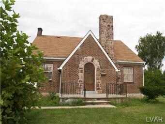
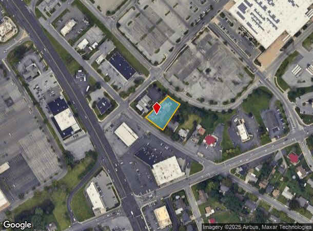
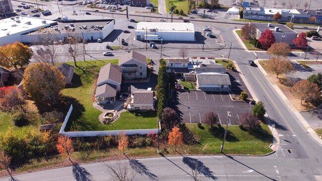
Property Record
2443 Mickley Ave, Whitehall, PA 18052
NEARBY LISTINGS FOR SALE OR LEASE
Property Detail
2443 Mickley Ave
Allentown-Bethlehem-Easton, PA-NJ
Mickley Manor
549855625306-1
Lehigh
Sfr
Pennsylvania
X
0.40 AC
42095C0238E
Lehigh Valley
2,630 SF
Philadelphia
DEMOGRAPHICS near 2443 Mickley Ave
1 Mile
3 Mile
5 Mile
2024 Total Population
9,082
105,581
221,735
2029 Population
9,159
106,216
223,386
Pop Growth 2024-2029
+ 0.85%
+ 0.60%
+ 0.74%
Average Age
42
38
39
2024 Total Households
3,671
39,675
84,801
HH Growth 2024-2029
+ 0.74%
+ 0.64%
+ 0.80%
Median Household Inc
$56,697
$53,010
$58,197
Avg Household Size
2.40
2.60
2.50
2024 Avg HH Vehicles
2.00
2.00
2.00
Median Home Value
$219,393
$187,731
$208,499
Median Year Built
1969
1953
1959
Nearby Places
Map Layers
Map Styles
 Street
 Aerial
- Restaurants
- Banks
- Shops
- Fitness
- Groceries
PUBLIC TRANSPORTATION
AIRPORT
Lehigh Valley International
DRIVE
WALK
Distance
Lehigh Valley International
10 min
3.9 mi
Freight Ports
Port of Philadelphia
DRIVE
WALK
Distance
Port of Philadelphia
87 min
64.6 mi
SALE & LEASE HISTORY
LISTING DATE
SALE/LEASE

Nov 20, 2022
For Sale
Nearby Properties
Address
Land Use
TOTAL SIZE
Lot Size
Zoning
Address
Land Use
TOTAL SIZE
Lot Size
Zoning
93,719 SF
789.61 AC
AI
Address
Land Use
TOTAL SIZE
Lot Size
Zoning
302,304 SF
5.15 AC
B-2
Address
Land Use
TOTAL SIZE
Lot Size
Zoning
187,337 SF
2.11 AC
I-G
Address
Land Use
TOTAL SIZE
Lot Size
Zoning
74,985 SF
112.49 AC
RR-2
Address
Land Use
TOTAL SIZE
Lot Size
Zoning
298,543 SF
55.08 AC
PIO
Address
Land Use
TOTAL SIZE
Lot Size
Zoning
230,853 SF
96.66 AC
R-3
Address
Land Use
TOTAL SIZE
Lot Size
Zoning
505,128 SF
25.92 AC
C-2
Address
Land Use
TOTAL SIZE
Lot Size
Zoning
356,283 SF
2 AC
I-G
Address
Land Use
TOTAL SIZE
Lot Size
Zoning
295,502 SF
0.77 AC
B-2
Address
Land Use
TOTAL SIZE
Lot Size
Zoning
453,600 SF
32.57 AC
PIO
Address
Land Use
TOTAL SIZE
Lot Size
Zoning
229,379 SF
1.16 AC
I-G
Address
Land Use
TOTAL SIZE
Lot Size
Zoning
175,714 SF
46.35 AC
R-3
Address
Land Use
TOTAL SIZE
Lot Size
Zoning
1,046,625 SF
69.55 AC
RS
Address
Land Use
TOTAL SIZE
Lot Size
Zoning
520,201 SF
77.66 AC
PIO
Address
Land Use
TOTAL SIZE
Lot Size
Zoning
314,421 SF
2.22 AC
I-G
Address
Land Use
TOTAL SIZE
Lot Size
Zoning
25.75 AC
B/LI
Address
Land Use
TOTAL SIZE
Lot Size
Zoning
155,344 SF
B-2
Address
Land Use
TOTAL SIZE
Lot Size
Zoning
504,475 SF
39.36 AC
I
Address
Land Use
TOTAL SIZE
Lot Size
Zoning
252,920 SF
12.88 AC
I-G
Address
Land Use
TOTAL SIZE
Lot Size
Zoning
72,678 SF
17.21 AC
PC
Address
Land Use
TOTAL SIZE
Lot Size
Zoning
266,354 SF
2.56 AC
R-H
Address
Land Use
TOTAL SIZE
Lot Size
Zoning
260,803 SF
36.23 AC
C-2
Address
Land Use
TOTAL SIZE
Lot Size
Zoning
1,050,392 SF
218.15 AC
RS
Address
Land Use
TOTAL SIZE
Lot Size
Zoning
165,557 SF
0.48 AC
B-2
Address
Land Use
TOTAL SIZE
Lot Size
Zoning
113,162 SF
3.02 AC
B/LI
Address
Land Use
TOTAL SIZE
Lot Size
Zoning
214,790 SF
12.09 AC
GC-1
Address
Land Use
TOTAL SIZE
Lot Size
Zoning
85,440 SF
2.10 AC
I-G
Address
Land Use
TOTAL SIZE
Lot Size
Zoning
123,432 SF
30.70 AC
C-2
Address
Land Use
TOTAL SIZE
Lot Size
Zoning
208,086 SF
3.13 AC
R-H
Address
Land Use
TOTAL SIZE
Lot Size
Zoning
326,320 SF
11.73 AC
PC
The World's #1 Commercial Real Estate Marketplace
Connect with us
© 2025 CoStar Group
The information above has been obtained from sources believed reliable. While we do not doubt its accuracy we have not verified it and make no guarantee, warranty or representation about it. It is your responsibility to independently confirm its accuracy and completeness. Any projections, opinions, assumptions, or estimates used are for example only and do not represent the current or future performance of the property. The value of this transaction to you depends on tax and other factors which should be evaluated by your tax, financial, and legal advisors. You and your advisors should conduct a careful, independent investigation of the property to determine to your satisfaction the suitability of the property for your needs.