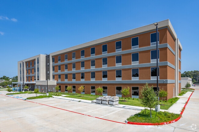
Property Record
24450 Highway 59, Porter, TX 77365

Save to a Folder
{{folder.Name}}
{{folder.ListingIds.length}} Properties
{{folder.ListingIds.length}} Property
Create a New Folder
Property Detail
24450 Highway 59
5554-00-00201
S555400 - GULF COAST NORTHPARK PLACE 01 REPLAT NO 1 AMENDING PLAT NO 2 #2014053834, BLOCK 1, RES B-2, ACRES 2.148
Commercialnec
MONTGOMERY
B and X Area of moderate flood hazard, usually the area between the limits of the 100-year and 500-year floods.
Texas
2024
2.15 AC
2025
Houston North/Woodlands
692304
Houston
66,242 SF
Houston-Pasadena-The Woodlands, TX
NEARBY LISTINGS FOR SALE OR LEASE
-
-
View all Porter listings for sale on LoopNet.com
DEMOGRAPHICS near 24450 Highway 59
1 mile
3 mile
5 mile
2025 Total Population
13,985
58,757
135,338
2030 Population
16,406
66,272
150,510
Pop Growth 2025-2030
+ 17.31%
+ 12.79%
+ 11.21%
Average Age
37
39
38
2025 Total Households
5,985
22,705
48,580
HH Growth 2025-2030
+ 18.13%
+ 13.61%
+ 11.76%
Median Household Inc
$85,597
$87,385
$91,543
Avg Household Size
2.30
2.50
2.70
2025 Avg HH Vehicles
2.00
2.00
2.00
Median Home Value
$338,620
$304,726
$295,913
Median Year Built
2009
2001
1999
Nearby Places
Map Layers
Map Styles
 Street
 Aerial
Layers
 Traffic
 Biking
Places
Listings with unknown addresses are not visible on the map
- Restaurants
- Banks
- Shops
- Fitness
- Groceries
PUBLIC TRANSPORTATION
AIRPORT
George Bush Intcntl/Houston
Drive
Walk
Distance
George Bush Intcntl/Houston
19 min
13.5 mi
William P Hobby
Drive
Walk
Distance
William P Hobby
52 min
35.1 mi
Nearby Properties
Address
Land Use
TOTAL SIZE
Lot Size
Zoning
Address
Land Use
TOTAL SIZE
Lot Size
Zoning
633,347 SF
32.15 AC
5
Address
Land Use
TOTAL SIZE
Lot Size
Zoning
733,100 SF
28.18 AC
Address
Land Use
TOTAL SIZE
Lot Size
Zoning
604,908 SF
58.67 AC
Address
Land Use
TOTAL SIZE
Lot Size
Zoning
363,730 SF
12.59 AC
Address
Land Use
TOTAL SIZE
Lot Size
Zoning
275,500 SF
13.58 AC
Address
Land Use
TOTAL SIZE
Lot Size
Zoning
407,266 SF
25.02 AC
Address
Land Use
TOTAL SIZE
Lot Size
Zoning
288,199 SF
15.50 AC
Address
Land Use
TOTAL SIZE
Lot Size
Zoning
392,395 SF
14.86 AC
5
Address
Land Use
TOTAL SIZE
Lot Size
Zoning
316,815 SF
15.61 AC
Address
Land Use
TOTAL SIZE
Lot Size
Zoning
341,175 SF
65.76 AC
5
Address
Land Use
TOTAL SIZE
Lot Size
Zoning
327,725 SF
22.04 AC
5
Address
Land Use
TOTAL SIZE
Lot Size
Zoning
284,662 SF
14.60 AC
Address
Land Use
TOTAL SIZE
Lot Size
Zoning
374,791 SF
17.36 AC
Address
Land Use
TOTAL SIZE
Lot Size
Zoning
307,727 SF
14.93 AC
5
Address
Land Use
TOTAL SIZE
Lot Size
Zoning
343,814 SF
12.83 AC
Address
Land Use
TOTAL SIZE
Lot Size
Zoning
237,686 SF
6.53 AC
5
Address
Land Use
TOTAL SIZE
Lot Size
Zoning
201,363 SF
24.98 AC
5
Address
Land Use
TOTAL SIZE
Lot Size
Zoning
125,148 SF
10.73 AC
5
Address
Land Use
TOTAL SIZE
Lot Size
Zoning
194,418 SF
6.93 AC
Address
Land Use
TOTAL SIZE
Lot Size
Zoning
237,552 SF
13.28 AC
5
Address
Land Use
TOTAL SIZE
Lot Size
Zoning
269,585 SF
8.34 AC
Address
Land Use
TOTAL SIZE
Lot Size
Zoning
235,072 SF
26.44 AC
5
Address
Land Use
TOTAL SIZE
Lot Size
Zoning
256,120 SF
9.81 AC
Address
Land Use
TOTAL SIZE
Lot Size
Zoning
128,976 SF
16.99 AC
Address
Land Use
TOTAL SIZE
Lot Size
Zoning
192,620 SF
7.46 AC
Address
Land Use
TOTAL SIZE
Lot Size
Zoning
215,554 SF
20.89 AC
5
Address
Land Use
TOTAL SIZE
Lot Size
Zoning
68,752 SF
9.92 AC
Address
Land Use
TOTAL SIZE
Lot Size
Zoning
62,172 SF
6.02 AC
Address
Land Use
TOTAL SIZE
Lot Size
Zoning
190,424 SF
23 AC
Address
Land Use
TOTAL SIZE
Lot Size
Zoning
38,994 SF
4.82 AC
5
The World's #1 Commercial Real Estate Marketplace
Connect with us
© 2026 CoStar Group
The information above has been obtained from sources believed reliable. While we do not doubt its accuracy we have not verified it and make no guarantee, warranty or representation about it. It is your responsibility to independently confirm its accuracy and completeness. Any projections, opinions, assumptions, or estimates used are for example only and do not represent the current or future performance of the property. The value of this transaction to you depends on tax and other factors which should be evaluated by your tax, financial, and legal advisors. You and your advisors should conduct a careful, independent investigation of the property to determine to your satisfaction the suitability of the property for your needs.