Property Record
2448 E Highway 60, Miami, AZ 85539


Property Detail
2448 E Highway 60
206-04-007X
SECTION: 21 TOWNSHIP: 01N RANGE: 15E TRACT IA OF ROS 494, BETTER DESCRIBED AS FOLLOWS: PT OF E 1/2 SW 1/4 SEC 21 T1N R15E; COMM AT CTR SEC 21; TH S00D7W 718.25; TH S48D1316W 221.23; TH S68DW 435.9 TO POB; TH CONT S68DW 300; TH N22DW 687; TH N62D38E 7
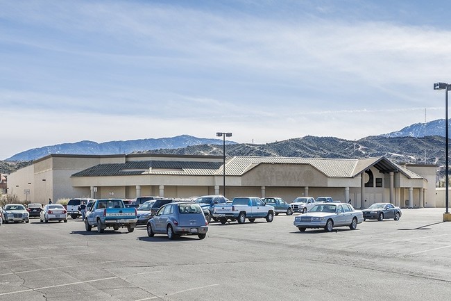
Storemultistory
GILA
AE The base floodplain where base flood elevations are provided. AE Zones are now used on new format FIRMs instead of A1-A30 Zones.
Arizona
2025
4.18 AC
2026
Arizona SE & Sierra Vista Area
000900
Other Market Areas
46,374 SF
Payson, AZ
NEARBY LISTINGS FOR SALE OR LEASE
-
-
View all Miami listings for sale on LoopNet.com
DEMOGRAPHICS near 2448 E Highway 60
1 mile
3 mile
5 mile
2025 Total Population
1,747
8,031
13,443
2030 Population
1,792
8,078
13,497
Pop Growth 2025-2030
+ 2.58%
+ 0.59%
+ 0.40%
Average Age
41
41
42
2025 Total Households
670
3,218
5,321
HH Growth 2025-2030
+ 2.09%
+ 0.19%
(0.06%)
Median Household Inc
$50,625
$49,193
$57,275
Avg Household Size
2.40
2.40
2.40
2025 Avg HH Vehicles
2.00
2.00
2.00
Median Home Value
$128,934
$154,479
$173,442
Median Year Built
1973
1972
1970
Nearby Places
Map Layers
Map Styles
 Street
 Aerial
Layers
 Traffic
 Biking
Places
Listings with unknown addresses are not visible on the map
- Restaurants
- Banks
- Shops
- Fitness
- Groceries
SALE & LEASE HISTORY
LISTING DATE
SALE/LEASE

Sep 25, 2016
For Lease
Sep 23, 2016
For Sale
Apr 20, 2023
For Sale
Apr 04, 2023
For Sale
Nearby Properties
Address
Land Use
TOTAL SIZE
Lot Size
Zoning
Address
Land Use
TOTAL SIZE
Lot Size
Zoning
130,074 SF
22.67 AC
Address
Land Use
TOTAL SIZE
Lot Size
Zoning
122,037 SF
59.39 AC
Address
Land Use
TOTAL SIZE
Lot Size
Zoning
480 SF
20.30 AC
Address
Land Use
TOTAL SIZE
Lot Size
Zoning
98,881 SF
13.12 AC
Address
Land Use
TOTAL SIZE
Lot Size
Zoning
67,395 SF
5.87 AC
Address
Land Use
TOTAL SIZE
Lot Size
Zoning
111,132 SF
10.15 AC
Address
Land Use
TOTAL SIZE
Lot Size
Zoning
62,672 SF
7.06 AC
Address
Land Use
TOTAL SIZE
Lot Size
Zoning
2.48 AC
Address
Land Use
TOTAL SIZE
Lot Size
Zoning
47,342 SF
5.31 AC
Address
Land Use
TOTAL SIZE
Lot Size
Zoning
240 SF
2.83 AC
Address
Land Use
TOTAL SIZE
Lot Size
Zoning
27,750 SF
3.71 AC
Address
Land Use
TOTAL SIZE
Lot Size
Zoning
38,688 SF
1.29 AC
Address
Land Use
TOTAL SIZE
Lot Size
Zoning
13,600 SF
2.53 AC
Address
Land Use
TOTAL SIZE
Lot Size
Zoning
23,428 SF
3.81 AC
Address
Land Use
TOTAL SIZE
Lot Size
Zoning
41,420 SF
0.89 AC
Address
Land Use
TOTAL SIZE
Lot Size
Zoning
25,128 SF
5.48 AC
Address
Land Use
TOTAL SIZE
Lot Size
Zoning
21,800 SF
20.99 AC
Address
Land Use
TOTAL SIZE
Lot Size
Zoning
12,000 SF
0.94 AC
Address
Land Use
TOTAL SIZE
Lot Size
Zoning
3,080 SF
1.09 AC
Address
Land Use
TOTAL SIZE
Lot Size
Zoning
14,048 SF
1.38 AC
Address
Land Use
TOTAL SIZE
Lot Size
Zoning
260 SF
1.57 AC
Address
Land Use
TOTAL SIZE
Lot Size
Zoning
48,852 SF
0.59 AC
Address
Land Use
TOTAL SIZE
Lot Size
Zoning
0.34 AC
Address
Land Use
TOTAL SIZE
Lot Size
Zoning
9,290 SF
1.76 AC
Address
Land Use
TOTAL SIZE
Lot Size
Zoning
19,396 SF
2.18 AC
Address
Land Use
TOTAL SIZE
Lot Size
Zoning
19,514 SF
4.09 AC
Address
Land Use
TOTAL SIZE
Lot Size
Zoning
252.08 AC
Address
Land Use
TOTAL SIZE
Lot Size
Zoning
29,060 SF
0.28 AC
Address
Land Use
TOTAL SIZE
Lot Size
Zoning
9,026 SF
1.38 AC
The World's #1 Commercial Real Estate Marketplace
Connect with us
© 2026 CoStar Group
The information above has been obtained from sources believed reliable. While we do not doubt its accuracy we have not verified it and make no guarantee, warranty or representation about it. It is your responsibility to independently confirm its accuracy and completeness. Any projections, opinions, assumptions, or estimates used are for example only and do not represent the current or future performance of the property. The value of this transaction to you depends on tax and other factors which should be evaluated by your tax, financial, and legal advisors. You and your advisors should conduct a careful, independent investigation of the property to determine to your satisfaction the suitability of the property for your needs.