Property Record
2449 Baseline Ave, Solvang, CA 93463
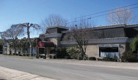

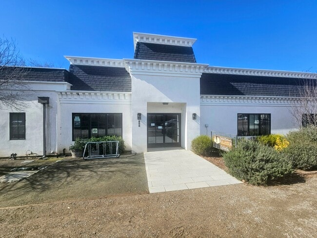

Property Detail
2449 Baseline Ave
Santa Maria-Santa Barbara, CA
TR 11281 LOT 11 BLK 4
137-051-004
SANTA BARBARA
Restaurantbuilding
California
CN
11
C and X Area of minimal flood hazard, usually depicted on FIRMs as above the 500-year flood level.
0.44 AC
2024
Central SB County
2025
Santa Barbara/Sta Maria/Goleta
001905
NEARBY LISTINGS FOR SALE OR LEASE
-
-
View all Solvang listings for lease on LoopNet.com
DEMOGRAPHICS near 2449 Baseline Ave
1 mile
3 mile
5 mile
2025 Total Population
579
8,925
15,767
2030 Population
532
8,454
15,063
Pop Growth 2025-2030
(8.12%)
(5.28%)
(4.47%)
Average Age
46
47
45
2025 Total Households
215
3,438
6,094
HH Growth 2025-2030
(8.37%)
(5.47%)
(4.66%)
Median Household Inc
$121,634
$120,370
$117,424
Avg Household Size
2.60
2.50
2.50
2025 Avg HH Vehicles
3.00
2.00
2.00
Median Home Value
$1,121,374
$1,093,697
$1,053,475
Median Year Built
1975
1978
1980
Nearby Places
Map Layers
Map Styles
 Street
 Aerial
Transit
 Traffic
 Biking
Places
Listings with unknown addresses are not visible on the map
- Restaurants
- Banks
- Shops
- Fitness
- Groceries
PUBLIC TRANSPORTATION
AIRPORT
Santa Barbara Municipal
Drive
Walk
Distance
Santa Barbara Municipal
64 min
36.0 mi
Freight Ports
The Port of Hueneme
Drive
Walk
Distance
The Port of Hueneme
99 min
72.1 mi
SALE & LEASE HISTORY
LISTING DATE
SALE/LEASE

Sep 25, 2016
For Lease
Sep 23, 2016
For Sale
May 09, 2023
For Lease
Feb 06, 2025
For Lease
Nearby Properties
Address
Land Use
TOTAL SIZE
Lot Size
Zoning
Address
Land Use
TOTAL SIZE
Lot Size
Zoning
5.10 AC
Address
Land Use
TOTAL SIZE
Lot Size
Zoning
5.43 AC
Address
Land Use
TOTAL SIZE
Lot Size
Zoning
10.27 AC
Address
Land Use
TOTAL SIZE
Lot Size
Zoning
14,794 SF
34.82 AC
AGII40
Address
Land Use
TOTAL SIZE
Lot Size
Zoning
46.18 AC
AGI10
Address
Land Use
TOTAL SIZE
Lot Size
Zoning
18.16 AC
AGI40
Address
Land Use
TOTAL SIZE
Lot Size
Zoning
4.35 AC
C2
Address
Land Use
TOTAL SIZE
Lot Size
Zoning
6,332 SF
24.44 AC
AGI20
Address
Land Use
TOTAL SIZE
Lot Size
Zoning
4,912 SF
65.81 AC
AGI40
Address
Land Use
TOTAL SIZE
Lot Size
Zoning
3.08 AC
Address
Land Use
TOTAL SIZE
Lot Size
Zoning
3.34 AC
Address
Land Use
TOTAL SIZE
Lot Size
Zoning
148.18 AC
AGII100
Address
Land Use
TOTAL SIZE
Lot Size
Zoning
15.19 AC
AGI10
Address
Land Use
TOTAL SIZE
Lot Size
Zoning
37.06 AC
AGI40
Address
Land Use
TOTAL SIZE
Lot Size
Zoning
445.97 AC
AGII100
Address
Land Use
TOTAL SIZE
Lot Size
Zoning
5,093 SF
40 AC
AGII40
Address
Land Use
TOTAL SIZE
Lot Size
Zoning
1,190 SF
52.62 AC
AGII40
Address
Land Use
TOTAL SIZE
Lot Size
Zoning
0.86 AC
Address
Land Use
TOTAL SIZE
Lot Size
Zoning
9,864 SF
250.68 AC
AGII100
Address
Land Use
TOTAL SIZE
Lot Size
Zoning
2.62 AC
1E1
Address
Land Use
TOTAL SIZE
Lot Size
Zoning
214.81 AC
AGII100
Address
Land Use
TOTAL SIZE
Lot Size
Zoning
0.46 AC
C2
Address
Land Use
TOTAL SIZE
Lot Size
Zoning
9,062 SF
0.52 AC
C2
Address
Land Use
TOTAL SIZE
Lot Size
Zoning
Address
Land Use
TOTAL SIZE
Lot Size
Zoning
219.26 AC
AGII100
Address
Land Use
TOTAL SIZE
Lot Size
Zoning
5,900 SF
21.69 AC
AGI20
Address
Land Use
TOTAL SIZE
Lot Size
Zoning
0.28 AC
Address
Land Use
TOTAL SIZE
Lot Size
Zoning
4,178 SF
10.45 AC
AGI10
Address
Land Use
TOTAL SIZE
Lot Size
Zoning
39,204 SF
1.15 AC
C2
The World's #1 Commercial Real Estate Marketplace
Connect with us
© 2026 CoStar Group
The information above has been obtained from sources believed reliable. While we do not doubt its accuracy we have not verified it and make no guarantee, warranty or representation about it. It is your responsibility to independently confirm its accuracy and completeness. Any projections, opinions, assumptions, or estimates used are for example only and do not represent the current or future performance of the property. The value of this transaction to you depends on tax and other factors which should be evaluated by your tax, financial, and legal advisors. You and your advisors should conduct a careful, independent investigation of the property to determine to your satisfaction the suitability of the property for your needs.