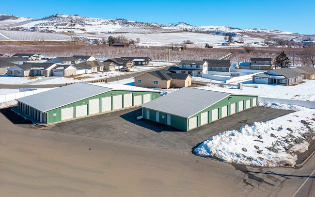
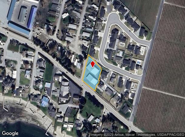
Property Record
2449 State Route 150, Manson, WA 98831

NEARBY LISTINGS FOR SALE OR LEASE
-
-
View all Manson listings for sale on LoopNet.com
Property Detail
2449 State Route 150
Other Market Areas
Low Line No 1
Wenatchee, WA
LOW LINE NO 1 LOT 88 LOT B BLA 2018-021 0.7000 ACRES LOT B BLA 2018-021
50749
Chelan
Commercialnec
Washington
2024
88
2024
0.70 AC
960400
Washington State Area
8,800 SF
DEMOGRAPHICS near 2449 State Route 150
1 Mile
3 Mile
5 Mile
2024 Total Population
449
3,913
7,303
2029 Population
449
4,043
7,611
Pop Growth 2024-2029
0.00%
+ 3.32%
+ 4.22%
Average Age
43
46
46
2024 Total Households
167
1,594
2,949
HH Growth 2024-2029
(0.60%)
+ 3.58%
+ 4.44%
Median Household Inc
$61,250
$61,859
$66,859
Avg Household Size
2.60
2.40
2.40
2024 Avg HH Vehicles
2.00
2.00
2.00
Median Home Value
$479,999
$622,758
$653,333
Median Year Built
1992
1990
1989
Nearby Places
Map Layers
Map Styles
 Street
 Aerial
- Restaurants
- Banks
- Shops
- Fitness
- Groceries
SALE & LEASE HISTORY
LISTING DATE
SALE/LEASE

Apr 11, 2022
For Sale
Nearby Properties
Address
Land Use
TOTAL SIZE
Lot Size
Zoning
Address
Land Use
TOTAL SIZE
Lot Size
Zoning
73,440 SF
5 AC
Address
Land Use
TOTAL SIZE
Lot Size
Zoning
26,964 SF
1.67 AC
Address
Land Use
TOTAL SIZE
Lot Size
Zoning
48,532 SF
5.41 AC
Address
Land Use
TOTAL SIZE
Lot Size
Zoning
60,728 SF
10.14 AC
Address
Land Use
TOTAL SIZE
Lot Size
Zoning
49,540 SF
4.35 AC
Address
Land Use
TOTAL SIZE
Lot Size
Zoning
16,720 SF
3.34 AC
Address
Land Use
TOTAL SIZE
Lot Size
Zoning
33,660 SF
1.56 AC
Address
Land Use
TOTAL SIZE
Lot Size
Zoning
6,021 SF
13.40 AC
Address
Land Use
TOTAL SIZE
Lot Size
Zoning
10,211 SF
28.04 AC
Address
Land Use
TOTAL SIZE
Lot Size
Zoning
5,318 SF
390.59 AC
Address
Land Use
TOTAL SIZE
Lot Size
Zoning
27,810 SF
2.68 AC
Address
Land Use
TOTAL SIZE
Lot Size
Zoning
12,840 SF
1.26 AC
Address
Land Use
TOTAL SIZE
Lot Size
Zoning
16,294 SF
50 AC
Address
Land Use
TOTAL SIZE
Lot Size
Zoning
23,485 SF
3.02 AC
Address
Land Use
TOTAL SIZE
Lot Size
Zoning
4,704 SF
0.41 AC
Address
Land Use
TOTAL SIZE
Lot Size
Zoning
7,688 SF
158.19 AC
Address
Land Use
TOTAL SIZE
Lot Size
Zoning
13,312 SF
5.80 AC
Address
Land Use
TOTAL SIZE
Lot Size
Zoning
3,299 SF
11.22 AC
Address
Land Use
TOTAL SIZE
Lot Size
Zoning
5,612 SF
0.77 AC
Address
Land Use
TOTAL SIZE
Lot Size
Zoning
5,612 SF
0.70 AC
Address
Land Use
TOTAL SIZE
Lot Size
Zoning
12,000 SF
0.80 AC
Address
Land Use
TOTAL SIZE
Lot Size
Zoning
4,144 SF
10.13 AC
Address
Land Use
TOTAL SIZE
Lot Size
Zoning
6,410 SF
20.40 AC
Address
Land Use
TOTAL SIZE
Lot Size
Zoning
6,484 SF
1.34 AC
Address
Land Use
TOTAL SIZE
Lot Size
Zoning
3,088 SF
99.10 AC
Address
Land Use
TOTAL SIZE
Lot Size
Zoning
4.97 AC
Address
Land Use
TOTAL SIZE
Lot Size
Zoning
3,072 SF
2 AC
Address
Land Use
TOTAL SIZE
Lot Size
Zoning
91.23 AC
Address
Land Use
TOTAL SIZE
Lot Size
Zoning
8,462 SF
2.70 AC
Address
Land Use
TOTAL SIZE
Lot Size
Zoning
27,120 SF
1.14 AC
The World's #1 Commercial Real Estate Marketplace
Connect with us
© 2026 CoStar Group
The information above has been obtained from sources believed reliable. While we do not doubt its accuracy we have not verified it and make no guarantee, warranty or representation about it. It is your responsibility to independently confirm its accuracy and completeness. Any projections, opinions, assumptions, or estimates used are for example only and do not represent the current or future performance of the property. The value of this transaction to you depends on tax and other factors which should be evaluated by your tax, financial, and legal advisors. You and your advisors should conduct a careful, independent investigation of the property to determine to your satisfaction the suitability of the property for your needs.