Property Record
24496 80Th Ave N, Hawley, MN 56549
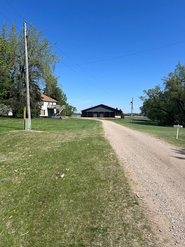


This Property Is For Sale
Current Lease Availabilities
NEARBY LISTINGS FOR SALE OR LEASE
Property Detail
24496 80Th Ave N
14-006-3801
BEG. 2384.88' E OF SW COR OF SEC. 6; E 40.04'; N 1688.87'; ETC. 6-140-44 SECTION 06 TOWNSHIP 140 RANGE 044
Realpropertynec
Clay
X
Minnesota
27027C0425E
10 AC
2025
Fargo
2025
Other Market Areas
030201
Fargo, ND-MN
DEMOGRAPHICS near 24496 80Th Ave N
1 Mile
3 Mile
5 Mile
2024 Total Population
21
341
710
2029 Population
21
336
702
Pop Growth 2024-2029
0.00%
(1.47%)
(1.13%)
Average Age
43
42
42
2024 Total Households
8
132
267
HH Growth 2024-2029
0.00%
(1.52%)
(1.12%)
Median Household Inc
$99,999
$65,454
$72,499
Avg Household Size
2.50
2.50
2.50
2024 Avg HH Vehicles
3.00
2.00
2.00
Median Home Value
$274,999
$242,000
$258,490
Median Year Built
1972
1970
1971
Nearby Places
Map Layers
Map Styles
 Street
 Aerial
- Restaurants
- Banks
- Shops
- Fitness
- Groceries
PUBLIC TRANSPORTATION
AIRPORT
Hector International
DRIVE
WALK
Distance
Hector International
59 min
34.4 mi
Nearby Properties
Address
Land Use
TOTAL SIZE
Lot Size
Zoning
Address
Land Use
TOTAL SIZE
Lot Size
Zoning
320 AC
Address
Land Use
TOTAL SIZE
Lot Size
Zoning
312.57 AC
Address
Land Use
TOTAL SIZE
Lot Size
Zoning
283.15 AC
Address
Land Use
TOTAL SIZE
Lot Size
Zoning
200 AC
Address
Land Use
TOTAL SIZE
Lot Size
Zoning
255.60 AC
Address
Land Use
TOTAL SIZE
Lot Size
Zoning
298.48 AC
Address
Land Use
TOTAL SIZE
Lot Size
Zoning
118.90 AC
Address
Land Use
TOTAL SIZE
Lot Size
Zoning
152.45 AC
Address
Land Use
TOTAL SIZE
Lot Size
Zoning
234.62 AC
Address
Land Use
TOTAL SIZE
Lot Size
Zoning
280 AC
Address
Land Use
TOTAL SIZE
Lot Size
Zoning
192.71 AC
Address
Land Use
TOTAL SIZE
Lot Size
Zoning
149.03 AC
Address
Land Use
TOTAL SIZE
Lot Size
Zoning
133.50 AC
Address
Land Use
TOTAL SIZE
Lot Size
Zoning
138.44 AC
Address
Land Use
TOTAL SIZE
Lot Size
Zoning
21.52 AC
Address
Land Use
TOTAL SIZE
Lot Size
Zoning
160 AC
Address
Land Use
TOTAL SIZE
Lot Size
Zoning
171.58 AC
Address
Land Use
TOTAL SIZE
Lot Size
Zoning
190.87 AC
Address
Land Use
TOTAL SIZE
Lot Size
Zoning
133.45 AC
Address
Land Use
TOTAL SIZE
Lot Size
Zoning
138.44 AC
Address
Land Use
TOTAL SIZE
Lot Size
Zoning
Address
Land Use
TOTAL SIZE
Lot Size
Zoning
150.63 AC
Address
Land Use
TOTAL SIZE
Lot Size
Zoning
168.14 AC
Address
Land Use
TOTAL SIZE
Lot Size
Zoning
154.53 AC
Address
Land Use
TOTAL SIZE
Lot Size
Zoning
45.69 AC
Address
Land Use
TOTAL SIZE
Lot Size
Zoning
153.37 AC
Address
Land Use
TOTAL SIZE
Lot Size
Zoning
11.36 AC
Address
Land Use
TOTAL SIZE
Lot Size
Zoning
109.31 AC
Address
Land Use
TOTAL SIZE
Lot Size
Zoning
14.68 AC
The World's #1 Commercial Real Estate Marketplace
Connect with us
© 2025 CoStar Group
The information above has been obtained from sources believed reliable. While we do not doubt its accuracy we have not verified it and make no guarantee, warranty or representation about it. It is your responsibility to independently confirm its accuracy and completeness. Any projections, opinions, assumptions, or estimates used are for example only and do not represent the current or future performance of the property. The value of this transaction to you depends on tax and other factors which should be evaluated by your tax, financial, and legal advisors. You and your advisors should conduct a careful, independent investigation of the property to determine to your satisfaction the suitability of the property for your needs.