Property Record
245 Center Dr, Orrington, ME 04474
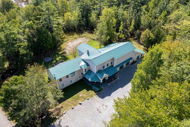
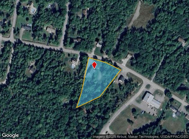
This Property Is For Sale
NEARBY LISTINGS FOR SALE OR LEASE
-
-
View all Orrington listings for sale on LoopNet.com
Property Detail
245 Center Dr
Bangor, ME
Penobscot
ORRI M:005 L:107-B
Maine
Sfr
1.20 AC
X
Maine North & Bangor
23019C2306D
Other Market Areas
DEMOGRAPHICS near 245 Center Dr
1 Mile
3 Mile
5 Mile
2024 Total Population
536
7,255
17,292
2029 Population
540
7,339
17,372
Pop Growth 2024-2029
+ 0.75%
+ 1.16%
+ 0.46%
Average Age
45
44
44
2024 Total Households
216
2,969
7,329
HH Growth 2024-2029
+ 0.93%
+ 1.35%
+ 0.56%
Median Household Inc
$111,931
$101,318
$85,483
Avg Household Size
2.40
2.30
2.30
2024 Avg HH Vehicles
2.00
2.00
2.00
Median Home Value
$331,034
$312,863
$288,250
Median Year Built
1976
1982
1972
Nearby Places
- Restaurants
- Banks
- Shops
- Fitness
- Groceries
PUBLIC TRANSPORTATION
AIRPORT
Bangor International
DRIVE
WALK
Distance
Bangor International
21 min
10.7 mi
Freight Ports
Searsport, ME
DRIVE
WALK
Distance
Searsport, ME
43 min
25.6 mi
Nearby Properties
Address
Land Use
TOTAL SIZE
Lot Size
Zoning
Address
Land Use
TOTAL SIZE
Lot Size
Zoning
Address
Land Use
TOTAL SIZE
Lot Size
Zoning
54,122 SF
82.18 AC
12 - R
Address
Land Use
TOTAL SIZE
Lot Size
Zoning
34.50 AC
Address
Land Use
TOTAL SIZE
Lot Size
Zoning
Address
Land Use
TOTAL SIZE
Lot Size
Zoning
61,870 SF
9.20 AC
12 - R
Address
Land Use
TOTAL SIZE
Lot Size
Zoning
Address
Land Use
TOTAL SIZE
Lot Size
Zoning
18,744 SF
43.50 AC
12 - R
Address
Land Use
TOTAL SIZE
Lot Size
Zoning
20,247 SF
7.87 AC
22 - B
Address
Land Use
TOTAL SIZE
Lot Size
Zoning
Address
Land Use
TOTAL SIZE
Lot Size
Zoning
25,988 SF
2.45 AC
20 - T
Address
Land Use
TOTAL SIZE
Lot Size
Zoning
28,600 SF
4 AC
22 - B
Address
Land Use
TOTAL SIZE
Lot Size
Zoning
14,630 SF
4.27 AC
22 - B
Address
Land Use
TOTAL SIZE
Lot Size
Zoning
17,980 SF
4 AC
12 - R
Address
Land Use
TOTAL SIZE
Lot Size
Zoning
22,848 SF
5.80 AC
12 - R
Address
Land Use
TOTAL SIZE
Lot Size
Zoning
9,795 SF
5.10 AC
12 - R
Address
Land Use
TOTAL SIZE
Lot Size
Zoning
12,487 SF
2.43 AC
12 - R
Address
Land Use
TOTAL SIZE
Lot Size
Zoning
6,599 SF
10.39 AC
21 - B
Address
Land Use
TOTAL SIZE
Lot Size
Zoning
Address
Land Use
TOTAL SIZE
Lot Size
Zoning
Address
Land Use
TOTAL SIZE
Lot Size
Zoning
792 SF
2.13 AC
12 - R
Address
Land Use
TOTAL SIZE
Lot Size
Zoning
2.74 AC
Address
Land Use
TOTAL SIZE
Lot Size
Zoning
1.08 AC
RT 15
Address
Land Use
TOTAL SIZE
Lot Size
Zoning
29,440 SF
6.76 AC
33 - C
Address
Land Use
TOTAL SIZE
Lot Size
Zoning
3,080 SF
3.33 AC
22 - B
Address
Land Use
TOTAL SIZE
Lot Size
Zoning
19,112 SF
43 AC
33 - C
Address
Land Use
TOTAL SIZE
Lot Size
Zoning
1.19 AC
Address
Land Use
TOTAL SIZE
Lot Size
Zoning
11,800 SF
2.44 AC
11 - R
Address
Land Use
TOTAL SIZE
Lot Size
Zoning
2,752 SF
3.50 AC
22 - B
Address
Land Use
TOTAL SIZE
Lot Size
Zoning
12.34 AC
Address
Land Use
TOTAL SIZE
Lot Size
Zoning
6,900 SF
23.29 AC
33 - C
The World's #1 Commercial Real Estate Marketplace
Connect with us
© 2025 CoStar Group
The information above has been obtained from sources believed reliable. While we do not doubt its accuracy we have not verified it and make no guarantee, warranty or representation about it. It is your responsibility to independently confirm its accuracy and completeness. Any projections, opinions, assumptions, or estimates used are for example only and do not represent the current or future performance of the property. The value of this transaction to you depends on tax and other factors which should be evaluated by your tax, financial, and legal advisors. You and your advisors should conduct a careful, independent investigation of the property to determine to your satisfaction the suitability of the property for your needs.