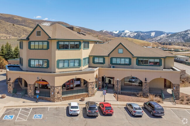
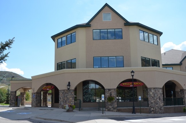
Property Record
245 Chapel Pl, Avon, CO 81620


Property Detail
245 Chapel Pl
Edwards, CO
SUBDIVISION: CHAPEL SQUARE SUBDIVISION LOT: 22-AB R927865 MAP 08-30-05 R937485 SWD 11-11-05
R056997
EAGLE
Officebuilding
Colorado
B and X Area of moderate flood hazard, usually the area between the limits of the 100-year and 500-year floods.
22ab
2024
1.52 AC
2025
Colorado Ski Area
000504
Other Market Areas
36,660 SF
NEARBY LISTINGS FOR SALE OR LEASE
DEMOGRAPHICS near 245 Chapel Pl
1 mile
3 mile
5 mile
2024 Total Population
3,194
8,693
14,472
2029 Population
3,017
8,190
13,867
Pop Growth 2024-2029
(5.54%)
(5.79%)
(4.18%)
Average Age
37
39
39
2024 Total Households
1,259
3,307
5,582
HH Growth 2024-2029
(6.51%)
(6.74%)
(4.94%)
Median Household Inc
$87,643
$88,474
$97,523
Avg Household Size
2.50
2.50
2.50
2024 Avg HH Vehicles
2.00
2.00
2.00
Median Home Value
$586,382
$775,561
$785,168
Median Year Built
1988
1990
1991
Nearby Places
Map Layers
Map Styles
 Street
 Aerial
Transit
 Traffic
 Biking
Places
Listings with unknown addresses are not visible on the map
- Restaurants
- Banks
- Shops
- Fitness
- Groceries
PUBLIC TRANSPORTATION
AIRPORT
Eagle County Regional
Drive
Walk
Distance
Eagle County Regional
33 min
26.5 mi
Freight Ports
Tulsa Port Of Catoosa
Drive
Walk
Distance
Tulsa Port Of Catoosa
855 min
815.5 mi
SALE & LEASE HISTORY
LISTING DATE
SALE/LEASE

Jan 11, 2017
For Lease
Nearby Properties
Address
Land Use
TOTAL SIZE
Lot Size
Zoning
Address
Land Use
TOTAL SIZE
Lot Size
Zoning
201,683 SF
1.75 AC
Address
Land Use
TOTAL SIZE
Lot Size
Zoning
121,897 SF
2.95 AC
Address
Land Use
TOTAL SIZE
Lot Size
Zoning
133,741 SF
4.53 AC
Address
Land Use
TOTAL SIZE
Lot Size
Zoning
7.38 AC
Address
Land Use
TOTAL SIZE
Lot Size
Zoning
75,203 SF
2.07 AC
Address
Land Use
TOTAL SIZE
Lot Size
Zoning
126,332 SF
0.92 AC
Address
Land Use
TOTAL SIZE
Lot Size
Zoning
282,869 SF
10 AC
Address
Land Use
TOTAL SIZE
Lot Size
Zoning
188,516 SF
13.52 AC
Address
Land Use
TOTAL SIZE
Lot Size
Zoning
83,253 SF
2.78 AC
Address
Land Use
TOTAL SIZE
Lot Size
Zoning
53,616 SF
0.76 AC
Address
Land Use
TOTAL SIZE
Lot Size
Zoning
150,158 SF
9.67 AC
Address
Land Use
TOTAL SIZE
Lot Size
Zoning
42,482 SF
800.12 AC
Address
Land Use
TOTAL SIZE
Lot Size
Zoning
2,610 SF
2.21 AC
Address
Land Use
TOTAL SIZE
Lot Size
Zoning
49,228 SF
9.88 AC
Address
Land Use
TOTAL SIZE
Lot Size
Zoning
19,804 SF
0.50 AC
Address
Land Use
TOTAL SIZE
Lot Size
Zoning
64,698 SF
2.86 AC
Address
Land Use
TOTAL SIZE
Lot Size
Zoning
16,206 SF
0.37 AC
Address
Land Use
TOTAL SIZE
Lot Size
Zoning
42,017 SF
1.41 AC
Address
Land Use
TOTAL SIZE
Lot Size
Zoning
15.73 AC
Address
Land Use
TOTAL SIZE
Lot Size
Zoning
18,725 SF
0.17 AC
Address
Land Use
TOTAL SIZE
Lot Size
Zoning
67,452 SF
9.18 AC
Address
Land Use
TOTAL SIZE
Lot Size
Zoning
18,614 SF
2.23 AC
Address
Land Use
TOTAL SIZE
Lot Size
Zoning
11,287 SF
1.22 AC
Address
Land Use
TOTAL SIZE
Lot Size
Zoning
Address
Land Use
TOTAL SIZE
Lot Size
Zoning
12,553 SF
1.38 AC
Address
Land Use
TOTAL SIZE
Lot Size
Zoning
44,220 SF
157.48 AC
Address
Land Use
TOTAL SIZE
Lot Size
Zoning
61,168 SF
165.88 AC
Address
Land Use
TOTAL SIZE
Lot Size
Zoning
34,115 SF
2.11 AC
Address
Land Use
TOTAL SIZE
Lot Size
Zoning
98,496 SF
7.57 AC
The World's #1 Commercial Real Estate Marketplace
Connect with us
© 2026 CoStar Group
The information above has been obtained from sources believed reliable. While we do not doubt its accuracy we have not verified it and make no guarantee, warranty or representation about it. It is your responsibility to independently confirm its accuracy and completeness. Any projections, opinions, assumptions, or estimates used are for example only and do not represent the current or future performance of the property. The value of this transaction to you depends on tax and other factors which should be evaluated by your tax, financial, and legal advisors. You and your advisors should conduct a careful, independent investigation of the property to determine to your satisfaction the suitability of the property for your needs.