Property Record
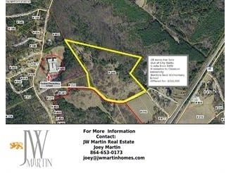
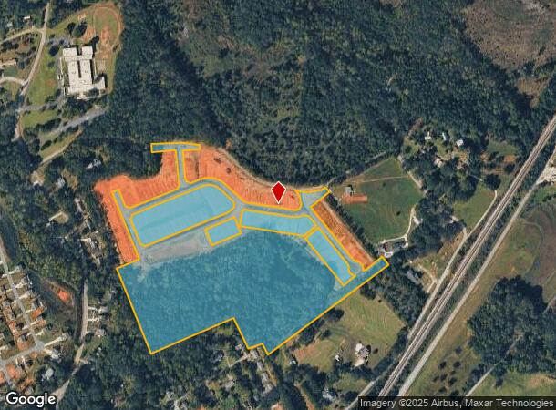
245 Lawton Rd, Central, SC 29630
NEARBY LISTINGS FOR SALE OR LEASE
-
-
View all Central listings for sale on LoopNet.com
Property Detail
245 Lawton Rd
4065-08-79-5636
S/SIDE LAWTON RD PART OF PLAT 61/61A PLAT 597/347 PLAT 599/33 PLAT 609/34
Vacantlandnec
Pickens
X
South Carolina
45007C0085E
46.14 AC
2024
Outlying Pickens County
2024
Greenville/Spartanburg
011101
Greenville-Anderson-Greer, SC
1,138 SF
DEMOGRAPHICS near 245 Lawton Rd
1 Mile
3 Mile
5 Mile
2024 Total Population
1,788
11,131
31,544
2029 Population
1,861
11,495
32,592
Pop Growth 2024-2029
+ 4.08%
+ 3.27%
+ 3.32%
Average Age
37
35
36
2024 Total Households
668
4,655
12,801
HH Growth 2024-2029
+ 4.04%
+ 3.39%
+ 3.44%
Median Household Inc
$36,104
$33,446
$42,066
Avg Household Size
2.30
2.30
2.30
2024 Avg HH Vehicles
2.00
2.00
2.00
Median Home Value
$175,640
$164,896
$221,365
Median Year Built
1978
1989
1990
Nearby Places
Map Layers
Map Styles
 Street
 Aerial
- Restaurants
- Banks
- Shops
- Fitness
- Groceries
PUBLIC TRANSPORTATION
COMMUTER RAIL
Clemson Amtrak Station (Crescent - Amtrak)
DRIVE
WALK
Distance
Clemson Amtrak Station (Crescent - Amtrak)
12 min
5.7 mi
Freight Ports
Georgia Ports - Savannah
DRIVE
WALK
Distance
Georgia Ports - Savannah
326 min
278.8 mi
Nearby Properties
Address
Land Use
TOTAL SIZE
Lot Size
Zoning
Address
Land Use
TOTAL SIZE
Lot Size
Zoning
5,208 SF
11.33 AC
RM16
Address
Land Use
TOTAL SIZE
Lot Size
Zoning
4,688 SF
10.93 AC
RM 3 MULTI
Address
Land Use
TOTAL SIZE
Lot Size
Zoning
3,160 SF
2.30 AC
RM16 RESID
Address
Land Use
TOTAL SIZE
Lot Size
Zoning
103.43 AC
Address
Land Use
TOTAL SIZE
Lot Size
Zoning
7,070 SF
2.59 AC
GENERAL CO
Address
Land Use
TOTAL SIZE
Lot Size
Zoning
17 AC
RIL RESEAR
Address
Land Use
TOTAL SIZE
Lot Size
Zoning
11,881 SF
2.02 AC
GENERAL CO
Address
Land Use
TOTAL SIZE
Lot Size
Zoning
20,686 SF
15.84 AC
RM16
Address
Land Use
TOTAL SIZE
Lot Size
Zoning
10.09 AC
GC
Address
Land Use
TOTAL SIZE
Lot Size
Zoning
249,600 SF
12.61 AC
RM16
Address
Land Use
TOTAL SIZE
Lot Size
Zoning
20,927 SF
2.66 AC
GC
Address
Land Use
TOTAL SIZE
Lot Size
Zoning
17,592 SF
10.67 AC
RM16 RESID
Address
Land Use
TOTAL SIZE
Lot Size
Zoning
196,017 SF
25.24 AC
GC
Address
Land Use
TOTAL SIZE
Lot Size
Zoning
6,377 SF
2.01 AC
GC
Address
Land Use
TOTAL SIZE
Lot Size
Zoning
14,868 SF
5.22 AC
PDD
Address
Land Use
TOTAL SIZE
Lot Size
Zoning
3,770 SF
10.02 AC
RM16
Address
Land Use
TOTAL SIZE
Lot Size
Zoning
1,172 SF
10.25 AC
Address
Land Use
TOTAL SIZE
Lot Size
Zoning
68,705 SF
1.21 AC
UD
Address
Land Use
TOTAL SIZE
Lot Size
Zoning
64.70 AC
UD
Address
Land Use
TOTAL SIZE
Lot Size
Zoning
3,542 SF
1.62 AC
GENERAL CO
Address
Land Use
TOTAL SIZE
Lot Size
Zoning
3,542 SF
0.80 AC
GC
Address
Land Use
TOTAL SIZE
Lot Size
Zoning
2,698 SF
11.75 AC
CP 2 COMMU
Address
Land Use
TOTAL SIZE
Lot Size
Zoning
5,000 SF
1.47 AC
GENERAL CO
Address
Land Use
TOTAL SIZE
Lot Size
Zoning
9 AC
R 20 SINGL
Address
Land Use
TOTAL SIZE
Lot Size
Zoning
113,571 SF
8.48 AC
RM 4 MULTI
Address
Land Use
TOTAL SIZE
Lot Size
Zoning
16.52 AC
Address
Land Use
TOTAL SIZE
Lot Size
Zoning
1,200 SF
2.99 AC
GENERAL CO
Address
Land Use
TOTAL SIZE
Lot Size
Zoning
35,280 SF
6.04 AC
GC
Address
Land Use
TOTAL SIZE
Lot Size
Zoning
2,259 SF
2.05 AC
GENERAL CO
Address
Land Use
TOTAL SIZE
Lot Size
Zoning
80,019 SF
10.19 AC
RM 4 MULTI
The World's #1 Commercial Real Estate Marketplace
Connect with us
© 2026 CoStar Group
The information above has been obtained from sources believed reliable. While we do not doubt its accuracy we have not verified it and make no guarantee, warranty or representation about it. It is your responsibility to independently confirm its accuracy and completeness. Any projections, opinions, assumptions, or estimates used are for example only and do not represent the current or future performance of the property. The value of this transaction to you depends on tax and other factors which should be evaluated by your tax, financial, and legal advisors. You and your advisors should conduct a careful, independent investigation of the property to determine to your satisfaction the suitability of the property for your needs.