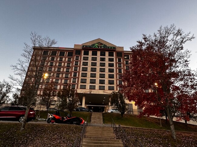
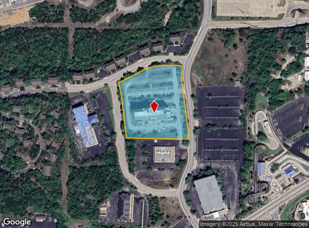
Property Record
245 N Wildwood Dr, Branson, MO 65616
NEARBY LISTINGS FOR SALE OR LEASE
Property Detail
245 N Wildwood Dr
Branson, MO
Oak Creek Subdivision
18-1.0-01-002-002-005.004
OAK CREEK LTS 9 & 10 REPLAT LTS 8, 9 & 10; CITY OF
Commercialnec
Taney
X
Missouri
29209C0225D
9-10
2024
3.87 AC
2025
Branson
480106
Other Market Areas
12,542 SF
DEMOGRAPHICS near 245 N Wildwood Dr
1 Mile
3 Mile
5 Mile
2024 Total Population
2,730
18,664
33,776
2029 Population
2,936
19,453
35,300
Pop Growth 2024-2029
+ 7.55%
+ 4.23%
+ 4.51%
Average Age
42
41
42
2024 Total Households
1,234
7,437
14,031
HH Growth 2024-2029
+ 7.46%
+ 4.41%
+ 4.67%
Median Household Inc
$50,207
$51,870
$53,245
Avg Household Size
2.20
2.20
2.20
2024 Avg HH Vehicles
2.00
2.00
2.00
Median Home Value
$158,532
$175,810
$180,142
Median Year Built
1997
1995
1996
Nearby Places
Map Layers
Map Styles
 Street
 Aerial
- Restaurants
- Banks
- Shops
- Fitness
- Groceries
SALE & LEASE HISTORY
LISTING DATE
SALE/LEASE

Feb 01, 2024
For Sale
Nearby Properties
Address
Land Use
TOTAL SIZE
Lot Size
Zoning
Address
Land Use
TOTAL SIZE
Lot Size
Zoning
107,469 SF
21.35 AC
Address
Land Use
TOTAL SIZE
Lot Size
Zoning
50,417 SF
17.43 AC
Address
Land Use
TOTAL SIZE
Lot Size
Zoning
350,270 SF
40 AC
Address
Land Use
TOTAL SIZE
Lot Size
Zoning
140,093 SF
8.37 AC
Address
Land Use
TOTAL SIZE
Lot Size
Zoning
Address
Land Use
TOTAL SIZE
Lot Size
Zoning
26,658 SF
6.30 AC
Address
Land Use
TOTAL SIZE
Lot Size
Zoning
43,276 SF
5.93 AC
Address
Land Use
TOTAL SIZE
Lot Size
Zoning
18,781 SF
4.70 AC
Address
Land Use
TOTAL SIZE
Lot Size
Zoning
135,214 SF
13.91 AC
Address
Land Use
TOTAL SIZE
Lot Size
Zoning
63,890 SF
14.45 AC
Address
Land Use
TOTAL SIZE
Lot Size
Zoning
27,496 SF
3.34 AC
Address
Land Use
TOTAL SIZE
Lot Size
Zoning
32,464 SF
2.16 AC
Address
Land Use
TOTAL SIZE
Lot Size
Zoning
19,872 SF
2.97 AC
Address
Land Use
TOTAL SIZE
Lot Size
Zoning
45,680 SF
11.85 AC
Address
Land Use
TOTAL SIZE
Lot Size
Zoning
25,760 SF
6.47 AC
Address
Land Use
TOTAL SIZE
Lot Size
Zoning
55,651 SF
3.95 AC
Address
Land Use
TOTAL SIZE
Lot Size
Zoning
85,644 SF
6.64 AC
Address
Land Use
TOTAL SIZE
Lot Size
Zoning
53,728 SF
6.74 AC
Address
Land Use
TOTAL SIZE
Lot Size
Zoning
17,313 SF
5.18 AC
Address
Land Use
TOTAL SIZE
Lot Size
Zoning
48,182 SF
15 AC
Address
Land Use
TOTAL SIZE
Lot Size
Zoning
51,842 SF
3.48 AC
Address
Land Use
TOTAL SIZE
Lot Size
Zoning
44,871 SF
4.57 AC
Address
Land Use
TOTAL SIZE
Lot Size
Zoning
1,804,046 SF
23.86 AC
Address
Land Use
TOTAL SIZE
Lot Size
Zoning
51,904 SF
5.08 AC
Address
Land Use
TOTAL SIZE
Lot Size
Zoning
28,639 SF
2.51 AC
Address
Land Use
TOTAL SIZE
Lot Size
Zoning
18,330 SF
2.80 AC
Address
Land Use
TOTAL SIZE
Lot Size
Zoning
10,860 SF
0.29 AC
Address
Land Use
TOTAL SIZE
Lot Size
Zoning
39,644 SF
7.02 AC
The World's #1 Commercial Real Estate Marketplace
Connect with us
© 2026 CoStar Group
The information above has been obtained from sources believed reliable. While we do not doubt its accuracy we have not verified it and make no guarantee, warranty or representation about it. It is your responsibility to independently confirm its accuracy and completeness. Any projections, opinions, assumptions, or estimates used are for example only and do not represent the current or future performance of the property. The value of this transaction to you depends on tax and other factors which should be evaluated by your tax, financial, and legal advisors. You and your advisors should conduct a careful, independent investigation of the property to determine to your satisfaction the suitability of the property for your needs.