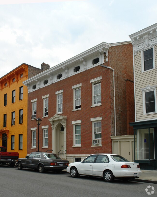
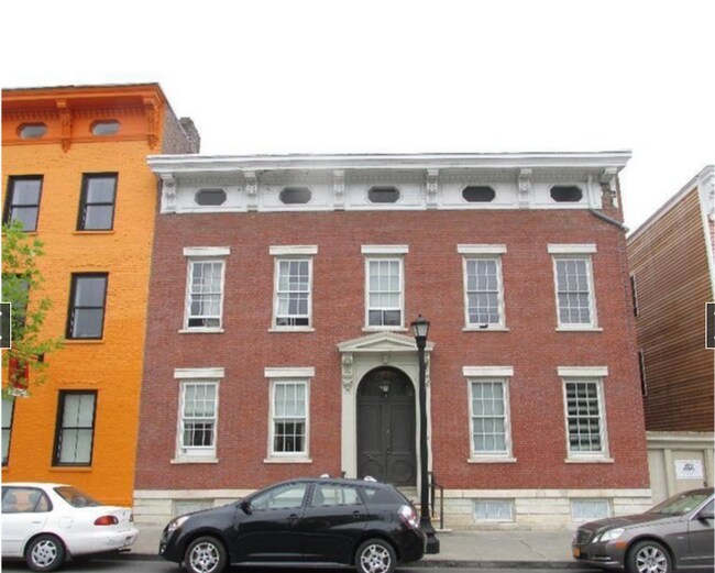
Property Record
245 Warren St, Hudson, NY 12534
NEARBY LISTINGS FOR SALE OR LEASE
Property Detail
245 Warren St
Albany/Schenectady/Troy
Columbia
Hudson, NY
New York
100600-109-043-0002-041-000-0000
0.10 AC
Commercialofficeresidentialmixeduse
Columbia County
6,147 SF
DEMOGRAPHICS near 245 Warren St
1 Mile
3 Mile
5 Mile
2024 Total Population
5,368
13,173
24,078
2029 Population
5,374
13,186
24,176
Pop Growth 2024-2029
+ 0.11%
+ 0.10%
+ 0.41%
Average Age
42
44
45
2024 Total Households
2,497
6,072
10,844
HH Growth 2024-2029
+ 0.20%
+ 0.10%
+ 0.40%
Median Household Inc
$40,846
$56,698
$60,664
Avg Household Size
2.00
2.00
2.10
2024 Avg HH Vehicles
1.00
2.00
2.00
Median Home Value
$304,082
$234,458
$218,167
Median Year Built
1947
1956
1957
Nearby Places
- Restaurants
- Banks
- Shops
- Fitness
- Groceries
PUBLIC TRANSPORTATION
COMMUTER RAIL
DRIVE
WALK
Distance
2 min
8 min
0.4 mi
DRIVE
WALK
Distance
2 min
9 min
0.5 mi
AIRPORT
Albany International
DRIVE
WALK
Distance
Albany International
65 min
43.5 mi
SALE & LEASE HISTORY
LISTING DATE
SALE/LEASE

Apr 20, 2020
For Sale
Nearby Properties
Address
Land Use
TOTAL SIZE
Lot Size
Zoning
Address
Land Use
TOTAL SIZE
Lot Size
Zoning
177,400 SF
6.30 AC
R5
Address
Land Use
TOTAL SIZE
Lot Size
Zoning
0.97 AC
03 - MULTI
Address
Land Use
TOTAL SIZE
Lot Size
Zoning
124,152 SF
44.44 AC
06 - INDUS
Address
Land Use
TOTAL SIZE
Lot Size
Zoning
18,275 SF
163.60 AC
R1
Address
Land Use
TOTAL SIZE
Lot Size
Zoning
126.10 AC
02 - SINGL
Address
Land Use
TOTAL SIZE
Lot Size
Zoning
204,480 SF
20.37 AC
402
Address
Land Use
TOTAL SIZE
Lot Size
Zoning
132,945 SF
21.60 AC
R1
Address
Land Use
TOTAL SIZE
Lot Size
Zoning
72,014 SF
1.30 AC
R5
Address
Land Use
TOTAL SIZE
Lot Size
Zoning
60,741 SF
7.75 AC
06 - INDUS
Address
Land Use
TOTAL SIZE
Lot Size
Zoning
63,446 SF
9.40 AC
402
Address
Land Use
TOTAL SIZE
Lot Size
Zoning
153,801 SF
24.87 AC
0402
Address
Land Use
TOTAL SIZE
Lot Size
Zoning
Address
Land Use
TOTAL SIZE
Lot Size
Zoning
110,000 SF
17.67 AC
402
Address
Land Use
TOTAL SIZE
Lot Size
Zoning
136,833 SF
18.34 AC
402
Address
Land Use
TOTAL SIZE
Lot Size
Zoning
34.82 AC
03 - MULTI
Address
Land Use
TOTAL SIZE
Lot Size
Zoning
41,454 SF
0.76 AC
CC
Address
Land Use
TOTAL SIZE
Lot Size
Zoning
1,226.97 AC
07
Address
Land Use
TOTAL SIZE
Lot Size
Zoning
26,048 SF
5.51 AC
07 - MIXED
Address
Land Use
TOTAL SIZE
Lot Size
Zoning
150,204 SF
31.51 AC
07 - MIXED
Address
Land Use
TOTAL SIZE
Lot Size
Zoning
102,761 SF
10.07 AC
0402
Address
Land Use
TOTAL SIZE
Lot Size
Zoning
74,072 SF
5.30 AC
R1
Address
Land Use
TOTAL SIZE
Lot Size
Zoning
103,366 SF
1.30 AC
R5
Address
Land Use
TOTAL SIZE
Lot Size
Zoning
21,960 SF
11.36 AC
08 - GOVER
Address
Land Use
TOTAL SIZE
Lot Size
Zoning
57,865 SF
6.20 AC
402
Address
Land Use
TOTAL SIZE
Lot Size
Zoning
Address
Land Use
TOTAL SIZE
Lot Size
Zoning
305,070 SF
21.10 AC
I1
Address
Land Use
TOTAL SIZE
Lot Size
Zoning
192,100 SF
19.22 AC
07 - MIXED
Address
Land Use
TOTAL SIZE
Lot Size
Zoning
7,176 SF
2.50 AC
R4
Address
Land Use
TOTAL SIZE
Lot Size
Zoning
107,268 SF
4.43 AC
GC
Address
Land Use
TOTAL SIZE
Lot Size
Zoning
76,750 SF
1.20 AC
GC
The World's #1 Commercial Real Estate Marketplace
Connect with us
© 2025 CoStar Group
The information above has been obtained from sources believed reliable. While we do not doubt its accuracy we have not verified it and make no guarantee, warranty or representation about it. It is your responsibility to independently confirm its accuracy and completeness. Any projections, opinions, assumptions, or estimates used are for example only and do not represent the current or future performance of the property. The value of this transaction to you depends on tax and other factors which should be evaluated by your tax, financial, and legal advisors. You and your advisors should conduct a careful, independent investigation of the property to determine to your satisfaction the suitability of the property for your needs.