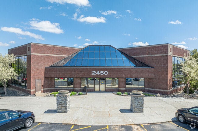
Property Record
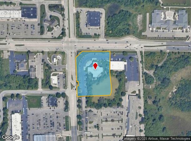
2450 44Th St Se, Grand Rapids, MI 49512
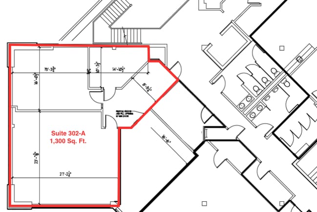
Current Lease Availabilities
NEARBY LISTINGS FOR SALE OR LEASE
Property Detail
2450 44Th St Se
41-18-27-101-019
PART OF NW 1/4 COM AT NW COR OF SEC TH S 2D 10M 00S E ALONG W SEC LINE 50.06 FT TO S LINE OF 44TH ST /100 FT WIDE/ TH S 89D
Commercialnec
Kent
X
Michigan
26081C0438D
2.89 AC
2024
S Grand Rapids/Kentwood
2025
West Michigan
012704
Grand Rapids-Wyoming, MI
34,850 SF
DEMOGRAPHICS near 2450 44Th St Se
1 Mile
3 Mile
5 Mile
2024 Total Population
12,862
80,925
200,496
2029 Population
12,974
81,669
201,846
Pop Growth 2024-2029
+ 0.87%
+ 0.92%
+ 0.67%
Average Age
40
38
37
2024 Total Households
5,631
32,353
74,824
HH Growth 2024-2029
+ 0.99%
+ 0.91%
+ 0.70%
Median Household Inc
$50,848
$61,605
$65,339
Avg Household Size
2.20
2.40
2.60
2024 Avg HH Vehicles
1.00
2.00
2.00
Median Home Value
$226,360
$224,228
$219,274
Median Year Built
1986
1981
1972
Nearby Places
- Restaurants
- Banks
- Shops
- Fitness
- Groceries
Nearby Properties
Address
Land Use
TOTAL SIZE
Lot Size
Zoning
Address
Land Use
TOTAL SIZE
Lot Size
Zoning
563,998 SF
31.75 AC
C3
Address
Land Use
TOTAL SIZE
Lot Size
Zoning
385,631 SF
45.27 AC
R-PUD-1
Address
Land Use
TOTAL SIZE
Lot Size
Zoning
476,572 SF
51.60 AC
R4
Address
Land Use
TOTAL SIZE
Lot Size
Zoning
446,986 SF
72.57 AC
R4
Address
Land Use
TOTAL SIZE
Lot Size
Zoning
521,735 SF
52.16 AC
MON-C
Address
Land Use
TOTAL SIZE
Lot Size
Zoning
341,808 SF
27.73 AC
HC-PUD
Address
Land Use
TOTAL SIZE
Lot Size
Zoning
48.43 AC
PUD-PL UNI
Address
Land Use
TOTAL SIZE
Lot Size
Zoning
649,177 SF
55.67 AC
SD-IT
Address
Land Use
TOTAL SIZE
Lot Size
Zoning
155.84 AC
Address
Land Use
TOTAL SIZE
Lot Size
Zoning
223,931 SF
18 AC
R-PUD-1
Address
Land Use
TOTAL SIZE
Lot Size
Zoning
941,968 SF
38.56 AC
SD-IT
Address
Land Use
TOTAL SIZE
Lot Size
Zoning
216,171 SF
32.06 AC
R4
Address
Land Use
TOTAL SIZE
Lot Size
Zoning
27.25 AC
SD-PRD
Address
Land Use
TOTAL SIZE
Lot Size
Zoning
1,426,319 SF
54.81 AC
SD-IT
Address
Land Use
TOTAL SIZE
Lot Size
Zoning
208.39 AC
I-PUD
Address
Land Use
TOTAL SIZE
Lot Size
Zoning
22.46 AC
MON-MDR
Address
Land Use
TOTAL SIZE
Lot Size
Zoning
292,825 SF
15.01 AC
R-PUD-1
Address
Land Use
TOTAL SIZE
Lot Size
Zoning
685,902 SF
38.89 AC
I1
Address
Land Use
TOTAL SIZE
Lot Size
Zoning
267,336 SF
13.99 AC
R-PUD-1
Address
Land Use
TOTAL SIZE
Lot Size
Zoning
63.52 AC
Address
Land Use
TOTAL SIZE
Lot Size
Zoning
127,141 SF
17.04 AC
C2
Address
Land Use
TOTAL SIZE
Lot Size
Zoning
455,880 SF
24.91 AC
I1
Address
Land Use
TOTAL SIZE
Lot Size
Zoning
15.94 AC
MON-MDR
Address
Land Use
TOTAL SIZE
Lot Size
Zoning
400,646 SF
23.78 AC
I1
Address
Land Use
TOTAL SIZE
Lot Size
Zoning
25.05 AC
R3-MED RES
Address
Land Use
TOTAL SIZE
Lot Size
Zoning
13.71 AC
MCN-LDR
Address
Land Use
TOTAL SIZE
Lot Size
Zoning
330,346 SF
49.71 AC
I1
Address
Land Use
TOTAL SIZE
Lot Size
Zoning
304,200 SF
R1
Address
Land Use
TOTAL SIZE
Lot Size
Zoning
16.91 AC
MON-MDR
Address
Land Use
TOTAL SIZE
Lot Size
Zoning
146,732 SF
21.16 AC
R4
The World's #1 Commercial Real Estate Marketplace
Connect with us
© 2025 CoStar Group
The information above has been obtained from sources believed reliable. While we do not doubt its accuracy we have not verified it and make no guarantee, warranty or representation about it. It is your responsibility to independently confirm its accuracy and completeness. Any projections, opinions, assumptions, or estimates used are for example only and do not represent the current or future performance of the property. The value of this transaction to you depends on tax and other factors which should be evaluated by your tax, financial, and legal advisors. You and your advisors should conduct a careful, independent investigation of the property to determine to your satisfaction the suitability of the property for your needs.