Property Record
2450 Romig Rd, Akron, OH 44320
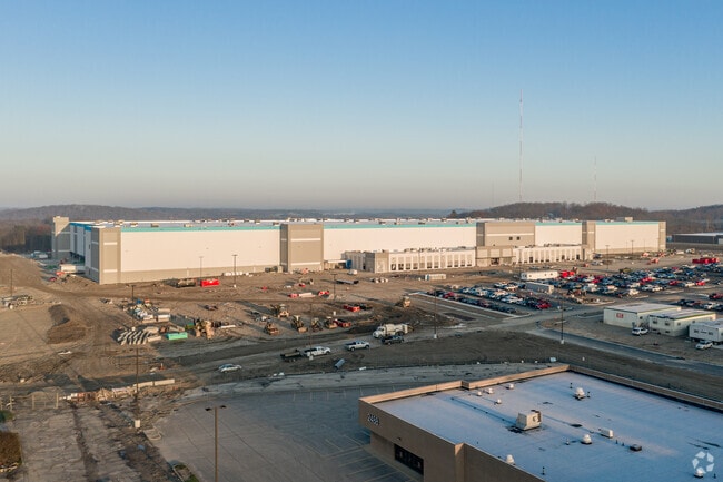

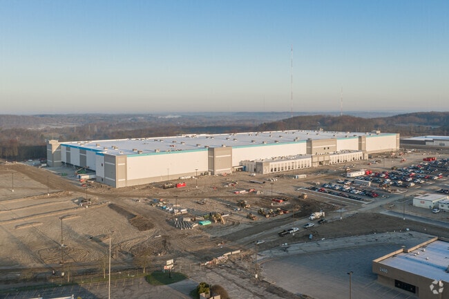
Property Detail
2450 Romig Rd
Akron, OH
TR 1 LOTS 2 & 3 W OF ROMIG RD 92.9482 AC APPEAL BTA TAX YEAR 2022
68-62010
Summit
Warehouse
Ohio
2023
2,3
2025
92.95 AC
508399
Akron
1,397,532 SF
Cleveland
NEARBY LISTINGS FOR SALE OR LEASE
DEMOGRAPHICS near 2450 Romig Rd
1 mile
3 mile
5 mile
2025 Total Population
4,847
60,276
160,215
2030 Population
4,858
60,540
160,810
Pop Growth 2025-2030
+ 0.23%
+ 0.44%
+ 0.37%
Average Age
42
41
41
2025 Total Households
2,217
26,058
69,654
HH Growth 2025-2030
+ 0.32%
+ 0.40%
+ 0.33%
Median Household Inc
$48,853
$45,741
$50,093
Avg Household Size
2.20
2.20
2.20
2025 Avg HH Vehicles
2.00
2.00
2.00
Median Home Value
$85,944
$116,443
$144,862
Median Year Built
1955
1953
1953
Nearby Places
Map Layers
Map Styles
 Street
 Aerial
Layers
 Traffic
 Biking
Places
Listings with unknown addresses are not visible on the map
- Restaurants
- Banks
- Shops
- Fitness
- Groceries
PUBLIC TRANSPORTATION
COMMUTER RAIL
Akron Northside (National Park Scenic Railway - Cuyahoga Valley Scenic Railroad)
Drive
Walk
Distance
Akron Northside (National Park Scenic Railway - Cuyahoga Valley Scenic Railroad)
14 min
6.8 mi
Big Bend (National Park Scenic Railway - Cuyahoga Valley Scenic Railroad)
Drive
Walk
Distance
Big Bend (National Park Scenic Railway - Cuyahoga Valley Scenic Railroad)
20 min
9.3 mi
AIRPORT
Akron-Canton Regional
Drive
Walk
Distance
Akron-Canton Regional
23 min
15.2 mi
Cleveland-Hopkins International
Drive
Walk
Distance
Cleveland-Hopkins International
59 min
39.9 mi
Freight Ports
Port of Toledo
Drive
Walk
Distance
Port of Toledo
163 min
135.2 mi
Nearby Properties
Address
Land Use
TOTAL SIZE
Lot Size
Zoning
Address
Land Use
TOTAL SIZE
Lot Size
Zoning
252,222 SF
12.65 AC
Address
Land Use
TOTAL SIZE
Lot Size
Zoning
Address
Land Use
TOTAL SIZE
Lot Size
Zoning
246,312 SF
17.50 AC
Address
Land Use
TOTAL SIZE
Lot Size
Zoning
132,611 SF
3.56 AC
Address
Land Use
TOTAL SIZE
Lot Size
Zoning
Address
Land Use
TOTAL SIZE
Lot Size
Zoning
166,625 SF
11.37 AC
Address
Land Use
TOTAL SIZE
Lot Size
Zoning
Address
Land Use
TOTAL SIZE
Lot Size
Zoning
184,791 SF
3.25 AC
Address
Land Use
TOTAL SIZE
Lot Size
Zoning
Address
Land Use
TOTAL SIZE
Lot Size
Zoning
57,180 SF
6.67 AC
Address
Land Use
TOTAL SIZE
Lot Size
Zoning
54,398 SF
8.10 AC
Address
Land Use
TOTAL SIZE
Lot Size
Zoning
148.10 AC
Address
Land Use
TOTAL SIZE
Lot Size
Zoning
81,108 SF
3.86 AC
Address
Land Use
TOTAL SIZE
Lot Size
Zoning
99,931 SF
16.82 AC
Address
Land Use
TOTAL SIZE
Lot Size
Zoning
253,690 SF
12.18 AC
Address
Land Use
TOTAL SIZE
Lot Size
Zoning
65,436 SF
34.63 AC
Address
Land Use
TOTAL SIZE
Lot Size
Zoning
130,893 SF
11.70 AC
Address
Land Use
TOTAL SIZE
Lot Size
Zoning
Address
Land Use
TOTAL SIZE
Lot Size
Zoning
59,492 SF
5.51 AC
Address
Land Use
TOTAL SIZE
Lot Size
Zoning
63,918 SF
4.95 AC
Address
Land Use
TOTAL SIZE
Lot Size
Zoning
112,894 SF
12.26 AC
Address
Land Use
TOTAL SIZE
Lot Size
Zoning
61,897 SF
2.75 AC
Address
Land Use
TOTAL SIZE
Lot Size
Zoning
77,444 SF
13.02 AC
Address
Land Use
TOTAL SIZE
Lot Size
Zoning
113,321 SF
13.32 AC
Address
Land Use
TOTAL SIZE
Lot Size
Zoning
53,074 SF
7.29 AC
Address
Land Use
TOTAL SIZE
Lot Size
Zoning
52,270 SF
3.89 AC
Address
Land Use
TOTAL SIZE
Lot Size
Zoning
125,245 SF
6.11 AC
Address
Land Use
TOTAL SIZE
Lot Size
Zoning
20,000 SF
23.71 AC
Address
Land Use
TOTAL SIZE
Lot Size
Zoning
5,520 SF
68.52 AC
The World's #1 Commercial Real Estate Marketplace
Connect with us
© 2026 CoStar Group
The information above has been obtained from sources believed reliable. While we do not doubt its accuracy we have not verified it and make no guarantee, warranty or representation about it. It is your responsibility to independently confirm its accuracy and completeness. Any projections, opinions, assumptions, or estimates used are for example only and do not represent the current or future performance of the property. The value of this transaction to you depends on tax and other factors which should be evaluated by your tax, financial, and legal advisors. You and your advisors should conduct a careful, independent investigation of the property to determine to your satisfaction the suitability of the property for your needs.