Property Record
2450 W Highway 101, Port Angeles, WA 98363

NEARBY LISTINGS FOR SALE OR LEASE
-
-
View all Port Angeles listings for lease on LoopNet.com
Property Detail
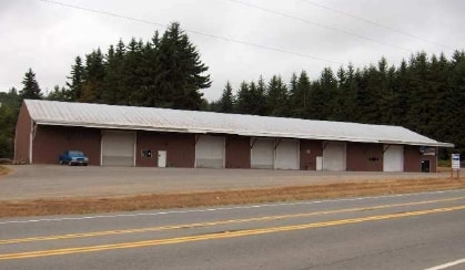
2450 W Highway 101
Port Angeles, WA
Koester
63628
LOT 3 KOESTER SP V4 P22
Warehouse
Clallam
X
Washington
53009C1157F
3
2024
3.32 AC
2025
Bellingham/Northwest
001500
Other Market Areas
9,600 SF
DEMOGRAPHICS near 2450 W Highway 101
1 Mile
3 Mile
5 Mile
2024 Total Population
433
13,998
25,271
2029 Population
455
14,673
26,483
Pop Growth 2024-2029
+ 5.08%
+ 4.82%
+ 4.80%
Average Age
43
42
43
2024 Total Households
175
5,894
11,133
HH Growth 2024-2029
+ 5.14%
+ 4.82%
+ 4.80%
Median Household Inc
$62,946
$62,312
$59,407
Avg Household Size
2.40
2.30
2.20
2024 Avg HH Vehicles
2.00
2.00
2.00
Median Home Value
$303,571
$296,802
$312,302
Median Year Built
1996
1975
1972
Nearby Places
Map Layers
Map Styles
 Street
 Aerial
- Restaurants
- Banks
- Shops
- Fitness
- Groceries
SALE & LEASE HISTORY
LISTING DATE
SALE/LEASE

Sep 25, 2017
For Lease
Dec 07, 2016
For Lease
Nearby Properties
Address
Land Use
TOTAL SIZE
Lot Size
Zoning
Address
Land Use
TOTAL SIZE
Lot Size
Zoning
18.47 AC
RLC
Address
Land Use
TOTAL SIZE
Lot Size
Zoning
58,145 SF
30.33 AC
M
Address
Land Use
TOTAL SIZE
Lot Size
Zoning
65.60 AC
Address
Land Use
TOTAL SIZE
Lot Size
Zoning
33,120 SF
2.50 AC
PCSD
Address
Land Use
TOTAL SIZE
Lot Size
Zoning
47,287 SF
4.73 AC
PCSD
Address
Land Use
TOTAL SIZE
Lot Size
Zoning
36,253 SF
44.94 AC
M
Address
Land Use
TOTAL SIZE
Lot Size
Zoning
3,680 SF
1 AC
M
Address
Land Use
TOTAL SIZE
Lot Size
Zoning
1,196 SF
4.15 AC
RHD
Address
Land Use
TOTAL SIZE
Lot Size
Zoning
728 SF
15.47 AC
Address
Land Use
TOTAL SIZE
Lot Size
Zoning
Address
Land Use
TOTAL SIZE
Lot Size
Zoning
31,168 SF
1.32 AC
Address
Land Use
TOTAL SIZE
Lot Size
Zoning
6,864 SF
3.21 AC
Address
Land Use
TOTAL SIZE
Lot Size
Zoning
9,288 SF
2.62 AC
PRHD
Address
Land Use
TOTAL SIZE
Lot Size
Zoning
16,664 SF
1.86 AC
Address
Land Use
TOTAL SIZE
Lot Size
Zoning
7,800 SF
0.80 AC
OC
Address
Land Use
TOTAL SIZE
Lot Size
Zoning
20,340 SF
18.09 AC
Address
Land Use
TOTAL SIZE
Lot Size
Zoning
2,700 SF
6.34 AC
VLDLD
Address
Land Use
TOTAL SIZE
Lot Size
Zoning
31,100 SF
6.15 AC
M
Address
Land Use
TOTAL SIZE
Lot Size
Zoning
2,298 SF
0.85 AC
PCSD
Address
Land Use
TOTAL SIZE
Lot Size
Zoning
Address
Land Use
TOTAL SIZE
Lot Size
Zoning
9,760 SF
166.53 AC
PIL
Address
Land Use
TOTAL SIZE
Lot Size
Zoning
7,050 SF
2.28 AC
R2
Address
Land Use
TOTAL SIZE
Lot Size
Zoning
6,479 SF
20.33 AC
RCC3
Address
Land Use
TOTAL SIZE
Lot Size
Zoning
1.12 AC
Address
Land Use
TOTAL SIZE
Lot Size
Zoning
5,668 SF
2.86 AC
R2
Address
Land Use
TOTAL SIZE
Lot Size
Zoning
4,400 SF
1 AC
M
Address
Land Use
TOTAL SIZE
Lot Size
Zoning
3,984 SF
1.22 AC
PRHD
Address
Land Use
TOTAL SIZE
Lot Size
Zoning
4,631 SF
7.08 AC
Address
Land Use
TOTAL SIZE
Lot Size
Zoning
3,063 SF
0.32 AC
PCN
Address
Land Use
TOTAL SIZE
Lot Size
Zoning
17,416 SF
10.21 AC
M
The World's #1 Commercial Real Estate Marketplace
Connect with us
© 2026 CoStar Group
The information above has been obtained from sources believed reliable. While we do not doubt its accuracy we have not verified it and make no guarantee, warranty or representation about it. It is your responsibility to independently confirm its accuracy and completeness. Any projections, opinions, assumptions, or estimates used are for example only and do not represent the current or future performance of the property. The value of this transaction to you depends on tax and other factors which should be evaluated by your tax, financial, and legal advisors. You and your advisors should conduct a careful, independent investigation of the property to determine to your satisfaction the suitability of the property for your needs.