Property Record
2450 W Silver Spring Dr, Milwaukee, WI 53209
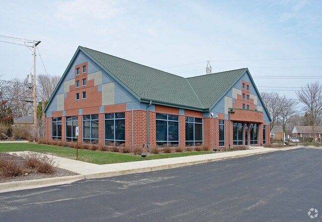

Property Detail
2450 W Silver Spring Dr
Milwaukee-Waukesha, WI
CERTIFIED SURVEY MAP 36767 SW1/4 SEC 30-8-22, PARCEL 1
169-0170-001
Milwaukee
Commercialnec
Wisconsin
B and X Area of moderate flood hazard, usually the area between the limits of the 100-year and 500-year floods.
1
2024
0.41 AC
2025
Milwaukee NW
060200
Milwaukee/Madison
4,350 SF
NEARBY LISTINGS FOR SALE OR LEASE
DEMOGRAPHICS near 2450 W Silver Spring Dr
1 mile
3 mile
5 mile
2025 Total Population
14,786
125,651
346,152
2030 Population
14,846
125,822
346,542
Pop Growth 2025-2030
+ 0.41%
+ 0.14%
+ 0.11%
Average Age
38
37
37
2025 Total Households
6,178
48,960
138,301
HH Growth 2025-2030
+ 0.24%
+ 0.01%
(0.08%)
Median Household Inc
$48,432
$49,428
$54,594
Avg Household Size
2.30
2.50
2.40
2025 Avg HH Vehicles
1.00
1.00
1.00
Median Home Value
$146,129
$179,728
$199,079
Median Year Built
1952
1951
1951
Nearby Places
Map Layers
Map Styles
 Street
 Aerial
Layers
 Traffic
 Biking
Places
Listings with unknown addresses are not visible on the map
- Restaurants
- Banks
- Shops
- Fitness
- Groceries
PUBLIC TRANSPORTATION
COMMUTER RAIL
Drive
Walk
Distance
15 min
7.7 mi
AIRPORT
General Mitchell International
Drive
Walk
Distance
General Mitchell International
26 min
14.3 mi
Freight Ports
Port Milwaukee
Drive
Walk
Distance
Port Milwaukee
18 min
10.1 mi
SALE & LEASE HISTORY
LISTING DATE
SALE/LEASE

Oct 13, 2022
For Sale
Mar 21, 2023
For Sale
Nearby Properties
Address
Land Use
TOTAL SIZE
Lot Size
Zoning
Address
Land Use
TOTAL SIZE
Lot Size
Zoning
5,104 SF
0.11 AC
LB1
Address
Land Use
TOTAL SIZE
Lot Size
Zoning
305,573 SF
3.20 AC
Address
Land Use
TOTAL SIZE
Lot Size
Zoning
66,245 SF
10.21 AC
Address
Land Use
TOTAL SIZE
Lot Size
Zoning
527,776 SF
33.23 AC
Address
Land Use
TOTAL SIZE
Lot Size
Zoning
685,390 SF
26.20 AC
Address
Land Use
TOTAL SIZE
Lot Size
Zoning
152,640 SF
10.50 AC
Address
Land Use
TOTAL SIZE
Lot Size
Zoning
171,170 SF
25.88 AC
Address
Land Use
TOTAL SIZE
Lot Size
Zoning
224,756 SF
12 AC
RESIDENTIA
Address
Land Use
TOTAL SIZE
Lot Size
Zoning
145,218 SF
10.23 AC
Address
Land Use
TOTAL SIZE
Lot Size
Zoning
0.71 AC
RM2
Address
Land Use
TOTAL SIZE
Lot Size
Zoning
213,218 SF
11 AC
Address
Land Use
TOTAL SIZE
Lot Size
Zoning
241,520 SF
6.60 AC
Address
Land Use
TOTAL SIZE
Lot Size
Zoning
294,553 SF
6.19 AC
Address
Land Use
TOTAL SIZE
Lot Size
Zoning
298,666 SF
5.09 AC
PD
Address
Land Use
TOTAL SIZE
Lot Size
Zoning
235,364 SF
7.20 AC
Address
Land Use
TOTAL SIZE
Lot Size
Zoning
90,714 SF
4.18 AC
Address
Land Use
TOTAL SIZE
Lot Size
Zoning
195,507 SF
1.92 AC
Address
Land Use
TOTAL SIZE
Lot Size
Zoning
2.15 AC
RT4
Address
Land Use
TOTAL SIZE
Lot Size
Zoning
66.42 AC
IL1
Address
Land Use
TOTAL SIZE
Lot Size
Zoning
72,676 SF
6.22 AC
Address
Land Use
TOTAL SIZE
Lot Size
Zoning
169,550 SF
12.04 AC
RB2
Address
Land Use
TOTAL SIZE
Lot Size
Zoning
229,111 SF
Address
Land Use
TOTAL SIZE
Lot Size
Zoning
137,100 SF
6.69 AC
IL2
Address
Land Use
TOTAL SIZE
Lot Size
Zoning
74,526 SF
5.42 AC
Address
Land Use
TOTAL SIZE
Lot Size
Zoning
48,540 SF
4.28 AC
Address
Land Use
TOTAL SIZE
Lot Size
Zoning
127,584 SF
3.28 AC
Address
Land Use
TOTAL SIZE
Lot Size
Zoning
18.54 AC
RS6
Address
Land Use
TOTAL SIZE
Lot Size
Zoning
100,126 SF
4 AC
Address
Land Use
TOTAL SIZE
Lot Size
Zoning
61,910 SF
7.84 AC
Address
Land Use
TOTAL SIZE
Lot Size
Zoning
36,755 SF
6.44 AC
The World's #1 Commercial Real Estate Marketplace
Connect with us
© 2026 CoStar Group
The information above has been obtained from sources believed reliable. While we do not doubt its accuracy we have not verified it and make no guarantee, warranty or representation about it. It is your responsibility to independently confirm its accuracy and completeness. Any projections, opinions, assumptions, or estimates used are for example only and do not represent the current or future performance of the property. The value of this transaction to you depends on tax and other factors which should be evaluated by your tax, financial, and legal advisors. You and your advisors should conduct a careful, independent investigation of the property to determine to your satisfaction the suitability of the property for your needs.