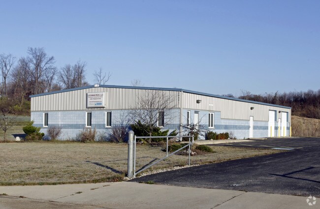
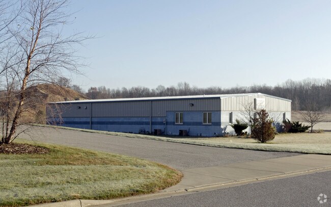
Property Record
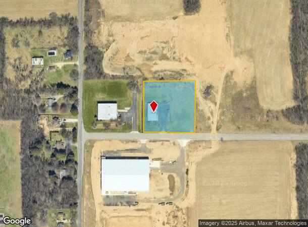
24501 Research Dr, South Bend, IN 46628
NEARBY LISTINGS FOR SALE OR LEASE
-
-
View all South Bend listings for sale on LoopNet.com
Property Detail
24501 Research Dr
South Bend-Mishawaka, IN-MI
Pine Edison Park Ltd Phase One Minor Sub
71-03-31-300-002.000-008
LOT 2A PINE EDISON PARK LTD PHASE ONE MINOR SUB 1ST REPLAT 04-05 NEW REPLAT TR 1363 4-4-03 00-01 SET UP NEW SUB PER TRANS 2527 5-7-99
Lightindustrial
St Joseph
X
Indiana
18141C0178D
2a,d
2023
2.07 AC
2024
Outlying St Joseph County
011100
South Bend/Mishawaka
6,200 SF
DEMOGRAPHICS near 24501 Research Dr
1 Mile
3 Mile
5 Mile
2024 Total Population
550
17,260
63,472
2029 Population
541
17,064
63,561
Pop Growth 2024-2029
(1.64%)
(1.14%)
+ 0.14%
Average Age
43
40
37
2024 Total Households
230
6,650
23,636
HH Growth 2024-2029
(1.74%)
(1.20%)
(0.04%)
Median Household Inc
$59,124
$51,063
$46,557
Avg Household Size
2.40
2.50
2.50
2024 Avg HH Vehicles
2.00
2.00
2.00
Median Home Value
$157,646
$127,520
$118,634
Median Year Built
1959
1958
1957
Nearby Places
Map Layers
Map Styles
 Street
 Aerial
- Restaurants
- Banks
- Shops
- Fitness
- Groceries
PUBLIC TRANSPORTATION
COMMUTER RAIL
South Bend Airport Station (South Shore Line - Northern Indiana Commuter Transportation District (South Shore Line))
DRIVE
WALK
Distance
South Bend Airport Station (South Shore Line - Northern Indiana Commuter Transportation District (South Shore Line))
8 min
2.9 mi
DRIVE
WALK
Distance
11 min
4.7 mi
AIRPORT
South Bend International
DRIVE
WALK
Distance
South Bend International
15 min
3.8 mi
Nearby Properties
Address
Land Use
TOTAL SIZE
Lot Size
Zoning
Address
Land Use
TOTAL SIZE
Lot Size
Zoning
252,327 SF
131 SF
Address
Land Use
TOTAL SIZE
Lot Size
Zoning
633,966 SF
87 SF
Address
Land Use
TOTAL SIZE
Lot Size
Zoning
213,400 SF
44 SF
Address
Land Use
TOTAL SIZE
Lot Size
Zoning
343,964 SF
131 SF
Address
Land Use
TOTAL SIZE
Lot Size
Zoning
225,000 SF
19.59 AC
Address
Land Use
TOTAL SIZE
Lot Size
Zoning
111,803 SF
7.45 AC
Address
Land Use
TOTAL SIZE
Lot Size
Zoning
79,451 SF
87 SF
Address
Land Use
TOTAL SIZE
Lot Size
Zoning
4,428 SF
0.02 AC
Address
Land Use
TOTAL SIZE
Lot Size
Zoning
397,100 SF
45.61 AC
Address
Land Use
TOTAL SIZE
Lot Size
Zoning
92,456 SF
44 SF
Address
Land Use
TOTAL SIZE
Lot Size
Zoning
84,398 SF
44 SF
Address
Land Use
TOTAL SIZE
Lot Size
Zoning
85,928 SF
7.83 AC
Address
Land Use
TOTAL SIZE
Lot Size
Zoning
499,104 SF
87 SF
Address
Land Use
TOTAL SIZE
Lot Size
Zoning
797,259 SF
45.69 AC
Address
Land Use
TOTAL SIZE
Lot Size
Zoning
58,827 SF
131 SF
Address
Land Use
TOTAL SIZE
Lot Size
Zoning
143,805 SF
8.44 AC
Address
Land Use
TOTAL SIZE
Lot Size
Zoning
152,807 SF
87 SF
Address
Land Use
TOTAL SIZE
Lot Size
Zoning
81,900 SF
2.69 AC
Address
Land Use
TOTAL SIZE
Lot Size
Zoning
45,191 SF
44 SF
Address
Land Use
TOTAL SIZE
Lot Size
Zoning
34,056 SF
3.54 AC
Address
Land Use
TOTAL SIZE
Lot Size
Zoning
121,264 SF
11.21 AC
Address
Land Use
TOTAL SIZE
Lot Size
Zoning
150,280 SF
21 AC
Address
Land Use
TOTAL SIZE
Lot Size
Zoning
46,840 SF
44 SF
Address
Land Use
TOTAL SIZE
Lot Size
Zoning
92,478 SF
5.10 AC
Address
Land Use
TOTAL SIZE
Lot Size
Zoning
95,436 SF
44 SF
Address
Land Use
TOTAL SIZE
Lot Size
Zoning
93,477 SF
15.53 AC
Address
Land Use
TOTAL SIZE
Lot Size
Zoning
170,572 SF
44 SF
Address
Land Use
TOTAL SIZE
Lot Size
Zoning
149,184 SF
21.84 AC
Address
Land Use
TOTAL SIZE
Lot Size
Zoning
129,696 SF
7.62 AC
Address
Land Use
TOTAL SIZE
Lot Size
Zoning
49,680 SF
44 SF
The World's #1 Commercial Real Estate Marketplace
Connect with us
© 2025 CoStar Group
The information above has been obtained from sources believed reliable. While we do not doubt its accuracy we have not verified it and make no guarantee, warranty or representation about it. It is your responsibility to independently confirm its accuracy and completeness. Any projections, opinions, assumptions, or estimates used are for example only and do not represent the current or future performance of the property. The value of this transaction to you depends on tax and other factors which should be evaluated by your tax, financial, and legal advisors. You and your advisors should conduct a careful, independent investigation of the property to determine to your satisfaction the suitability of the property for your needs.