Property Record
2455 Paces Ferry Rd, Smyrna, GA 2455
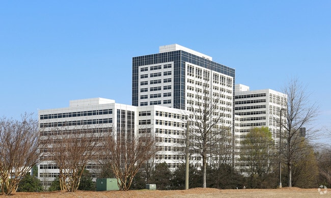

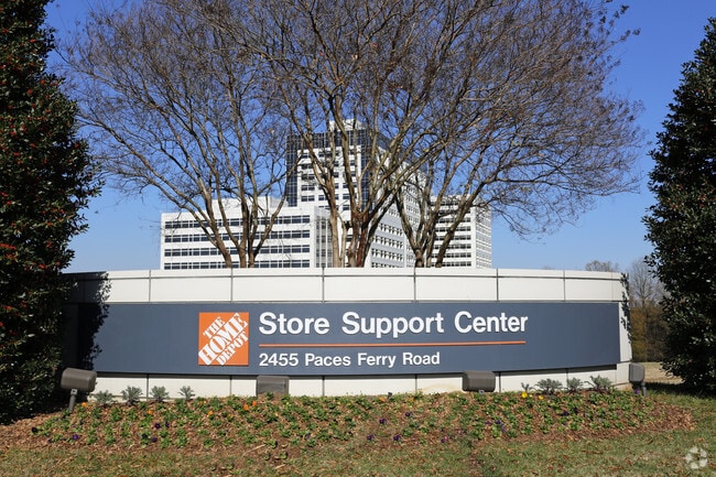
Property Detail
2455 Paces Ferry Rd
17-0815-0-040-0
COBB
Officebuilding
Georgia
OHR
814
B and X Area of moderate flood hazard, usually the area between the limits of the 100-year and 500-year floods.
32.70 AC
2025
Cumberland/Galleria
2025
Atlanta
368101
Atlanta-Sandy Springs-Roswell, GA
3,929,999 SF
NEARBY LISTINGS FOR SALE OR LEASE
DEMOGRAPHICS near 2455 Paces Ferry Rd
1 mile
3 mile
5 mile
2025 Total Population
16,877
95,203
216,855
2030 Population
17,439
98,483
223,728
Pop Growth 2025-2030
+ 3.33%
+ 3.45%
+ 3.17%
Average Age
38
38
38
2025 Total Households
8,800
47,737
97,852
HH Growth 2025-2030
+ 3.50%
+ 3.48%
+ 3.24%
Median Household Inc
$93,611
$100,443
$99,110
Avg Household Size
1.90
2.00
2.20
2025 Avg HH Vehicles
2.00
2.00
2.00
Median Home Value
$625,235
$506,807
$499,571
Median Year Built
1993
1992
1988
Nearby Places
Map Layers
Map Styles
 Street
 Aerial
Layers
 Traffic
 Biking
Places
Listings with unknown addresses are not visible on the map
- Restaurants
- Banks
- Shops
- Fitness
- Groceries
PUBLIC TRANSPORTATION
COMMUTER RAIL
Atlanta (Crescent - Amtrak)
Drive
Walk
Distance
Atlanta (Crescent - Amtrak)
17 min
9.6 mi
AIRPORT
Hartsfield - Jackson Atlanta International
Drive
Walk
Distance
Hartsfield - Jackson Atlanta International
33 min
22.6 mi
Freight Ports
Georgia Ports - Savannah
Drive
Walk
Distance
Georgia Ports - Savannah
295 min
262.0 mi
Nearby Properties
Address
Land Use
TOTAL SIZE
Lot Size
Zoning
Address
Land Use
TOTAL SIZE
Lot Size
Zoning
41,500 SF
15.61 AC
RRC
Address
Land Use
TOTAL SIZE
Lot Size
Zoning
649,754 SF
20.73 AC
PSC/CRC
Address
Land Use
TOTAL SIZE
Lot Size
Zoning
1,116,209 SF
5.05 AC
OHR
Address
Land Use
TOTAL SIZE
Lot Size
Zoning
417,453 SF
21.94 AC
RMR
Address
Land Use
TOTAL SIZE
Lot Size
Zoning
610,147 SF
45.74 AC
RRC
Address
Land Use
TOTAL SIZE
Lot Size
Zoning
173,430 SF
13.83 AC
PVC
Address
Land Use
TOTAL SIZE
Lot Size
Zoning
789,925 SF
3.77 AC
GC
Address
Land Use
TOTAL SIZE
Lot Size
Zoning
553,125 SF
42.07 AC
PRD MF
Address
Land Use
TOTAL SIZE
Lot Size
Zoning
394,294 SF
21.56 AC
OHR
Address
Land Use
TOTAL SIZE
Lot Size
Zoning
5.36 AC
RRC
Address
Land Use
TOTAL SIZE
Lot Size
Zoning
968,384 SF
4.93 AC
GC
Address
Land Use
TOTAL SIZE
Lot Size
Zoning
237,743 SF
10.32 AC
RRC
Address
Land Use
TOTAL SIZE
Lot Size
Zoning
468,079 SF
31.79 AC
RMR
Address
Land Use
TOTAL SIZE
Lot Size
Zoning
583,570 SF
4.56 AC
PVC/OI
Address
Land Use
TOTAL SIZE
Lot Size
Zoning
403,545 SF
6.33 AC
RRC
Address
Land Use
TOTAL SIZE
Lot Size
Zoning
883,054 SF
3 AC
GC
Address
Land Use
TOTAL SIZE
Lot Size
Zoning
16,408 SF
8.97 AC
PVC
Address
Land Use
TOTAL SIZE
Lot Size
Zoning
480,544 SF
2.36 AC
RRC
Address
Land Use
TOTAL SIZE
Lot Size
Zoning
483,147 SF
29.70 AC
RM-16
Address
Land Use
TOTAL SIZE
Lot Size
Zoning
482,016 SF
50.92 AC
RM-8
Address
Land Use
TOTAL SIZE
Lot Size
Zoning
3.51 AC
RRC
Address
Land Use
TOTAL SIZE
Lot Size
Zoning
914,424 SF
56.61 AC
OI
Address
Land Use
TOTAL SIZE
Lot Size
Zoning
550,043 SF
26.83 AC
OI
Address
Land Use
TOTAL SIZE
Lot Size
Zoning
2.81 AC
RRC
Address
Land Use
TOTAL SIZE
Lot Size
Zoning
389,428 SF
22.50 AC
RM12
Address
Land Use
TOTAL SIZE
Lot Size
Zoning
550,144 SF
4.70 AC
RRC
Address
Land Use
TOTAL SIZE
Lot Size
Zoning
560,836 SF
60.28 AC
RM-8
Address
Land Use
TOTAL SIZE
Lot Size
Zoning
379,000 SF
29.86 AC
RM-12
Address
Land Use
TOTAL SIZE
Lot Size
Zoning
787,804 SF
5.64 AC
GC
The World's #1 Commercial Real Estate Marketplace
Connect with us
© 2026 CoStar Group
The information above has been obtained from sources believed reliable. While we do not doubt its accuracy we have not verified it and make no guarantee, warranty or representation about it. It is your responsibility to independently confirm its accuracy and completeness. Any projections, opinions, assumptions, or estimates used are for example only and do not represent the current or future performance of the property. The value of this transaction to you depends on tax and other factors which should be evaluated by your tax, financial, and legal advisors. You and your advisors should conduct a careful, independent investigation of the property to determine to your satisfaction the suitability of the property for your needs.