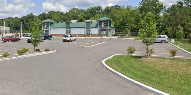
Property Record
2455 W Cleveland Rd, South Bend, IN 46628
NEARBY LISTINGS FOR SALE OR LEASE
Property Detail
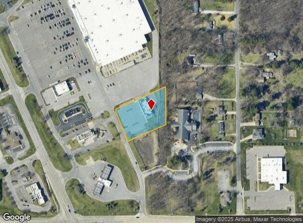
2455 W Cleveland Rd
South Bend-Mishawaka, IN-MI
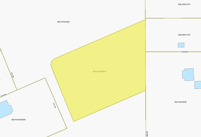
Meijer Portage Rd 4Th Minor Sub
71-03-22-378-005.000-009
LOT 2 MEIJER PORTAGE RD 4TH MINOR SUB 18/19 NP #34 1/04/2018
Restaurantdrivein
St Joseph
X
Indiana
18141C0181D
2
2023
1.37 AC
2024
Greater South Bend
011002
South Bend/Mishawaka
4,246 SF
DEMOGRAPHICS near 2455 W Cleveland Rd
1 Mile
3 Mile
5 Mile
2024 Total Population
4,757
38,923
118,509
2029 Population
4,689
38,980
118,788
Pop Growth 2024-2029
(1.43%)
+ 0.15%
+ 0.24%
Average Age
40
38
37
2024 Total Households
2,263
15,247
44,520
HH Growth 2024-2029
(1.46%)
(0.03%)
+ 0.23%
Median Household Inc
$43,310
$55,119
$54,408
Avg Household Size
2.10
2.40
2.40
2024 Avg HH Vehicles
1.00
2.00
2.00
Median Home Value
$153,604
$142,790
$150,050
Median Year Built
1978
1961
1962
Nearby Places
Map Layers
Map Styles
 Street
 Aerial
- Restaurants
- Banks
- Shops
- Fitness
- Groceries
PUBLIC TRANSPORTATION
COMMUTER RAIL
South Bend Airport Station (South Shore Line - Northern Indiana Commuter Transportation District (South Shore Line))
DRIVE
WALK
Distance
South Bend Airport Station (South Shore Line - Northern Indiana Commuter Transportation District (South Shore Line))
10 min
3.3 mi
DRIVE
WALK
Distance
10 min
4.1 mi
AIRPORT
South Bend International
DRIVE
WALK
Distance
South Bend International
19 min
6.3 mi
Nearby Properties
Address
Land Use
TOTAL SIZE
Lot Size
Zoning
Address
Land Use
TOTAL SIZE
Lot Size
Zoning
3,879,729 SF
436.76 AC
Address
Land Use
TOTAL SIZE
Lot Size
Zoning
538,338 SF
0.01 AC
Address
Land Use
TOTAL SIZE
Lot Size
Zoning
160,546 SF
Address
Land Use
TOTAL SIZE
Lot Size
Zoning
151,377 SF
0.01 AC
Address
Land Use
TOTAL SIZE
Lot Size
Zoning
25,756 SF
337.40 AC
Address
Land Use
TOTAL SIZE
Lot Size
Zoning
356,520 SF
28.07 AC
Address
Land Use
TOTAL SIZE
Lot Size
Zoning
174,997 SF
0.70 AC
Address
Land Use
TOTAL SIZE
Lot Size
Zoning
128,298 SF
0.84 AC
Address
Land Use
TOTAL SIZE
Lot Size
Zoning
73,254 SF
96.72 AC
Address
Land Use
TOTAL SIZE
Lot Size
Zoning
747,842 SF
30.05 AC
Address
Land Use
TOTAL SIZE
Lot Size
Zoning
142,065 SF
44 SF
Address
Land Use
TOTAL SIZE
Lot Size
Zoning
232,200 SF
87 SF
Address
Land Use
TOTAL SIZE
Lot Size
Zoning
159,834 SF
44 SF
Address
Land Use
TOTAL SIZE
Lot Size
Zoning
157,702 SF
44 SF
Address
Land Use
TOTAL SIZE
Lot Size
Zoning
114,844 SF
4.17 AC
Address
Land Use
TOTAL SIZE
Lot Size
Zoning
210,420 SF
131 SF
Address
Land Use
TOTAL SIZE
Lot Size
Zoning
212,497 SF
131 SF
Address
Land Use
TOTAL SIZE
Lot Size
Zoning
210,420 SF
131 SF
Address
Land Use
TOTAL SIZE
Lot Size
Zoning
111,803 SF
7.45 AC
Address
Land Use
TOTAL SIZE
Lot Size
Zoning
63,780 SF
44 SF
Address
Land Use
TOTAL SIZE
Lot Size
Zoning
178,316 SF
44 SF
Address
Land Use
TOTAL SIZE
Lot Size
Zoning
72,418 SF
131 SF
Address
Land Use
TOTAL SIZE
Lot Size
Zoning
214,657 SF
131 SF
Address
Land Use
TOTAL SIZE
Lot Size
Zoning
79,451 SF
87 SF
Address
Land Use
TOTAL SIZE
Lot Size
Zoning
4,428 SF
0.02 AC
Address
Land Use
TOTAL SIZE
Lot Size
Zoning
203,750 SF
22.36 AC
Address
Land Use
TOTAL SIZE
Lot Size
Zoning
63,374 SF
1.99 AC
Address
Land Use
TOTAL SIZE
Lot Size
Zoning
255,684 SF
23.71 AC
Address
Land Use
TOTAL SIZE
Lot Size
Zoning
181,494 SF
1.19 AC
Address
Land Use
TOTAL SIZE
Lot Size
Zoning
397,100 SF
45.61 AC
The World's #1 Commercial Real Estate Marketplace
Connect with us
© 2025 CoStar Group
The information above has been obtained from sources believed reliable. While we do not doubt its accuracy we have not verified it and make no guarantee, warranty or representation about it. It is your responsibility to independently confirm its accuracy and completeness. Any projections, opinions, assumptions, or estimates used are for example only and do not represent the current or future performance of the property. The value of this transaction to you depends on tax and other factors which should be evaluated by your tax, financial, and legal advisors. You and your advisors should conduct a careful, independent investigation of the property to determine to your satisfaction the suitability of the property for your needs.