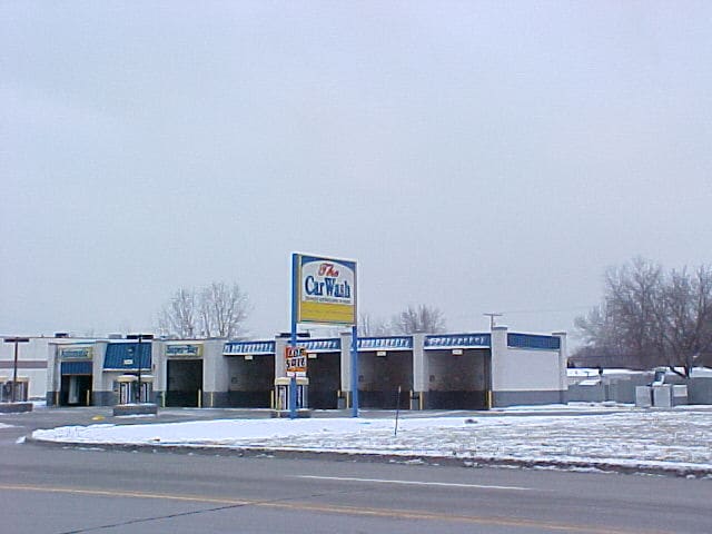
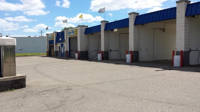
Property Record
260 N River Rd, Mount Clemens, MI 48043

NEARBY LISTINGS FOR SALE OR LEASE
Property Detail
260 N River Rd
Detroit-Warren-Dearborn, MI
Tanadon Condo
05-11-13-254-001
TANADON CONDO PLAN MACOMB COUNTY CONDO PLAN # 744UNIT # 1.
Commercialnec
Macomb
X
Michigan
26099C0351J
0.69 AC
2025
Macomb East
2025
Detroit
245000
DEMOGRAPHICS near 260 N River Rd
1 Mile
3 Mile
5 Mile
2024 Total Population
8,583
67,285
173,848
2029 Population
8,610
67,144
172,507
Pop Growth 2024-2029
+ 0.31%
(0.21%)
(0.77%)
Average Age
40
41
42
2024 Total Households
3,910
30,270
73,686
HH Growth 2024-2029
+ 0.51%
(0.17%)
(0.75%)
Median Household Inc
$39,623
$59,757
$70,254
Avg Household Size
2.10
2.10
2.30
2024 Avg HH Vehicles
1.00
2.00
2.00
Median Home Value
$176,406
$188,279
$217,088
Median Year Built
1970
1974
1979
Nearby Places
Map Layers
Map Styles
 Street
 Aerial
- Restaurants
- Banks
- Shops
- Fitness
- Groceries
PUBLIC TRANSPORTATION
AIRPORT
Windsor International
DRIVE
WALK
Distance
Windsor International
56 min
34.4 mi
Detroit Metro Wayne County
DRIVE
WALK
Distance
Detroit Metro Wayne County
59 min
43.9 mi
SALE & LEASE HISTORY
LISTING DATE
SALE/LEASE

Sep 23, 2016
For Sale
May 09, 2018
For Sale
Feb 18, 2019
For Sale
Nearby Properties
Address
Land Use
TOTAL SIZE
Lot Size
Zoning
Address
Land Use
TOTAL SIZE
Lot Size
Zoning
404,160 SF
22.52 AC
I-1
Address
Land Use
TOTAL SIZE
Lot Size
Zoning
44.65 AC
RML
Address
Land Use
TOTAL SIZE
Lot Size
Zoning
74,382 SF
3.99 AC
OS-1
Address
Land Use
TOTAL SIZE
Lot Size
Zoning
22.14 AC
RM-2
Address
Land Use
TOTAL SIZE
Lot Size
Zoning
29.33 AC
RML
Address
Land Use
TOTAL SIZE
Lot Size
Zoning
20.27 AC
RML
Address
Land Use
TOTAL SIZE
Lot Size
Zoning
25.14 AC
RML
Address
Land Use
TOTAL SIZE
Lot Size
Zoning
252,226 SF
52.79 AC
Address
Land Use
TOTAL SIZE
Lot Size
Zoning
16.06 AC
R-1-C
Address
Land Use
TOTAL SIZE
Lot Size
Zoning
26.92 AC
RML
Address
Land Use
TOTAL SIZE
Lot Size
Zoning
30,607 SF
17.85 AC
RM-1
Address
Land Use
TOTAL SIZE
Lot Size
Zoning
670,448 SF
37.23 AC
L-2
Address
Land Use
TOTAL SIZE
Lot Size
Zoning
196,459 SF
19.18 AC
I-1
Address
Land Use
TOTAL SIZE
Lot Size
Zoning
229,878 SF
19.93 AC
C4 MULT
Address
Land Use
TOTAL SIZE
Lot Size
Zoning
57,316 SF
26.07 AC
RML
Address
Land Use
TOTAL SIZE
Lot Size
Zoning
42,385 SF
25.55 AC
B-2
Address
Land Use
TOTAL SIZE
Lot Size
Zoning
72,572 SF
10 AC
B-3
Address
Land Use
TOTAL SIZE
Lot Size
Zoning
6.10 AC
RM-1
Address
Land Use
TOTAL SIZE
Lot Size
Zoning
134,327 SF
10.02 AC
I-1
Address
Land Use
TOTAL SIZE
Lot Size
Zoning
17.44 AC
RML
Address
Land Use
TOTAL SIZE
Lot Size
Zoning
214,201 SF
24.10 AC
B-3
Address
Land Use
TOTAL SIZE
Lot Size
Zoning
87.32 AC
MH
Address
Land Use
TOTAL SIZE
Lot Size
Zoning
15.05 AC
RM-2
Address
Land Use
TOTAL SIZE
Lot Size
Zoning
17.85 AC
RML
Address
Land Use
TOTAL SIZE
Lot Size
Zoning
45,864 SF
4.60 AC
C2
Address
Land Use
TOTAL SIZE
Lot Size
Zoning
11.87 AC
RM-2
Address
Land Use
TOTAL SIZE
Lot Size
Zoning
120,360 SF
10.70 AC
GC
Address
Land Use
TOTAL SIZE
Lot Size
Zoning
149,652 SF
8.04 AC
SP-1
Address
Land Use
TOTAL SIZE
Lot Size
Zoning
88.65 AC
MH
Address
Land Use
TOTAL SIZE
Lot Size
Zoning
10.43 AC
RML
The World's #1 Commercial Real Estate Marketplace
Connect with us
© 2025 CoStar Group
The information above has been obtained from sources believed reliable. While we do not doubt its accuracy we have not verified it and make no guarantee, warranty or representation about it. It is your responsibility to independently confirm its accuracy and completeness. Any projections, opinions, assumptions, or estimates used are for example only and do not represent the current or future performance of the property. The value of this transaction to you depends on tax and other factors which should be evaluated by your tax, financial, and legal advisors. You and your advisors should conduct a careful, independent investigation of the property to determine to your satisfaction the suitability of the property for your needs.