Property Record
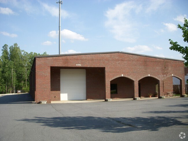
2456 Main St Nw, Duluth, GA 30097


Property Detail
2456 Main St Nw
7-204-004
CHATTAHOOCHEE DR
Warehouse
Gwinnett
M1
Georgia
B and X Area of moderate flood hazard, usually the area between the limits of the 100-year and 500-year floods.
0.91 AC
2025
Duluth/Suwanee/Buford
2025
Atlanta
050235
Atlanta-Sandy Springs-Roswell, GA
10,505 SF
NEARBY LISTINGS FOR SALE OR LEASE
DEMOGRAPHICS near 2456 Main St Nw
1 mile
3 mile
5 mile
2024 Total Population
9,801
71,245
202,086
2029 Population
10,280
74,554
211,091
Pop Growth 2024-2029
+ 4.89%
+ 4.64%
+ 4.46%
Average Age
40
40
39
2024 Total Households
3,421
26,015
72,960
HH Growth 2024-2029
+ 5.09%
+ 4.72%
+ 4.51%
Median Household Inc
$116,893
$104,783
$97,563
Avg Household Size
2.80
2.70
2.70
2024 Avg HH Vehicles
2.00
2.00
2.00
Median Home Value
$463,683
$470,915
$493,336
Median Year Built
1997
1997
1996
Nearby Places
Map Layers
Map Styles
 Street
 Aerial
Transit
 Traffic
 Biking
Places
Listings with unknown addresses are not visible on the map
- Restaurants
- Banks
- Shops
- Fitness
- Groceries
Nearby Properties
Address
Land Use
TOTAL SIZE
Lot Size
Zoning
Address
Land Use
TOTAL SIZE
Lot Size
Zoning
1,457,980 SF
98.78 AC
MUR
Address
Land Use
TOTAL SIZE
Lot Size
Zoning
794,057 SF
78.64 AC
PUD
Address
Land Use
TOTAL SIZE
Lot Size
Zoning
482,658 SF
17.05 AC
MUR
Address
Land Use
TOTAL SIZE
Lot Size
Zoning
509,302 SF
55.13 AC
RM8
Address
Land Use
TOTAL SIZE
Lot Size
Zoning
404,176 SF
32.67 AC
M2
Address
Land Use
TOTAL SIZE
Lot Size
Zoning
393,913 SF
25.93 AC
RM13
Address
Land Use
TOTAL SIZE
Lot Size
Zoning
523,344 SF
40.47 AC
RM
Address
Land Use
TOTAL SIZE
Lot Size
Zoning
280,454 SF
19.97 AC
MUR
Address
Land Use
TOTAL SIZE
Lot Size
Zoning
359,241 SF
21.02 AC
PMUD
Address
Land Use
TOTAL SIZE
Lot Size
Zoning
471,807 SF
69.50 AC
R100
Address
Land Use
TOTAL SIZE
Lot Size
Zoning
423,004 SF
47.93 AC
RM
Address
Land Use
TOTAL SIZE
Lot Size
Zoning
285,038 SF
1.93 AC
MUR
Address
Land Use
TOTAL SIZE
Lot Size
Zoning
620,975 SF
8.10 AC
PUD
Address
Land Use
TOTAL SIZE
Lot Size
Zoning
334,841 SF
28.14 AC
RM13
Address
Land Use
TOTAL SIZE
Lot Size
Zoning
372,904 SF
11.64 AC
PUD
Address
Land Use
TOTAL SIZE
Lot Size
Zoning
609,495 SF
6.28 AC
PUD
Address
Land Use
TOTAL SIZE
Lot Size
Zoning
253,169 SF
8.74 AC
RM24
Address
Land Use
TOTAL SIZE
Lot Size
Zoning
377,960 SF
29.70 AC
RM13
Address
Land Use
TOTAL SIZE
Lot Size
Zoning
365,351 SF
30.70 AC
OI
Address
Land Use
TOTAL SIZE
Lot Size
Zoning
234,420 SF
10.35 AC
PMUD
Address
Land Use
TOTAL SIZE
Lot Size
Zoning
248,400 SF
13.92 AC
MUO
Address
Land Use
TOTAL SIZE
Lot Size
Zoning
418,495 SF
22.06 AC
PUD
Address
Land Use
TOTAL SIZE
Lot Size
Zoning
287,824 SF
31.59 AC
RM
Address
Land Use
TOTAL SIZE
Lot Size
Zoning
217,080 SF
49.32 AC
M1
Address
Land Use
TOTAL SIZE
Lot Size
Zoning
263,285 SF
22.50 AC
RM
Address
Land Use
TOTAL SIZE
Lot Size
Zoning
252,043 SF
22.03 AC
RM
Address
Land Use
TOTAL SIZE
Lot Size
Zoning
256,640 SF
28.59 AC
RM
Address
Land Use
TOTAL SIZE
Lot Size
Zoning
326,904 SF
46.73 AC
OI
Address
Land Use
TOTAL SIZE
Lot Size
Zoning
304,001 SF
32 AC
PUD
Address
Land Use
TOTAL SIZE
Lot Size
Zoning
235,586 SF
16.21 AC
PUD
The World's #1 Commercial Real Estate Marketplace
Connect with us
© 2026 CoStar Group
The information above has been obtained from sources believed reliable. While we do not doubt its accuracy we have not verified it and make no guarantee, warranty or representation about it. It is your responsibility to independently confirm its accuracy and completeness. Any projections, opinions, assumptions, or estimates used are for example only and do not represent the current or future performance of the property. The value of this transaction to you depends on tax and other factors which should be evaluated by your tax, financial, and legal advisors. You and your advisors should conduct a careful, independent investigation of the property to determine to your satisfaction the suitability of the property for your needs.