Property Record
2457 Us Route 9W, Ravena, NY 12143
NEARBY LISTINGS FOR SALE OR LEASE
Property Detail
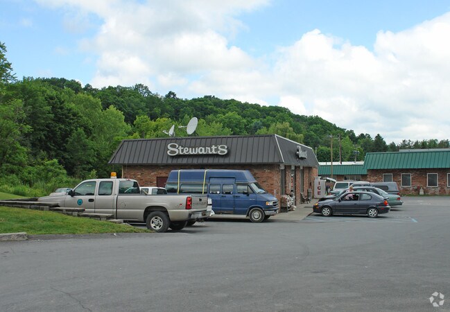
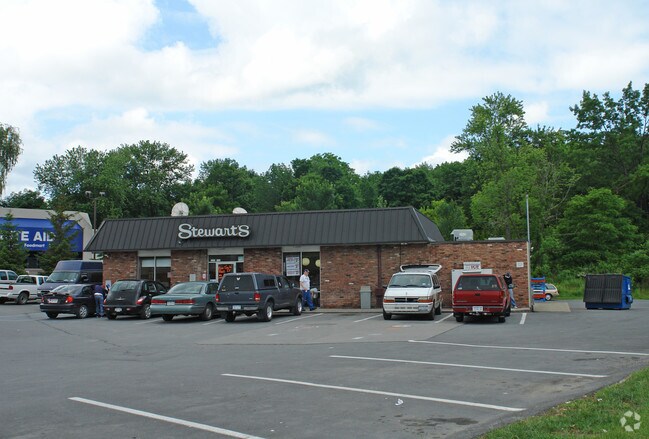
2457 Us Route 9W
012401-168-009-0001-018-020-0000
MINI-MART/LAND (STEWARTS)
Servicestationmarket
Albany
X
New York
36001C0429D
18.020
2025
0.45 AC
2024
W Outer Albany County
014402
Albany/Schenectady/Troy
2,239 SF
Albany-Schenectady-Troy, NY
DEMOGRAPHICS near 2457 Us Route 9W
1 Mile
3 Mile
5 Mile
2024 Total Population
3,710
6,033
10,535
2029 Population
3,687
5,973
10,423
Pop Growth 2024-2029
(0.62%)
(0.99%)
(1.06%)
Average Age
40
42
42
2024 Total Households
1,582
2,567
4,466
HH Growth 2024-2029
(0.57%)
(1.01%)
(1.12%)
Median Household Inc
$66,885
$71,839
$75,745
Avg Household Size
2.30
2.30
2.30
2024 Avg HH Vehicles
2.00
2.00
2.00
Median Home Value
$167,230
$184,514
$206,062
Median Year Built
1966
1965
1967
Nearby Places
- Restaurants
- Banks
- Shops
- Fitness
- Groceries
PUBLIC TRANSPORTATION
AIRPORT
Albany International
DRIVE
WALK
Distance
Albany International
40 min
26.5 mi
Freight Ports
Albany, NY Port
DRIVE
WALK
Distance
Albany, NY Port
20 min
12.9 mi
Nearby Properties
Address
Land Use
TOTAL SIZE
Lot Size
Zoning
Address
Land Use
TOTAL SIZE
Lot Size
Zoning
4,880 SF
3,188.61 AC
I-1
Address
Land Use
TOTAL SIZE
Lot Size
Zoning
11,320 SF
26.30 AC
R-2
Address
Land Use
TOTAL SIZE
Lot Size
Zoning
146,800 SF
15.20 AC
I-1
Address
Land Use
TOTAL SIZE
Lot Size
Zoning
112,306 SF
54.40 AC
R-2
Address
Land Use
TOTAL SIZE
Lot Size
Zoning
250,000 SF
23.39 AC
I-1
Address
Land Use
TOTAL SIZE
Lot Size
Zoning
165,000 SF
0.01 AC
I-1
Address
Land Use
TOTAL SIZE
Lot Size
Zoning
5,040 SF
120 AC
I-1
Address
Land Use
TOTAL SIZE
Lot Size
Zoning
180,000 SF
14.60 AC
C-1 P
Address
Land Use
TOTAL SIZE
Lot Size
Zoning
80,000 SF
63.20 AC
I-1
Address
Land Use
TOTAL SIZE
Lot Size
Zoning
54,888 SF
27.90 AC
CONFORMING
Address
Land Use
TOTAL SIZE
Lot Size
Zoning
96,024 SF
10.70 AC
R-2
Address
Land Use
TOTAL SIZE
Lot Size
Zoning
924 SF
16 AC
R-2
Address
Land Use
TOTAL SIZE
Lot Size
Zoning
3,800 SF
13.10 AC
I-1
Address
Land Use
TOTAL SIZE
Lot Size
Zoning
64,400 SF
10.91 AC
I-1
Address
Land Use
TOTAL SIZE
Lot Size
Zoning
77,199 SF
13.41 AC
C-1 P
Address
Land Use
TOTAL SIZE
Lot Size
Zoning
114,000 SF
29.60 AC
C-1 P
Address
Land Use
TOTAL SIZE
Lot Size
Zoning
56,000 SF
6.14 AC
R-2
Address
Land Use
TOTAL SIZE
Lot Size
Zoning
44,000 SF
3.40 AC
C-1 P
Address
Land Use
TOTAL SIZE
Lot Size
Zoning
10,942 SF
4.80 AC
R-2
Address
Land Use
TOTAL SIZE
Lot Size
Zoning
7,657 SF
0.50 AC
R-2
Address
Land Use
TOTAL SIZE
Lot Size
Zoning
9,228 SF
1.30 AC
R2
Address
Land Use
TOTAL SIZE
Lot Size
Zoning
14.90 AC
Address
Land Use
TOTAL SIZE
Lot Size
Zoning
7,682 SF
0.94 AC
R-2
Address
Land Use
TOTAL SIZE
Lot Size
Zoning
35,000 SF
7.09 AC
I-1
Address
Land Use
TOTAL SIZE
Lot Size
Zoning
12,420 SF
0.45 AC
R-2
Address
Land Use
TOTAL SIZE
Lot Size
Zoning
4,794 SF
1.19 AC
C-1 P
Address
Land Use
TOTAL SIZE
Lot Size
Zoning
6,400 SF
11.73 AC
02 - SINGL
Address
Land Use
TOTAL SIZE
Lot Size
Zoning
4,224 SF
6 AC
B-1
Address
Land Use
TOTAL SIZE
Lot Size
Zoning
1,945 SF
14.52 AC
01 - NOT Z
Address
Land Use
TOTAL SIZE
Lot Size
Zoning
2,896 SF
104 AC
02 - SINGL
The World's #1 Commercial Real Estate Marketplace
Connect with us
© 2025 CoStar Group
The information above has been obtained from sources believed reliable. While we do not doubt its accuracy we have not verified it and make no guarantee, warranty or representation about it. It is your responsibility to independently confirm its accuracy and completeness. Any projections, opinions, assumptions, or estimates used are for example only and do not represent the current or future performance of the property. The value of this transaction to you depends on tax and other factors which should be evaluated by your tax, financial, and legal advisors. You and your advisors should conduct a careful, independent investigation of the property to determine to your satisfaction the suitability of the property for your needs.