Property Record
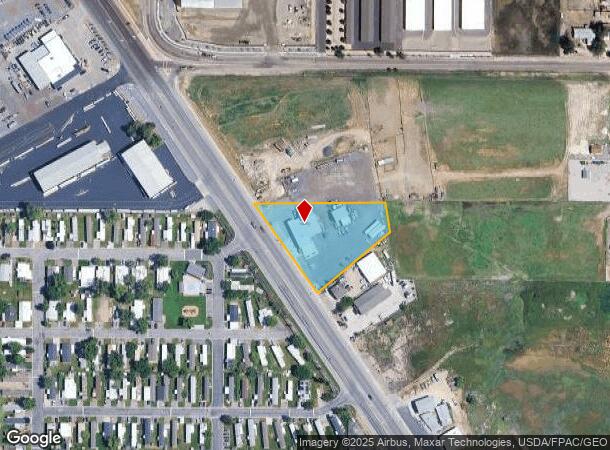
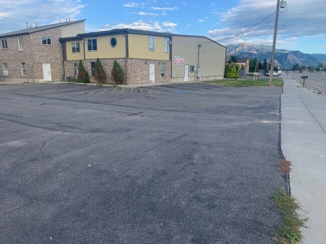
2458 N Highway 89, Ogden, UT 84404


NEARBY LISTINGS FOR SALE OR LEASE
Property Detail
2458 N Highway 89
Ogden-Clearfield, UT
Farber Phase 1 Subdivision
17-066-0001
A PORTION OF LOTS 5 AND 6, KING PLACE ADDITION, WEBER COUNTY UTAH, LYING EAST OF THE STATE ROAD. BEGINNING AT A POINT WHERE
Autorepair
Weber
X
Utah
49057C0200F
5-6
2025
1.42 AC
2025
Davis North
210305
Salt Lake City
13,000 SF
DEMOGRAPHICS near 2458 N Highway 89
1 Mile
3 Mile
5 Mile
2024 Total Population
7,115
57,331
99,574
2029 Population
7,765
61,822
107,388
Pop Growth 2024-2029
+ 9.14%
+ 7.83%
+ 7.85%
Average Age
32
36
36
2024 Total Households
2,247
18,086
32,415
HH Growth 2024-2029
+ 9.35%
+ 8.01%
+ 8.02%
Median Household Inc
$62,670
$88,035
$76,157
Avg Household Size
3.10
3.10
3.00
2024 Avg HH Vehicles
2.00
2.00
2.00
Median Home Value
$356,317
$384,496
$373,525
Median Year Built
2004
1998
1992
Nearby Places
Map Layers
Map Styles
 Street
 Aerial
- Restaurants
- Banks
- Shops
- Fitness
- Groceries
PUBLIC TRANSPORTATION
COMMUTER RAIL
Ogden (FrontRunner North - Utah Transit Authority (UTA))
DRIVE
WALK
Distance
Ogden (FrontRunner North - Utah Transit Authority (UTA))
11 min
5.9 mi
Freight Ports
Port of Stockton
DRIVE
WALK
Distance
Port of Stockton
754 min
736.4 mi
SALE & LEASE HISTORY
LISTING DATE
SALE/LEASE

Nov 14, 2022
For Lease
Jun 03, 2020
For Lease
Apr 02, 2021
For Lease
Nearby Properties
Address
Land Use
TOTAL SIZE
Lot Size
Zoning
Address
Land Use
TOTAL SIZE
Lot Size
Zoning
1,154,674 SF
133.48 AC
Address
Land Use
TOTAL SIZE
Lot Size
Zoning
1,001,933 SF
40.73 AC
Address
Land Use
TOTAL SIZE
Lot Size
Zoning
104,868 SF
22.96 AC
Address
Land Use
TOTAL SIZE
Lot Size
Zoning
292,940 SF
17.83 AC
Address
Land Use
TOTAL SIZE
Lot Size
Zoning
108,917 SF
13.90 AC
Address
Land Use
TOTAL SIZE
Lot Size
Zoning
183,172 SF
47.62 AC
Address
Land Use
TOTAL SIZE
Lot Size
Zoning
292,900 SF
14.54 AC
Address
Land Use
TOTAL SIZE
Lot Size
Zoning
264,373 SF
13.52 AC
Address
Land Use
TOTAL SIZE
Lot Size
Zoning
596 SF
8.08 AC
Address
Land Use
TOTAL SIZE
Lot Size
Zoning
202,499 SF
20.48 AC
Address
Land Use
TOTAL SIZE
Lot Size
Zoning
1,840 SF
127.86 AC
Address
Land Use
TOTAL SIZE
Lot Size
Zoning
247,962 SF
19.14 AC
Address
Land Use
TOTAL SIZE
Lot Size
Zoning
7,632 SF
6.87 AC
Address
Land Use
TOTAL SIZE
Lot Size
Zoning
228,832 SF
4.61 AC
Address
Land Use
TOTAL SIZE
Lot Size
Zoning
298,546 SF
12.66 AC
Address
Land Use
TOTAL SIZE
Lot Size
Zoning
296,653 SF
11.45 AC
Address
Land Use
TOTAL SIZE
Lot Size
Zoning
26,418 SF
9.81 AC
Address
Land Use
TOTAL SIZE
Lot Size
Zoning
45,534 SF
7.07 AC
Address
Land Use
TOTAL SIZE
Lot Size
Zoning
178,655 SF
11.61 AC
Address
Land Use
TOTAL SIZE
Lot Size
Zoning
21,756 SF
2.32 AC
Address
Land Use
TOTAL SIZE
Lot Size
Zoning
4,686 SF
28.74 AC
Address
Land Use
TOTAL SIZE
Lot Size
Zoning
102,522 SF
13.14 AC
Address
Land Use
TOTAL SIZE
Lot Size
Zoning
130,740 SF
21.64 AC
Address
Land Use
TOTAL SIZE
Lot Size
Zoning
9,744 SF
3.15 AC
The World's #1 Commercial Real Estate Marketplace
Connect with us
© 2025 CoStar Group
The information above has been obtained from sources believed reliable. While we do not doubt its accuracy we have not verified it and make no guarantee, warranty or representation about it. It is your responsibility to independently confirm its accuracy and completeness. Any projections, opinions, assumptions, or estimates used are for example only and do not represent the current or future performance of the property. The value of this transaction to you depends on tax and other factors which should be evaluated by your tax, financial, and legal advisors. You and your advisors should conduct a careful, independent investigation of the property to determine to your satisfaction the suitability of the property for your needs.