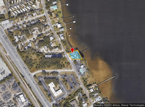
Property Record
2459 Pineapple Ave, Melbourne, FL 32935


NEARBY LISTINGS FOR SALE OR LEASE
Property Detail
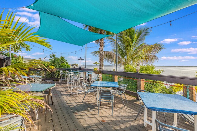
2459 Pineapple Ave
27-37-09-00-00520.0-0000.00
PART OF LOTS 2,3 AS DES IN ORB 594 PG 388
Restaurantbuilding
Brevard
X
Florida
12009C0519H
2,3
2024
0.40 AC
2025
Brevard County
064202
Orlando
3,271 SF
Palm Bay-Melbourne-Titusville, FL
DEMOGRAPHICS near 2459 Pineapple Ave
1 mile
3 mile
5 mile
2024 Total Population
6,910
59,023
116,602
2029 Population
7,491
64,168
127,116
Pop Growth 2024-2029
+ 8.41%
+ 8.72%
+ 9.02%
Average Age
43
44
45
2024 Total Households
3,155
26,024
50,799
HH Growth 2024-2029
+ 8.18%
+ 8.47%
+ 8.86%
Median Household Inc
$56,630
$65,509
$71,708
Avg Household Size
2.10
2.20
2.20
2024 Avg HH Vehicles
2.00
2.00
2.00
Median Home Value
$228,829
$262,821
$298,093
Median Year Built
1982
1980
1982
Nearby Places
Map Layers
Map Styles
 Street
 Aerial
Transit
 Traffic
 Biking
Places
Listings with unknown addresses are not visible on the map
- Restaurants
- Banks
- Shops
- Fitness
- Groceries
PUBLIC TRANSPORTATION
AIRPORT
Melbourne Orlando International
Drive
Walk
Distance
Melbourne Orlando International
15 min
6.4 mi
Freight Ports
Port Canaveral
Drive
Walk
Distance
Port Canaveral
40 min
22.2 mi
SALE & LEASE HISTORY
LISTING DATE
SALE/LEASE

Jul 27, 2022
For Sale
Nearby Properties
Address
Land Use
TOTAL SIZE
Lot Size
Zoning
Address
Land Use
TOTAL SIZE
Lot Size
Zoning
676,548 SF
117.62 AC
I1
Address
Land Use
TOTAL SIZE
Lot Size
Zoning
438,381 SF
25.66 AC
R2
Address
Land Use
TOTAL SIZE
Lot Size
Zoning
265,062 SF
14.75 AC
M1
Address
Land Use
TOTAL SIZE
Lot Size
Zoning
363,826 SF
25.61 AC
RA
Address
Land Use
TOTAL SIZE
Lot Size
Zoning
236,982 SF
39.26 AC
EU2
Address
Land Use
TOTAL SIZE
Lot Size
Zoning
672 SF
57.80 AC
I1
Address
Land Use
TOTAL SIZE
Lot Size
Zoning
269,111 SF
21.79 AC
PUD
Address
Land Use
TOTAL SIZE
Lot Size
Zoning
289,263 SF
13.96 AC
R2
Address
Land Use
TOTAL SIZE
Lot Size
Zoning
328,357 SF
34.11 AC
I1
Address
Land Use
TOTAL SIZE
Lot Size
Zoning
225,168 SF
7.06 AC
R3
Address
Land Use
TOTAL SIZE
Lot Size
Zoning
216,446 SF
14.09 AC
R2
Address
Land Use
TOTAL SIZE
Lot Size
Zoning
222,779 SF
22.58 AC
R2
Address
Land Use
TOTAL SIZE
Lot Size
Zoning
188,237 SF
13.97 AC
R2
Address
Land Use
TOTAL SIZE
Lot Size
Zoning
253,120 SF
16.02 AC
R2
Address
Land Use
TOTAL SIZE
Lot Size
Zoning
207,405 SF
28.05 AC
R26
Address
Land Use
TOTAL SIZE
Lot Size
Zoning
74,716 SF
366.45 AC
M1
Address
Land Use
TOTAL SIZE
Lot Size
Zoning
364,027 SF
22.91 AC
C2
Address
Land Use
TOTAL SIZE
Lot Size
Zoning
159,590 SF
26.66 AC
R26
Address
Land Use
TOTAL SIZE
Lot Size
Zoning
252,942 SF
29.76 AC
R3
Address
Land Use
TOTAL SIZE
Lot Size
Zoning
188,093 SF
13.11 AC
R2
Address
Land Use
TOTAL SIZE
Lot Size
Zoning
672 SF
261.50 AC
M1
Address
Land Use
TOTAL SIZE
Lot Size
Zoning
131,585 SF
10 AC
R2
Address
Land Use
TOTAL SIZE
Lot Size
Zoning
218,739 SF
11.23 AC
R2
Address
Land Use
TOTAL SIZE
Lot Size
Zoning
200,878 SF
16.41 AC
R2
Address
Land Use
TOTAL SIZE
Lot Size
Zoning
132,340 SF
14.58 AC
R2
Address
Land Use
TOTAL SIZE
Lot Size
Zoning
182,969 SF
14.64 AC
B1
Address
Land Use
TOTAL SIZE
Lot Size
Zoning
142,230 SF
13.33 AC
C1
Address
Land Use
TOTAL SIZE
Lot Size
Zoning
81,720 SF
13.20 AC
Address
Land Use
TOTAL SIZE
Lot Size
Zoning
35,696 SF
126.83 AC
M1
Address
Land Use
TOTAL SIZE
Lot Size
Zoning
171,773 SF
8.02 AC
R2
The World's #1 Commercial Real Estate Marketplace
Connect with us
© 2026 CoStar Group
The information above has been obtained from sources believed reliable. While we do not doubt its accuracy we have not verified it and make no guarantee, warranty or representation about it. It is your responsibility to independently confirm its accuracy and completeness. Any projections, opinions, assumptions, or estimates used are for example only and do not represent the current or future performance of the property. The value of this transaction to you depends on tax and other factors which should be evaluated by your tax, financial, and legal advisors. You and your advisors should conduct a careful, independent investigation of the property to determine to your satisfaction the suitability of the property for your needs.