No Photo
Property Record
2459 Shadagee Rd, Eden, NY 14057
NEARBY LISTINGS FOR SALE OR LEASE
-
-
View all Eden listings for sale on LoopNet.com
Property Detail
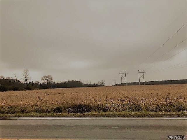
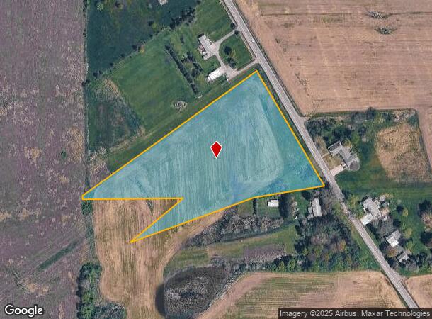
2459 Shadagee Rd
Buffalo-Cheektowaga-Niagara Falls, NY
Holland Land Companys Survey
144000-208-000-0005-013-200
Erie
Residentialacreage
New York
X
13.200
36029C0470H
5.34 AC
2025
Outlying Erie County
2024
Buffalo/Niagara Falls
015301
DEMOGRAPHICS near 2459 Shadagee Rd
1 Mile
3 Mile
5 Mile
2024 Total Population
296
9,194
33,528
2029 Population
296
9,154
33,514
Pop Growth 2024-2029
0.00%
(0.44%)
(0.04%)
Average Age
43
42
43
2024 Total Households
114
3,404
13,165
HH Growth 2024-2029
(0.88%)
(0.50%)
(0.11%)
Median Household Inc
$83,035
$100,574
$92,483
Avg Household Size
2.50
2.60
2.50
2024 Avg HH Vehicles
2.00
2.00
2.00
Median Home Value
$276,315
$251,974
$242,514
Median Year Built
1958
1972
1970
Nearby Places
- Restaurants
- Banks
- Shops
- Fitness
- Groceries
PUBLIC TRANSPORTATION
AIRPORT
Buffalo Niagara International
DRIVE
WALK
Distance
Buffalo Niagara International
45 min
27.3 mi
Niagara Falls International
DRIVE
WALK
Distance
Niagara Falls International
61 min
37.5 mi
Freight Ports
Port of Toledo
DRIVE
WALK
Distance
Port of Toledo
345 min
288.1 mi
SALE & LEASE HISTORY
LISTING DATE
SALE/LEASE

Jan 18, 2019
For Sale
Nearby Properties
Address
Land Use
TOTAL SIZE
Lot Size
Zoning
Address
Land Use
TOTAL SIZE
Lot Size
Zoning
407.90 AC
Address
Land Use
TOTAL SIZE
Lot Size
Zoning
104,945 SF
48 AC
05 - COMME
Address
Land Use
TOTAL SIZE
Lot Size
Zoning
175,723 SF
72.40 AC
02 - SINGL
Address
Land Use
TOTAL SIZE
Lot Size
Zoning
0.13 AC
Address
Land Use
TOTAL SIZE
Lot Size
Zoning
Address
Land Use
TOTAL SIZE
Lot Size
Zoning
Address
Land Use
TOTAL SIZE
Lot Size
Zoning
5,690 SF
10.22 AC
Address
Land Use
TOTAL SIZE
Lot Size
Zoning
7,429 SF
7.46 AC
05 - COMME
Address
Land Use
TOTAL SIZE
Lot Size
Zoning
Address
Land Use
TOTAL SIZE
Lot Size
Zoning
30,508 SF
Address
Land Use
TOTAL SIZE
Lot Size
Zoning
4,000 SF
7.10 AC
Address
Land Use
TOTAL SIZE
Lot Size
Zoning
7,200 SF
22 AC
PR
Address
Land Use
TOTAL SIZE
Lot Size
Zoning
35,818 SF
29.67 AC
05 - COMME
Address
Land Use
TOTAL SIZE
Lot Size
Zoning
40,233 SF
36 AC
Address
Land Use
TOTAL SIZE
Lot Size
Zoning
5,711 SF
141.40 AC
P
Address
Land Use
TOTAL SIZE
Lot Size
Zoning
20,885 SF
3.70 AC
03
Address
Land Use
TOTAL SIZE
Lot Size
Zoning
7,191 SF
11.74 AC
03 - MULTI
Address
Land Use
TOTAL SIZE
Lot Size
Zoning
13,519 SF
8.55 AC
04 - FARM
Address
Land Use
TOTAL SIZE
Lot Size
Zoning
49.70 AC
Address
Land Use
TOTAL SIZE
Lot Size
Zoning
0.23 AC
Address
Land Use
TOTAL SIZE
Lot Size
Zoning
118,584 SF
40 AC
05 - COMME
Address
Land Use
TOTAL SIZE
Lot Size
Zoning
10,500 SF
12.32 AC
Address
Land Use
TOTAL SIZE
Lot Size
Zoning
13,381 SF
4.05 AC
Address
Land Use
TOTAL SIZE
Lot Size
Zoning
5,788 SF
2.27 AC
02 - SINGL
Address
Land Use
TOTAL SIZE
Lot Size
Zoning
5,955 SF
41.90 AC
01 - NOT Z
Address
Land Use
TOTAL SIZE
Lot Size
Zoning
4,740 SF
0.91 AC
01 - NOT Z
Address
Land Use
TOTAL SIZE
Lot Size
Zoning
5,191 SF
3.71 AC
RA
Address
Land Use
TOTAL SIZE
Lot Size
Zoning
10,000 SF
2.85 AC
02 - SINGL
Address
Land Use
TOTAL SIZE
Lot Size
Zoning
8,276 SF
18.04 AC
Address
Land Use
TOTAL SIZE
Lot Size
Zoning
8,353 SF
1.30 AC
The World's #1 Commercial Real Estate Marketplace
Connect with us
© 2025 CoStar Group
The information above has been obtained from sources believed reliable. While we do not doubt its accuracy we have not verified it and make no guarantee, warranty or representation about it. It is your responsibility to independently confirm its accuracy and completeness. Any projections, opinions, assumptions, or estimates used are for example only and do not represent the current or future performance of the property. The value of this transaction to you depends on tax and other factors which should be evaluated by your tax, financial, and legal advisors. You and your advisors should conduct a careful, independent investigation of the property to determine to your satisfaction the suitability of the property for your needs.