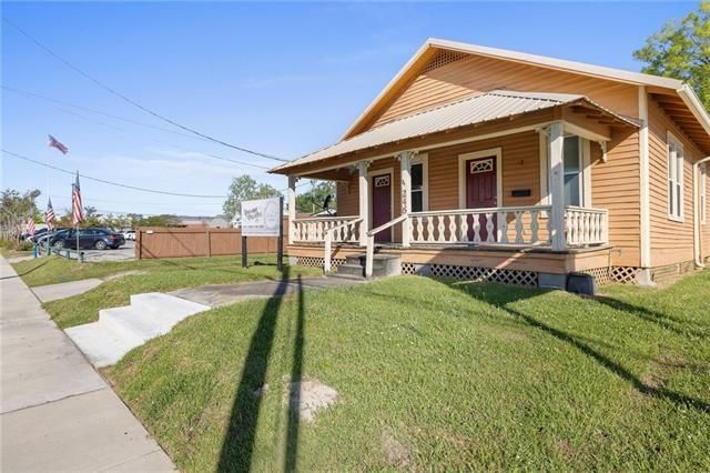
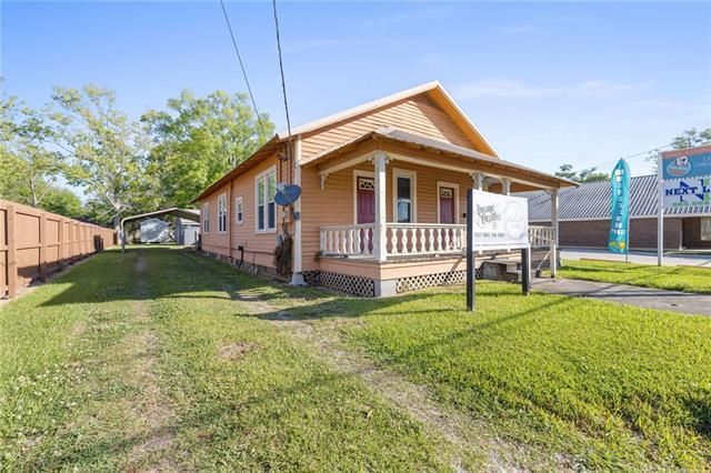
Property Record
246 E Pine St, Ponchatoula, LA 70454

Property Detail
246 E Pine St
Hammond, LA
0.12A MEAS 50 FT X 105 FT BEING E12 OF W12 OF LOTS 6-7-8 SQ 34 PONCH B451 P829 B768 P550 B1401 P15 B1402 P443 MAP 143216 1651
01693506
Tangipahoa
Commercialnec
Louisiana
B and X Area of moderate flood hazard, usually the area between the limits of the 100-year and 500-year floods.
6-8
2025
0.12 AC
2025
Louisiana South Area
954504
Other Market Areas
1,980 SF
NEARBY LISTINGS FOR SALE OR LEASE
-
-
View all Ponchatoula listings for sale on LoopNet.com
DEMOGRAPHICS near 246 E Pine St
1 mile
3 mile
5 mile
2025 Total Population
6,378
19,525
49,308
2030 Population
6,629
20,264
51,235
Pop Growth 2025-2030
+ 3.94%
+ 3.78%
+ 3.91%
Average Age
39
39
39
2025 Total Households
2,563
7,717
19,333
HH Growth 2025-2030
+ 4.10%
+ 3.93%
+ 4.10%
Median Household Inc
$60,577
$64,427
$59,267
Avg Household Size
2.50
2.50
2.50
2025 Avg HH Vehicles
2.00
2.00
2.00
Median Home Value
$233,638
$233,996
$240,116
Median Year Built
1992
2001
1999
Nearby Places
Map Layers
Map Styles
 Street
 Aerial
Transit
 Traffic
 Biking
Places
Listings with unknown addresses are not visible on the map
- Restaurants
- Banks
- Shops
- Fitness
- Groceries
PUBLIC TRANSPORTATION
COMMUTER RAIL
Drive
Walk
Distance
9 min
5.9 mi
AIRPORT
Louis Armstrong New Orleans International
Drive
Walk
Distance
Louis Armstrong New Orleans International
47 min
38.7 mi
SALE & LEASE HISTORY
LISTING DATE
SALE/LEASE

Apr 20, 2023
For Sale
Nearby Properties
Address
Land Use
TOTAL SIZE
Lot Size
Zoning
Address
Land Use
TOTAL SIZE
Lot Size
Zoning
22.56 AC
Address
Land Use
TOTAL SIZE
Lot Size
Zoning
327,625 SF
14.78 AC
Address
Land Use
TOTAL SIZE
Lot Size
Zoning
152,841 SF
20.69 AC
Address
Land Use
TOTAL SIZE
Lot Size
Zoning
84,000 SF
8.32 AC
Address
Land Use
TOTAL SIZE
Lot Size
Zoning
82,860 SF
11.42 AC
Address
Land Use
TOTAL SIZE
Lot Size
Zoning
24,931 SF
2.67 AC
Address
Land Use
TOTAL SIZE
Lot Size
Zoning
24,823 SF
3 AC
Address
Land Use
TOTAL SIZE
Lot Size
Zoning
36,593 SF
1.54 AC
Address
Land Use
TOTAL SIZE
Lot Size
Zoning
27,215 SF
7.58 AC
Address
Land Use
TOTAL SIZE
Lot Size
Zoning
96,064 SF
5.03 AC
Address
Land Use
TOTAL SIZE
Lot Size
Zoning
20,128 SF
20.77 AC
Address
Land Use
TOTAL SIZE
Lot Size
Zoning
22,507 SF
0.63 AC
Address
Land Use
TOTAL SIZE
Lot Size
Zoning
35,100 SF
3.20 AC
Address
Land Use
TOTAL SIZE
Lot Size
Zoning
120,800 SF
10 AC
Address
Land Use
TOTAL SIZE
Lot Size
Zoning
10,753 SF
1.57 AC
Address
Land Use
TOTAL SIZE
Lot Size
Zoning
24,040 SF
2.08 AC
Address
Land Use
TOTAL SIZE
Lot Size
Zoning
80,000 SF
11.02 AC
Address
Land Use
TOTAL SIZE
Lot Size
Zoning
57,587 SF
7.98 AC
Address
Land Use
TOTAL SIZE
Lot Size
Zoning
10,944 SF
2.16 AC
Address
Land Use
TOTAL SIZE
Lot Size
Zoning
16,780 SF
8.41 AC
Address
Land Use
TOTAL SIZE
Lot Size
Zoning
12,074 SF
45.70 AC
Address
Land Use
TOTAL SIZE
Lot Size
Zoning
236,540 SF
36.01 AC
Address
Land Use
TOTAL SIZE
Lot Size
Zoning
13,288 SF
15.07 AC
Address
Land Use
TOTAL SIZE
Lot Size
Zoning
67,728 SF
6.78 AC
Address
Land Use
TOTAL SIZE
Lot Size
Zoning
96,000 SF
7.29 AC
Address
Land Use
TOTAL SIZE
Lot Size
Zoning
12,021 SF
1.15 AC
Address
Land Use
TOTAL SIZE
Lot Size
Zoning
10,692 SF
5.49 AC
Address
Land Use
TOTAL SIZE
Lot Size
Zoning
31,750 SF
3.53 AC
Address
Land Use
TOTAL SIZE
Lot Size
Zoning
51,390 SF
16 AC
Address
Land Use
TOTAL SIZE
Lot Size
Zoning
8,700 SF
1.75 AC
The World's #1 Commercial Real Estate Marketplace
Connect with us
© 2026 CoStar Group
The information above has been obtained from sources believed reliable. While we do not doubt its accuracy we have not verified it and make no guarantee, warranty or representation about it. It is your responsibility to independently confirm its accuracy and completeness. Any projections, opinions, assumptions, or estimates used are for example only and do not represent the current or future performance of the property. The value of this transaction to you depends on tax and other factors which should be evaluated by your tax, financial, and legal advisors. You and your advisors should conduct a careful, independent investigation of the property to determine to your satisfaction the suitability of the property for your needs.