Property Record
2460 Spring Rd, Gainesville, GA 30504
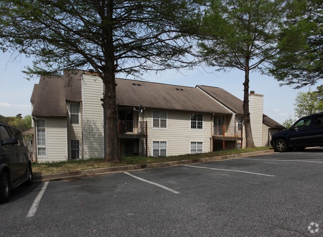

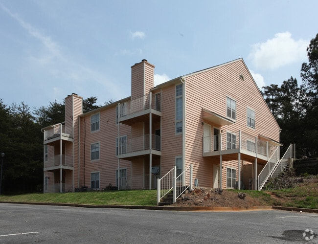

Property Detail
2460 Spring Rd
08-00005-00-056
2460 SPRING ROAD NW
Officebuilding
Hall
R-II
Georgia
B and X Area of moderate flood hazard, usually the area between the limits of the 100-year and 500-year floods.
6.69 AC
2025
Gainesville
2025
Atlanta
001008
Gainesville, GA
1,610 SF
NEARBY LISTINGS FOR SALE OR LEASE
DEMOGRAPHICS near 2460 Spring Rd
1 mile
3 mile
5 mile
2025 Total Population
6,995
44,988
86,151
2030 Population
7,537
48,664
93,548
Pop Growth 2025-2030
+ 7.75%
+ 8.17%
+ 8.59%
Average Age
34
37
38
2025 Total Households
2,404
15,285
30,603
HH Growth 2025-2030
+ 7.65%
+ 8.20%
+ 8.67%
Median Household Inc
$48,895
$65,014
$67,649
Avg Household Size
2.80
2.80
2.70
2025 Avg HH Vehicles
2.00
2.00
2.00
Median Home Value
$351,851
$331,810
$354,260
Median Year Built
1995
1989
1991
Nearby Places
Map Layers
Map Styles
 Street
 Aerial
Layers
 Traffic
 Biking
Places
Listings with unknown addresses are not visible on the map
- Restaurants
- Banks
- Shops
- Fitness
- Groceries
PUBLIC TRANSPORTATION
COMMUTER RAIL
Gainesville Amtrak Station (Crescent - Amtrak)
Drive
Walk
Distance
Gainesville Amtrak Station (Crescent - Amtrak)
6 min
3.8 mi
Freight Ports
Georgia Ports - Savannah
Drive
Walk
Distance
Georgia Ports - Savannah
321 min
254.0 mi
Nearby Properties
Address
Land Use
TOTAL SIZE
Lot Size
Zoning
Address
Land Use
TOTAL SIZE
Lot Size
Zoning
564,132 SF
48.45 AC
PUD
Address
Land Use
TOTAL SIZE
Lot Size
Zoning
66,720 SF
27.49 AC
PUD
Address
Land Use
TOTAL SIZE
Lot Size
Zoning
157,050 SF
144.96 AC
N-B
Address
Land Use
TOTAL SIZE
Lot Size
Zoning
27,221 SF
2.23 AC
G-B
Address
Land Use
TOTAL SIZE
Lot Size
Zoning
2,160 SF
5.60 AC
PUD
Address
Land Use
TOTAL SIZE
Lot Size
Zoning
58,020 SF
3.15 AC
PUD
Address
Land Use
TOTAL SIZE
Lot Size
Zoning
3,620 SF
20.20 AC
PUD
Address
Land Use
TOTAL SIZE
Lot Size
Zoning
100,864 SF
4.10 AC
PUD
Address
Land Use
TOTAL SIZE
Lot Size
Zoning
41,471 SF
27.60 AC
G-B/R-1
Address
Land Use
TOTAL SIZE
Lot Size
Zoning
77,333 SF
11.74 AC
PUD
Address
Land Use
TOTAL SIZE
Lot Size
Zoning
19,875 SF
19.76 AC
R-B
Address
Land Use
TOTAL SIZE
Lot Size
Zoning
56,780 SF
16.78 AC
PUD
Address
Land Use
TOTAL SIZE
Lot Size
Zoning
76,726 SF
0.42 AC
C-B
Address
Land Use
TOTAL SIZE
Lot Size
Zoning
132,557 SF
32.85 AC
O-I
Address
Land Use
TOTAL SIZE
Lot Size
Zoning
469,180 SF
25.56 AC
H-I
Address
Land Use
TOTAL SIZE
Lot Size
Zoning
11,430 SF
38 AC
R-I
Address
Land Use
TOTAL SIZE
Lot Size
Zoning
258,372 SF
24.38 AC
L-I
Address
Land Use
TOTAL SIZE
Lot Size
Zoning
308,672 SF
41.22 AC
L-I
Address
Land Use
TOTAL SIZE
Lot Size
Zoning
1,191 SF
262.63 AC
H-I
Address
Land Use
TOTAL SIZE
Lot Size
Zoning
1,441 SF
10.46 AC
PUD
Address
Land Use
TOTAL SIZE
Lot Size
Zoning
304,088 SF
17.45 AC
H-I
Address
Land Use
TOTAL SIZE
Lot Size
Zoning
140,805 SF
3.74 AC
PUD
Address
Land Use
TOTAL SIZE
Lot Size
Zoning
123,944 SF
13.21 AC
G-B
Address
Land Use
TOTAL SIZE
Lot Size
Zoning
1,628 SF
10.41 AC
PUD
Address
Land Use
TOTAL SIZE
Lot Size
Zoning
1,392 SF
22.44 AC
PUD
Address
Land Use
TOTAL SIZE
Lot Size
Zoning
60,062 SF
0.51 AC
C-B
Address
Land Use
TOTAL SIZE
Lot Size
Zoning
67,383 SF
1.68 AC
C-B
Address
Land Use
TOTAL SIZE
Lot Size
Zoning
301,380 SF
16.76 AC
I-1
Address
Land Use
TOTAL SIZE
Lot Size
Zoning
231,966 SF
0.95 AC
C-B
Address
Land Use
TOTAL SIZE
Lot Size
Zoning
12,200 SF
0.30 AC
C-B
The World's #1 Commercial Real Estate Marketplace
Connect with us
© 2026 CoStar Group
The information above has been obtained from sources believed reliable. While we do not doubt its accuracy we have not verified it and make no guarantee, warranty or representation about it. It is your responsibility to independently confirm its accuracy and completeness. Any projections, opinions, assumptions, or estimates used are for example only and do not represent the current or future performance of the property. The value of this transaction to you depends on tax and other factors which should be evaluated by your tax, financial, and legal advisors. You and your advisors should conduct a careful, independent investigation of the property to determine to your satisfaction the suitability of the property for your needs.