Property Record
2461 Route 9, Garrison, NY 10524


Property Detail
2461 Route 9
372689-049-000-0003-079-000-0000
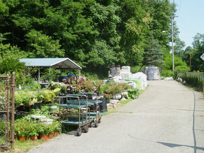
LAND & GARDEN CENTER
Storebuilding
Putnam
R80
New York
B and X Area of moderate flood hazard, usually the area between the limits of the 100-year and 500-year floods.
79.00
2024
1.32 AC
2025
Carmel
010600
Westchester/So Connecticut
6,672 SF
New York-Jersey City-White Plains, NY-NJ
NEARBY LISTINGS FOR SALE OR LEASE
DEMOGRAPHICS near 2461 Route 9
1 mile
3 mile
5 mile
2025 Total Population
387
6,435
24,249
2030 Population
391
6,526
24,749
Pop Growth 2025-2030
+ 1.03%
+ 1.41%
+ 2.06%
Average Age
46
43
38
2025 Total Households
145
2,382
7,449
HH Growth 2025-2030
+ 1.38%
+ 1.43%
+ 2.22%
Median Household Inc
$157,895
$131,423
$125,330
Avg Household Size
2.50
2.40
2.60
2025 Avg HH Vehicles
2.00
2.00
2.00
Median Home Value
$796,052
$693,587
$560,349
Median Year Built
1977
1962
1959
Nearby Places
Map Layers
Map Styles
 Street
 Aerial
Layers
 Traffic
 Biking
Places
Listings with unknown addresses are not visible on the map
- Restaurants
- Banks
- Shops
- Fitness
- Groceries
PUBLIC TRANSPORTATION
COMMUTER RAIL
Cold Spring Station (Hudson Line - Metro-North Commuter Railroad Company (Metro-North))
Drive
Walk
Distance
Cold Spring Station (Hudson Line - Metro-North Commuter Railroad Company (Metro-North))
9 min
4.8 mi
Garrison Station (Hudson Line - Metro-North Commuter Railroad Company (Metro-North))
Drive
Walk
Distance
Garrison Station (Hudson Line - Metro-North Commuter Railroad Company (Metro-North))
10 min
5.2 mi
AIRPORT
New York Stewart International
Drive
Walk
Distance
New York Stewart International
33 min
23.0 mi
Westchester County
Drive
Walk
Distance
Westchester County
52 min
38.2 mi
SALE & LEASE HISTORY
LISTING DATE
SALE/LEASE

Sep 24, 2016
For Sale
Aug 11, 2019
For Sale
Aug 09, 2017
For Sale
Apr 10, 2017
For Sale
Nearby Properties
Address
Land Use
TOTAL SIZE
Lot Size
Zoning
Address
Land Use
TOTAL SIZE
Lot Size
Zoning
119,474 SF
214.27 AC
R80
Address
Land Use
TOTAL SIZE
Lot Size
Zoning
100,369 SF
11.96 AC
R10
Address
Land Use
TOTAL SIZE
Lot Size
Zoning
73,825 SF
76.04 AC
PC
Address
Land Use
TOTAL SIZE
Lot Size
Zoning
42,411 SF
5.17 AC
R10
Address
Land Use
TOTAL SIZE
Lot Size
Zoning
Address
Land Use
TOTAL SIZE
Lot Size
Zoning
2.07 AC
R120
Address
Land Use
TOTAL SIZE
Lot Size
Zoning
5,380 SF
8.16 AC
CD
Address
Land Use
TOTAL SIZE
Lot Size
Zoning
25,024 SF
178.89 AC
PD
Address
Land Use
TOTAL SIZE
Lot Size
Zoning
40,796 SF
125.03 AC
R80
Address
Land Use
TOTAL SIZE
Lot Size
Zoning
589.20 AC
PD
Address
Land Use
TOTAL SIZE
Lot Size
Zoning
44,052 SF
23.97 AC
R80
Address
Land Use
TOTAL SIZE
Lot Size
Zoning
12,747 SF
35.73 AC
R80
Address
Land Use
TOTAL SIZE
Lot Size
Zoning
Address
Land Use
TOTAL SIZE
Lot Size
Zoning
13,650 SF
16.46 AC
R80
Address
Land Use
TOTAL SIZE
Lot Size
Zoning
324 AC
R80
Address
Land Use
TOTAL SIZE
Lot Size
Zoning
21,120 SF
43.91 AC
R80
Address
Land Use
TOTAL SIZE
Lot Size
Zoning
Address
Land Use
TOTAL SIZE
Lot Size
Zoning
19,138 SF
8.49 AC
R40
Address
Land Use
TOTAL SIZE
Lot Size
Zoning
39,971 SF
10.39 AC
R10
Address
Land Use
TOTAL SIZE
Lot Size
Zoning
19,474 SF
9.39 AC
R40
Address
Land Use
TOTAL SIZE
Lot Size
Zoning
29,176 SF
66.77 AC
R80
Address
Land Use
TOTAL SIZE
Lot Size
Zoning
21,729 SF
7.32 AC
B1
Address
Land Use
TOTAL SIZE
Lot Size
Zoning
40,796 SF
2.33 AC
R80
Address
Land Use
TOTAL SIZE
Lot Size
Zoning
11,880 SF
5 AC
R80
Address
Land Use
TOTAL SIZE
Lot Size
Zoning
48,758 SF
3.51 AC
R10
Address
Land Use
TOTAL SIZE
Lot Size
Zoning
2,133 SF
130.76 AC
PD
Address
Land Use
TOTAL SIZE
Lot Size
Zoning
19,232 SF
0.52 AC
R10
Address
Land Use
TOTAL SIZE
Lot Size
Zoning
13,814 SF
2.94 AC
R10
Address
Land Use
TOTAL SIZE
Lot Size
Zoning
95.07 AC
R80
Address
Land Use
TOTAL SIZE
Lot Size
Zoning
4,552 SF
74.92 AC
CD
The World's #1 Commercial Real Estate Marketplace
Connect with us
© 2026 CoStar Group
The information above has been obtained from sources believed reliable. While we do not doubt its accuracy we have not verified it and make no guarantee, warranty or representation about it. It is your responsibility to independently confirm its accuracy and completeness. Any projections, opinions, assumptions, or estimates used are for example only and do not represent the current or future performance of the property. The value of this transaction to you depends on tax and other factors which should be evaluated by your tax, financial, and legal advisors. You and your advisors should conduct a careful, independent investigation of the property to determine to your satisfaction the suitability of the property for your needs.