Property Record
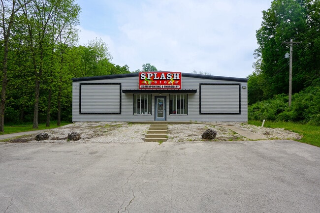
24610 Highway 17, Waynesville, MO 65583


NEARBY LISTINGS FOR SALE OR LEASE
-
-
View all Waynesville listings for sale on LoopNet.com
Property Detail
24610 Highway 17
11-8.0-34-003-002-014-001
PT NW SW4
Warehouse
Pulaski
X
Missouri
29169C0261D
1.10 AC
2024
Missouri South Central Area
2024
Other Market Areas
470402
Fort Leonard Wood, MO
6,250 SF
DEMOGRAPHICS near 24610 Highway 17
1 Mile
3 Mile
5 Mile
2024 Total Population
2,427
9,614
14,643
2029 Population
2,419
9,589
14,591
Pop Growth 2024-2029
(0.33%)
(0.26%)
(0.36%)
Average Age
38
36
36
2024 Total Households
992
3,718
5,616
HH Growth 2024-2029
(0.40%)
(0.35%)
(0.37%)
Median Household Inc
$61,440
$68,732
$67,423
Avg Household Size
2.40
2.50
2.50
2024 Avg HH Vehicles
2.00
2.00
2.00
Median Home Value
$172,413
$173,473
$165,062
Median Year Built
1981
1992
1995
Nearby Places
Map Layers
Map Styles
 Street
 Aerial
- Restaurants
- Banks
- Shops
- Fitness
- Groceries
SALE & LEASE HISTORY
LISTING DATE
SALE/LEASE

Jun 27, 2023
For Sale
Nearby Properties
Address
Land Use
TOTAL SIZE
Lot Size
Zoning
Address
Land Use
TOTAL SIZE
Lot Size
Zoning
71,476 SF
3.90 AC
Address
Land Use
TOTAL SIZE
Lot Size
Zoning
4.20 AC
Address
Land Use
TOTAL SIZE
Lot Size
Zoning
2,325 SF
2.40 AC
Address
Land Use
TOTAL SIZE
Lot Size
Zoning
4,608 SF
7.90 AC
Address
Land Use
TOTAL SIZE
Lot Size
Zoning
34,758 SF
3.40 AC
Address
Land Use
TOTAL SIZE
Lot Size
Zoning
6,480 SF
6.20 AC
Address
Land Use
TOTAL SIZE
Lot Size
Zoning
53,334 SF
5.20 AC
Address
Land Use
TOTAL SIZE
Lot Size
Zoning
2,904 SF
5.50 AC
Address
Land Use
TOTAL SIZE
Lot Size
Zoning
6,233 SF
4.10 AC
Address
Land Use
TOTAL SIZE
Lot Size
Zoning
7,152 SF
8.50 AC
Address
Land Use
TOTAL SIZE
Lot Size
Zoning
35,082 SF
2.70 AC
Address
Land Use
TOTAL SIZE
Lot Size
Zoning
11,674 SF
2.70 AC
Address
Land Use
TOTAL SIZE
Lot Size
Zoning
8,750 SF
1.50 AC
Address
Land Use
TOTAL SIZE
Lot Size
Zoning
23,200 SF
2 AC
Address
Land Use
TOTAL SIZE
Lot Size
Zoning
4,000 SF
5.50 AC
Address
Land Use
TOTAL SIZE
Lot Size
Zoning
10,329 SF
2.20 AC
Address
Land Use
TOTAL SIZE
Lot Size
Zoning
11,520 SF
40 AC
Address
Land Use
TOTAL SIZE
Lot Size
Zoning
4,500 SF
3.30 AC
Address
Land Use
TOTAL SIZE
Lot Size
Zoning
7,500 SF
5.50 AC
Address
Land Use
TOTAL SIZE
Lot Size
Zoning
74,218 SF
9.20 AC
Address
Land Use
TOTAL SIZE
Lot Size
Zoning
10,388 SF
1.70 AC
Address
Land Use
TOTAL SIZE
Lot Size
Zoning
7,320 SF
0.90 AC
Address
Land Use
TOTAL SIZE
Lot Size
Zoning
4,854 SF
6.20 AC
Address
Land Use
TOTAL SIZE
Lot Size
Zoning
9,301 SF
1.20 AC
Address
Land Use
TOTAL SIZE
Lot Size
Zoning
6,000 SF
0.70 AC
Address
Land Use
TOTAL SIZE
Lot Size
Zoning
3,723 SF
1 AC
Address
Land Use
TOTAL SIZE
Lot Size
Zoning
4,054 SF
1.20 AC
The World's #1 Commercial Real Estate Marketplace
Connect with us
© 2026 CoStar Group
The information above has been obtained from sources believed reliable. While we do not doubt its accuracy we have not verified it and make no guarantee, warranty or representation about it. It is your responsibility to independently confirm its accuracy and completeness. Any projections, opinions, assumptions, or estimates used are for example only and do not represent the current or future performance of the property. The value of this transaction to you depends on tax and other factors which should be evaluated by your tax, financial, and legal advisors. You and your advisors should conduct a careful, independent investigation of the property to determine to your satisfaction the suitability of the property for your needs.