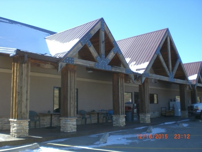
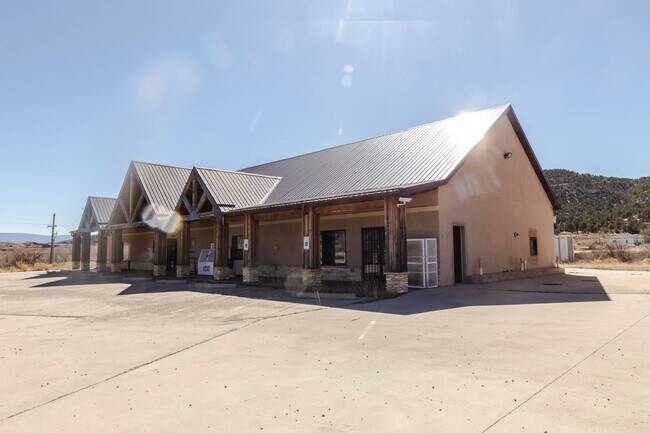
Property Record
24638 State Highway 12, Trinidad, CO 81082

Property Detail
24638 State Highway 12
14538000
31-33-65 PT-NWSE- BEG AT PT SW COR OF NWSE S84DEG 24 MIN W796.5FT TH N68DEG 01MIN E99.5FT TH N67DEG 36MIN E 319FT TH S50DEG19MIN E88.7FT TH S2DEG 19MIN E147.6FT TH N86DEG 29MIN W460 TH N5DEG 58MIN W18.6FT TO PL OF BEG CONT- 1.25 ACRE PLAT RECORED
Commercialnec
Las Animas
B and X Area of moderate flood hazard, usually the area between the limits of the 100-year and 500-year floods.
Colorado
2024
1.25 AC
2025
Colorado East Area
000300
Other Market Areas
7,630 SF
NEARBY LISTINGS FOR SALE OR LEASE
-
-
View all Trinidad listings for sale on LoopNet.com
DEMOGRAPHICS near 24638 State Highway 12
1 mile
3 mile
5 mile
2025 Total Population
80
310
527
2030 Population
82
316
536
Pop Growth 2025-2030
+ 2.50%
+ 1.94%
+ 1.71%
Average Age
54
53
52
2025 Total Households
39
147
249
HH Growth 2025-2030
+ 2.56%
+ 2.04%
+ 2.01%
Median Household Inc
$53,750
$49,749
$49,264
Avg Household Size
2.00
2.10
2.10
2025 Avg HH Vehicles
2.00
2.00
2.00
Median Home Value
$328,571
$303,571
$299,999
Median Year Built
1990
1985
1985
Nearby Places
Map Layers
Map Styles
 Street
 Aerial
Layers
 Traffic
 Biking
Places
Listings with unknown addresses are not visible on the map
- Restaurants
- Banks
- Shops
- Fitness
- Groceries
SALE & LEASE HISTORY
LISTING DATE
SALE/LEASE

Sep 24, 2016
For Sale
Mar 15, 2021
For Sale
Jun 07, 2023
For Sale
Aug 20, 2019
For Sale
Nearby Properties
Address
Land Use
TOTAL SIZE
Lot Size
Zoning
Address
Land Use
TOTAL SIZE
Lot Size
Zoning
93,600 SF
170.81 AC
Address
Land Use
TOTAL SIZE
Lot Size
Zoning
13,940 SF
361.80 AC
Address
Land Use
TOTAL SIZE
Lot Size
Zoning
Address
Land Use
TOTAL SIZE
Lot Size
Zoning
160 AC
Address
Land Use
TOTAL SIZE
Lot Size
Zoning
9,200 SF
5 AC
Address
Land Use
TOTAL SIZE
Lot Size
Zoning
Address
Land Use
TOTAL SIZE
Lot Size
Zoning
Address
Land Use
TOTAL SIZE
Lot Size
Zoning
155.24 AC
Address
Land Use
TOTAL SIZE
Lot Size
Zoning
Address
Land Use
TOTAL SIZE
Lot Size
Zoning
Address
Land Use
TOTAL SIZE
Lot Size
Zoning
1,200 SF
70.85 AC
Address
Land Use
TOTAL SIZE
Lot Size
Zoning
Address
Land Use
TOTAL SIZE
Lot Size
Zoning
2,760 SF
36.35 AC
Address
Land Use
TOTAL SIZE
Lot Size
Zoning
5,173 SF
5.63 AC
Address
Land Use
TOTAL SIZE
Lot Size
Zoning
4,184 SF
43.01 AC
Address
Land Use
TOTAL SIZE
Lot Size
Zoning
5,000 SF
3.82 AC
Address
Land Use
TOTAL SIZE
Lot Size
Zoning
57.54 AC
Address
Land Use
TOTAL SIZE
Lot Size
Zoning
2,974 SF
Address
Land Use
TOTAL SIZE
Lot Size
Zoning
3,966 SF
228.82 AC
Address
Land Use
TOTAL SIZE
Lot Size
Zoning
Address
Land Use
TOTAL SIZE
Lot Size
Zoning
Address
Land Use
TOTAL SIZE
Lot Size
Zoning
Address
Land Use
TOTAL SIZE
Lot Size
Zoning
Address
Land Use
TOTAL SIZE
Lot Size
Zoning
3,823 SF
17.74 AC
Address
Land Use
TOTAL SIZE
Lot Size
Zoning
The World's #1 Commercial Real Estate Marketplace
Connect with us
© 2026 CoStar Group
The information above has been obtained from sources believed reliable. While we do not doubt its accuracy we have not verified it and make no guarantee, warranty or representation about it. It is your responsibility to independently confirm its accuracy and completeness. Any projections, opinions, assumptions, or estimates used are for example only and do not represent the current or future performance of the property. The value of this transaction to you depends on tax and other factors which should be evaluated by your tax, financial, and legal advisors. You and your advisors should conduct a careful, independent investigation of the property to determine to your satisfaction the suitability of the property for your needs.