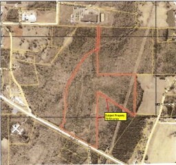
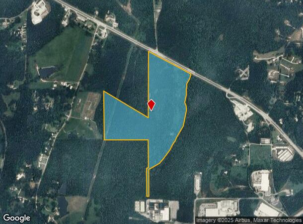
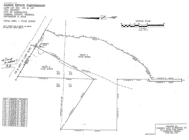
Property Record
2464 N Highway 27, Carrollton, GA 30117

NEARBY LISTINGS FOR SALE OR LEASE
Property Detail
2464 N Highway 27
C02-0430329
V/78.58AC HWY 27 N CTY89-1
Industrialgeneral
Carroll
A
Georgia
13045C0251D
78.58 AC
2025
W Carroll County
2025
Atlanta
910503
Atlanta-Sandy Springs-Roswell, GA
DEMOGRAPHICS near 2464 N Highway 27
1 Mile
3 Mile
5 Mile
2024 Total Population
731
12,363
39,381
2029 Population
831
13,726
43,738
Pop Growth 2024-2029
+ 13.68%
+ 11.02%
+ 11.06%
Average Age
37
35
35
2024 Total Households
254
4,512
14,146
HH Growth 2024-2029
+ 13.78%
+ 11.08%
+ 11.25%
Median Household Inc
$45,988
$45,889
$45,798
Avg Household Size
2.80
2.70
2.60
2024 Avg HH Vehicles
2.00
2.00
2.00
Median Home Value
$195,160
$172,119
$199,071
Median Year Built
1999
1989
1985
Nearby Places
Map Layers
Map Styles
 Street
 Aerial
- Restaurants
- Banks
- Shops
- Fitness
- Groceries
SALE & LEASE HISTORY
LISTING DATE
SALE/LEASE

Sep 24, 2016
For Sale
Sep 19, 2019
For Sale
Nearby Properties
Address
Land Use
TOTAL SIZE
Lot Size
Zoning
Address
Land Use
TOTAL SIZE
Lot Size
Zoning
932,068 SF
150.44 AC
I
Address
Land Use
TOTAL SIZE
Lot Size
Zoning
452,050 SF
34 AC
M2
Address
Land Use
TOTAL SIZE
Lot Size
Zoning
820,922 SF
84.15 AC
M2
Address
Land Use
TOTAL SIZE
Lot Size
Zoning
44,708 SF
9.92 AC
RESIDENTIA
Address
Land Use
TOTAL SIZE
Lot Size
Zoning
162,506 SF
23.32 AC
M2
Address
Land Use
TOTAL SIZE
Lot Size
Zoning
12,752 SF
15.63 AC
R3
Address
Land Use
TOTAL SIZE
Lot Size
Zoning
23,801 SF
14.78 AC
PD/R-M
Address
Land Use
TOTAL SIZE
Lot Size
Zoning
162,219 SF
31 AC
M2
Address
Land Use
TOTAL SIZE
Lot Size
Zoning
13,185 SF
26.29 AC
R4
Address
Land Use
TOTAL SIZE
Lot Size
Zoning
17,102 SF
33.57 AC
R3
Address
Land Use
TOTAL SIZE
Lot Size
Zoning
17,000 SF
13.52 AC
R3
Address
Land Use
TOTAL SIZE
Lot Size
Zoning
69,336 SF
25.63 AC
M1
Address
Land Use
TOTAL SIZE
Lot Size
Zoning
170,850 SF
10.97 AC
M2
Address
Land Use
TOTAL SIZE
Lot Size
Zoning
341,714 SF
44.49 AC
M2
Address
Land Use
TOTAL SIZE
Lot Size
Zoning
101,000 SF
15 AC
RESIDENTIA
Address
Land Use
TOTAL SIZE
Lot Size
Zoning
90,800 SF
10.89 AC
C2
Address
Land Use
TOTAL SIZE
Lot Size
Zoning
128,000 SF
0.74 AC
M2
Address
Land Use
TOTAL SIZE
Lot Size
Zoning
117,105 SF
8.74 AC
M2
Address
Land Use
TOTAL SIZE
Lot Size
Zoning
9,891 SF
11.54 AC
R3
Address
Land Use
TOTAL SIZE
Lot Size
Zoning
109,300 SF
127 AC
I
Address
Land Use
TOTAL SIZE
Lot Size
Zoning
39,500 SF
15.36 AC
OI
Address
Land Use
TOTAL SIZE
Lot Size
Zoning
64,000 SF
0.24 AC
M2
Address
Land Use
TOTAL SIZE
Lot Size
Zoning
7,208 SF
9.87 AC
R3
Address
Land Use
TOTAL SIZE
Lot Size
Zoning
75,840 SF
6.90 AC
M2
Address
Land Use
TOTAL SIZE
Lot Size
Zoning
25,341 SF
3.54 AC
C2
Address
Land Use
TOTAL SIZE
Lot Size
Zoning
101.95 AC
RESIDENTIA
Address
Land Use
TOTAL SIZE
Lot Size
Zoning
39,147 SF
9 AC
R2
Address
Land Use
TOTAL SIZE
Lot Size
Zoning
138,320 SF
16.67 AC
M2
Address
Land Use
TOTAL SIZE
Lot Size
Zoning
13,632 SF
5 AC
R2
Address
Land Use
TOTAL SIZE
Lot Size
Zoning
40,000 SF
The World's #1 Commercial Real Estate Marketplace
Connect with us
© 2025 CoStar Group
The information above has been obtained from sources believed reliable. While we do not doubt its accuracy we have not verified it and make no guarantee, warranty or representation about it. It is your responsibility to independently confirm its accuracy and completeness. Any projections, opinions, assumptions, or estimates used are for example only and do not represent the current or future performance of the property. The value of this transaction to you depends on tax and other factors which should be evaluated by your tax, financial, and legal advisors. You and your advisors should conduct a careful, independent investigation of the property to determine to your satisfaction the suitability of the property for your needs.