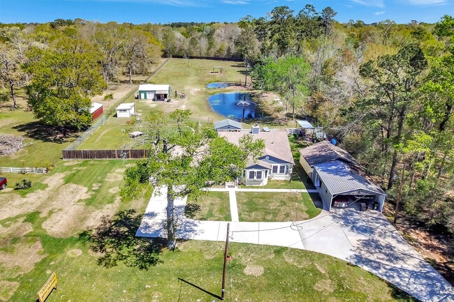
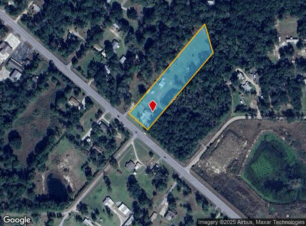
Property Record
24677 Fm 2090 Rd, Splendora, TX 77372
NEARBY LISTINGS FOR SALE OR LEASE
Property Detail
24677 Fm 2090 Rd
Houston-Pasadena-The Woodlands, TX
Splendora Farms 01
8940-01-01000
SPLENDORA FARMS 01, LOT 10 E/2, ACRES 2.880
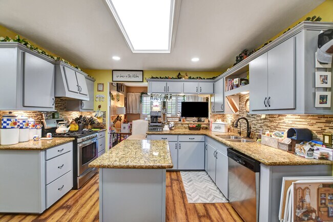
Sfr
Montgomery
X
Texas
48339C0600G
10
2024
2.88 AC
2025
Outlying Montgomery Cnty
692900
Houston
2,256 SF
DEMOGRAPHICS near 24677 Fm 2090 Rd
1 mile
3 mile
5 mile
2024 Total Population
1,542
10,787
35,268
2029 Population
2,312
16,267
54,512
Pop Growth 2024-2029
+ 49.94%
+ 50.80%
+ 54.57%
Average Age
37
37
38
2024 Total Households
509
3,540
11,666
HH Growth 2024-2029
+ 51.28%
+ 52.20%
+ 55.47%
Median Household Inc
$78,869
$68,660
$69,729
Avg Household Size
2.90
3.00
3.00
2024 Avg HH Vehicles
2.00
2.00
2.00
Median Home Value
$193,892
$220,306
$215,452
Median Year Built
1994
1998
2001
Nearby Places
Map Layers
Map Styles
 Street
 Aerial
Transit
 Traffic
 Biking
Places
Listings with unknown addresses are not visible on the map
- Restaurants
- Banks
- Shops
- Fitness
- Groceries
PUBLIC TRANSPORTATION
AIRPORT
George Bush Intcntl/Houston
Drive
Walk
Distance
George Bush Intcntl/Houston
34 min
26.8 mi
Freight Ports
Port of Houston
Drive
Walk
Distance
Port of Houston
55 min
42.1 mi
SALE & LEASE HISTORY
LISTING DATE
SALE/LEASE

May 05, 2025
For Sale
Nearby Properties
Address
Land Use
TOTAL SIZE
Lot Size
Zoning
Address
Land Use
TOTAL SIZE
Lot Size
Zoning
154,508 SF
110.45 AC
Address
Land Use
TOTAL SIZE
Lot Size
Zoning
119,211 SF
23.86 AC
Address
Land Use
TOTAL SIZE
Lot Size
Zoning
132,680 SF
5 AC
5
Address
Land Use
TOTAL SIZE
Lot Size
Zoning
84,249 SF
38.34 AC
Address
Land Use
TOTAL SIZE
Lot Size
Zoning
97,193 SF
24.79 AC
5
Address
Land Use
TOTAL SIZE
Lot Size
Zoning
78,721 SF
22.26 AC
Address
Land Use
TOTAL SIZE
Lot Size
Zoning
26,348 SF
30.22 AC
5
Address
Land Use
TOTAL SIZE
Lot Size
Zoning
84,704 SF
4.47 AC
5
Address
Land Use
TOTAL SIZE
Lot Size
Zoning
30,916 SF
3.36 AC
Address
Land Use
TOTAL SIZE
Lot Size
Zoning
3,880 SF
13.32 AC
5
Address
Land Use
TOTAL SIZE
Lot Size
Zoning
19,684 SF
7.90 AC
5
Address
Land Use
TOTAL SIZE
Lot Size
Zoning
44,160 SF
10.98 AC
5
Address
Land Use
TOTAL SIZE
Lot Size
Zoning
58,972 SF
4.70 AC
5
Address
Land Use
TOTAL SIZE
Lot Size
Zoning
10,792 SF
2.70 AC
Address
Land Use
TOTAL SIZE
Lot Size
Zoning
237 SF
10.51 AC
5
Address
Land Use
TOTAL SIZE
Lot Size
Zoning
19,587 SF
3.50 AC
Address
Land Use
TOTAL SIZE
Lot Size
Zoning
10,640 SF
1.13 AC
Address
Land Use
TOTAL SIZE
Lot Size
Zoning
7,000 SF
4.51 AC
Address
Land Use
TOTAL SIZE
Lot Size
Zoning
36,490 SF
2.72 AC
5
Address
Land Use
TOTAL SIZE
Lot Size
Zoning
9,100 SF
1.71 AC
5
Address
Land Use
TOTAL SIZE
Lot Size
Zoning
23,990 SF
15 AC
5
Address
Land Use
TOTAL SIZE
Lot Size
Zoning
6,193 SF
4.84 AC
5
Address
Land Use
TOTAL SIZE
Lot Size
Zoning
25,300 SF
5.13 AC
Address
Land Use
TOTAL SIZE
Lot Size
Zoning
9,100 SF
1.18 AC
5
Address
Land Use
TOTAL SIZE
Lot Size
Zoning
49.40 AC
5
Address
Land Use
TOTAL SIZE
Lot Size
Zoning
5,600 SF
3.18 AC
5
Address
Land Use
TOTAL SIZE
Lot Size
Zoning
7,740 SF
1.32 AC
5
The World's #1 Commercial Real Estate Marketplace
Connect with us
© 2026 CoStar Group
The information above has been obtained from sources believed reliable. While we do not doubt its accuracy we have not verified it and make no guarantee, warranty or representation about it. It is your responsibility to independently confirm its accuracy and completeness. Any projections, opinions, assumptions, or estimates used are for example only and do not represent the current or future performance of the property. The value of this transaction to you depends on tax and other factors which should be evaluated by your tax, financial, and legal advisors. You and your advisors should conduct a careful, independent investigation of the property to determine to your satisfaction the suitability of the property for your needs.