Property Record
24688 Sorters Rd, Porter, TX 77365

Save to a Folder
{{folder.Name}}
{{folder.ListingIds.length}} Properties
{{folder.ListingIds.length}} Property
Create a New Folder
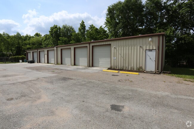
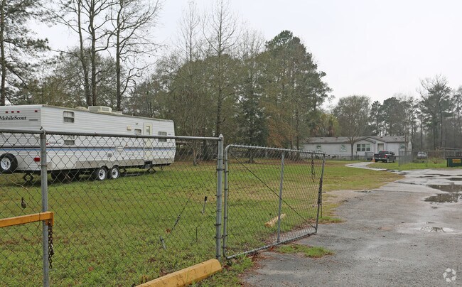
Property Detail
24688 Sorters Rd
0254-00-02700
A0254 - HOWELL ROBT F, TRACT 27, ACRES 2.9071
Commercialnec
Montgomery
5
Texas
B and X Area of moderate flood hazard, usually the area between the limits of the 100-year and 500-year floods.
2.91 AC
2024
The Woodlands/Conroe
2025
Houston
692303
Houston-Pasadena-The Woodlands, TX
6,628 SF
NEARBY LISTINGS FOR SALE OR LEASE
DEMOGRAPHICS near 24688 Sorters Rd
1 mile
3 mile
5 mile
2025 Total Population
4,579
36,962
109,741
2030 Population
5,349
43,472
125,790
Pop Growth 2025-2030
+ 16.82%
+ 17.61%
+ 14.62%
Average Age
39
37
37
2025 Total Households
1,562
13,674
38,324
HH Growth 2025-2030
+ 17.41%
+ 18.36%
+ 15.12%
Median Household Inc
$98,635
$89,757
$89,927
Avg Household Size
2.80
2.60
2.80
2025 Avg HH Vehicles
2.00
2.00
2.00
Median Home Value
$311,446
$313,638
$288,479
Median Year Built
2008
2010
2004
Nearby Places
Map Layers
Map Styles
 Street
 Aerial
Layers
 Traffic
 Biking
Places
Listings with unknown addresses are not visible on the map
- Restaurants
- Banks
- Shops
- Fitness
- Groceries
PUBLIC TRANSPORTATION
AIRPORT
George Bush Intcntl/Houston
Drive
Walk
Distance
George Bush Intcntl/Houston
23 min
15.4 mi
William P Hobby
Drive
Walk
Distance
William P Hobby
55 min
37.0 mi
Freight Ports
Port of Houston
Drive
Walk
Distance
Port of Houston
44 min
30.7 mi
Nearby Properties
Address
Land Use
TOTAL SIZE
Lot Size
Zoning
Address
Land Use
TOTAL SIZE
Lot Size
Zoning
363,730 SF
12.59 AC
Address
Land Use
TOTAL SIZE
Lot Size
Zoning
275,500 SF
13.58 AC
Address
Land Use
TOTAL SIZE
Lot Size
Zoning
407,266 SF
25.02 AC
Address
Land Use
TOTAL SIZE
Lot Size
Zoning
288,199 SF
15.50 AC
Address
Land Use
TOTAL SIZE
Lot Size
Zoning
392,395 SF
14.86 AC
5
Address
Land Use
TOTAL SIZE
Lot Size
Zoning
316,815 SF
15.61 AC
Address
Land Use
TOTAL SIZE
Lot Size
Zoning
341,175 SF
65.76 AC
5
Address
Land Use
TOTAL SIZE
Lot Size
Zoning
327,725 SF
22.04 AC
5
Address
Land Use
TOTAL SIZE
Lot Size
Zoning
374,791 SF
17.36 AC
Address
Land Use
TOTAL SIZE
Lot Size
Zoning
307,727 SF
14.93 AC
5
Address
Land Use
TOTAL SIZE
Lot Size
Zoning
343,814 SF
12.83 AC
Address
Land Use
TOTAL SIZE
Lot Size
Zoning
237,686 SF
6.53 AC
5
Address
Land Use
TOTAL SIZE
Lot Size
Zoning
274,809 SF
11.89 AC
Address
Land Use
TOTAL SIZE
Lot Size
Zoning
194,418 SF
6.93 AC
Address
Land Use
TOTAL SIZE
Lot Size
Zoning
237,552 SF
13.28 AC
5
Address
Land Use
TOTAL SIZE
Lot Size
Zoning
356,000 SF
67.95 AC
Address
Land Use
TOTAL SIZE
Lot Size
Zoning
235,072 SF
26.44 AC
5
Address
Land Use
TOTAL SIZE
Lot Size
Zoning
161,302 SF
60.09 AC
5
Address
Land Use
TOTAL SIZE
Lot Size
Zoning
215,554 SF
20.89 AC
5
Address
Land Use
TOTAL SIZE
Lot Size
Zoning
62,172 SF
6.02 AC
Address
Land Use
TOTAL SIZE
Lot Size
Zoning
38,994 SF
4.82 AC
5
Address
Land Use
TOTAL SIZE
Lot Size
Zoning
103,640 SF
13.92 AC
Address
Land Use
TOTAL SIZE
Lot Size
Zoning
139,838 SF
38.71 AC
Address
Land Use
TOTAL SIZE
Lot Size
Zoning
154,800 SF
3.10 AC
Address
Land Use
TOTAL SIZE
Lot Size
Zoning
63,549 SF
2.32 AC
Address
Land Use
TOTAL SIZE
Lot Size
Zoning
104,306 SF
5.25 AC
Address
Land Use
TOTAL SIZE
Lot Size
Zoning
82,740 SF
5.25 AC
5
Address
Land Use
TOTAL SIZE
Lot Size
Zoning
71,225 SF
5.61 AC
Address
Land Use
TOTAL SIZE
Lot Size
Zoning
66,242 SF
2.15 AC
Address
Land Use
TOTAL SIZE
Lot Size
Zoning
195.54 AC
5
The World's #1 Commercial Real Estate Marketplace
Connect with us
© 2026 CoStar Group
The information above has been obtained from sources believed reliable. While we do not doubt its accuracy we have not verified it and make no guarantee, warranty or representation about it. It is your responsibility to independently confirm its accuracy and completeness. Any projections, opinions, assumptions, or estimates used are for example only and do not represent the current or future performance of the property. The value of this transaction to you depends on tax and other factors which should be evaluated by your tax, financial, and legal advisors. You and your advisors should conduct a careful, independent investigation of the property to determine to your satisfaction the suitability of the property for your needs.