Property Record
2469 Old Eureka Way, Redding, CA 96001
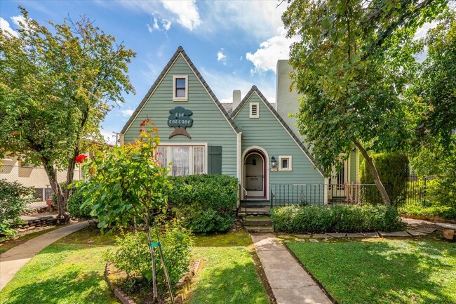

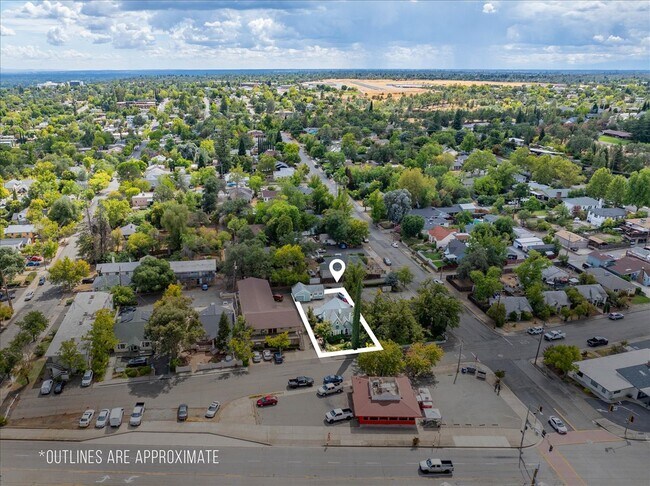
Property Detail
2469 Old Eureka Way
105-020-004-000
Shasta
Officebuilding
California
B and X Area of moderate flood hazard, usually the area between the limits of the 100-year and 500-year floods.
0.19 AC
2024
Redding/Chico
2025
Other Market Areas
010500
Redding, CA
1,787 SF
NEARBY LISTINGS FOR SALE OR LEASE
DEMOGRAPHICS near 2469 Old Eureka Way
1 mile
3 mile
5 mile
2025 Total Population
8,673
44,641
93,947
2030 Population
8,768
45,023
94,430
Pop Growth 2025-2030
+ 1.10%
+ 0.86%
+ 0.51%
Average Age
40
42
41
2025 Total Households
3,691
19,181
37,906
HH Growth 2025-2030
+ 1.14%
+ 0.83%
+ 0.51%
Median Household Inc
$62,876
$68,062
$74,824
Avg Household Size
2.20
2.20
2.40
2025 Avg HH Vehicles
2.00
2.00
2.00
Median Home Value
$421,745
$376,250
$372,945
Median Year Built
1972
1981
1982
Nearby Places
Map Layers
Map Styles
 Street
 Aerial
Transit
 Traffic
 Biking
Places
Listings with unknown addresses are not visible on the map
- Restaurants
- Banks
- Shops
- Fitness
- Groceries
PUBLIC TRANSPORTATION
COMMUTER RAIL
Drive
Walk
Distance
3 min
18 min
1.0 mi
AIRPORT
Redding Regional
Drive
Walk
Distance
Redding Regional
16 min
10.1 mi
Nearby Properties
Address
Land Use
TOTAL SIZE
Lot Size
Zoning
Address
Land Use
TOTAL SIZE
Lot Size
Zoning
15.20 AC
Address
Land Use
TOTAL SIZE
Lot Size
Zoning
2.60 AC
Address
Land Use
TOTAL SIZE
Lot Size
Zoning
71,579 SF
4.37 AC
Address
Land Use
TOTAL SIZE
Lot Size
Zoning
72,875 SF
3.93 AC
Address
Land Use
TOTAL SIZE
Lot Size
Zoning
31,365 SF
1.33 AC
Address
Land Use
TOTAL SIZE
Lot Size
Zoning
8.22 AC
Address
Land Use
TOTAL SIZE
Lot Size
Zoning
Address
Land Use
TOTAL SIZE
Lot Size
Zoning
89,098 SF
7.24 AC
Address
Land Use
TOTAL SIZE
Lot Size
Zoning
54,720 SF
2.53 AC
Address
Land Use
TOTAL SIZE
Lot Size
Zoning
21,089 SF
7 AC
Address
Land Use
TOTAL SIZE
Lot Size
Zoning
47,062 SF
4.80 AC
Address
Land Use
TOTAL SIZE
Lot Size
Zoning
108,208 SF
7.96 AC
Address
Land Use
TOTAL SIZE
Lot Size
Zoning
19,572 SF
5.94 AC
Address
Land Use
TOTAL SIZE
Lot Size
Zoning
61,754 SF
1.73 AC
Address
Land Use
TOTAL SIZE
Lot Size
Zoning
92,699 SF
5.91 AC
Address
Land Use
TOTAL SIZE
Lot Size
Zoning
10.27 AC
Address
Land Use
TOTAL SIZE
Lot Size
Zoning
104,740 SF
23.54 AC
Address
Land Use
TOTAL SIZE
Lot Size
Zoning
134,868 SF
0.57 AC
Address
Land Use
TOTAL SIZE
Lot Size
Zoning
2.42 AC
Address
Land Use
TOTAL SIZE
Lot Size
Zoning
2,821 SF
136.53 AC
Address
Land Use
TOTAL SIZE
Lot Size
Zoning
83,276 SF
3.02 AC
Address
Land Use
TOTAL SIZE
Lot Size
Zoning
16,320 SF
3.76 AC
Address
Land Use
TOTAL SIZE
Lot Size
Zoning
63,837 SF
0.69 AC
Address
Land Use
TOTAL SIZE
Lot Size
Zoning
46,705 SF
2 AC
Address
Land Use
TOTAL SIZE
Lot Size
Zoning
125,402 SF
20.61 AC
Address
Land Use
TOTAL SIZE
Lot Size
Zoning
39,290 SF
2.28 AC
Address
Land Use
TOTAL SIZE
Lot Size
Zoning
101,859 SF
Address
Land Use
TOTAL SIZE
Lot Size
Zoning
72,991 SF
4.25 AC
Address
Land Use
TOTAL SIZE
Lot Size
Zoning
2.39 AC
Address
Land Use
TOTAL SIZE
Lot Size
Zoning
4.20 AC
The World's #1 Commercial Real Estate Marketplace
Connect with us
© 2026 CoStar Group
The information above has been obtained from sources believed reliable. While we do not doubt its accuracy we have not verified it and make no guarantee, warranty or representation about it. It is your responsibility to independently confirm its accuracy and completeness. Any projections, opinions, assumptions, or estimates used are for example only and do not represent the current or future performance of the property. The value of this transaction to you depends on tax and other factors which should be evaluated by your tax, financial, and legal advisors. You and your advisors should conduct a careful, independent investigation of the property to determine to your satisfaction the suitability of the property for your needs.