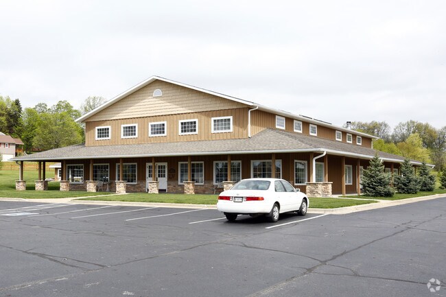
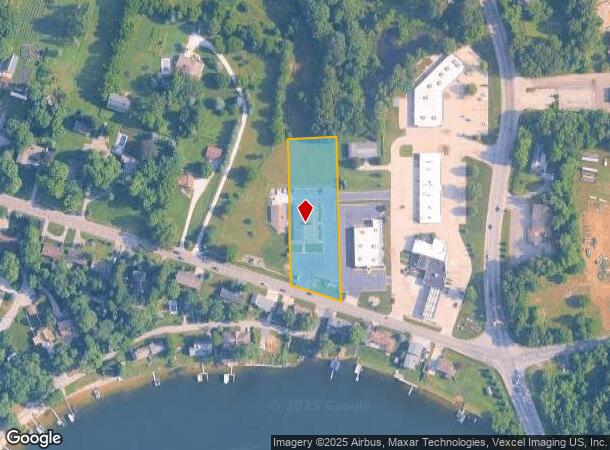
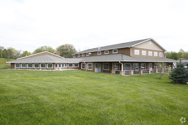
Property Record
247 W Johnson Rd, La Porte, IN 46350
NEARBY LISTINGS FOR SALE OR LEASE
-
-
-
-
-
No Photo
-
-
-
View all La Porte listings for sale on LoopNet.com
Property Detail
247 W Johnson Rd
46-06-22-326-013.000-042
04-06-22-326-013 IN NE COR FRL SW 1/4 S22 T37 R3 1.552 AC
Funeralhome
La Porte
X
Indiana
18091C0165D
1.55 AC
2024
South Bend/Elkhart
2025
Other Market Areas
042500
Michigan City-La Porte, IN
1,160 SF
DEMOGRAPHICS near 247 W Johnson Rd
1 Mile
3 Mile
5 Mile
2024 Total Population
2,051
16,918
36,213
2029 Population
2,037
16,779
35,719
Pop Growth 2024-2029
(0.68%)
(0.82%)
(1.36%)
Average Age
43
40
41
2024 Total Households
793
6,615
14,358
HH Growth 2024-2029
(0.63%)
(0.94%)
(1.55%)
Median Household Inc
$107,031
$56,674
$63,889
Avg Household Size
2.50
2.40
2.40
2024 Avg HH Vehicles
2.00
2.00
2.00
Median Home Value
$266,485
$182,357
$181,935
Median Year Built
1986
1956
1964
Nearby Places
Map Layers
Map Styles
 Street
 Aerial
- Restaurants
- Banks
- Shops
- Fitness
- Groceries
PUBLIC TRANSPORTATION
COMMUTER RAIL
Carroll Avenue (Michigan City) Station (South Shore Line - Northern Indiana Commuter Transportation District (South Shore Line))
DRIVE
WALK
Distance
Carroll Avenue (Michigan City) Station (South Shore Line - Northern Indiana Commuter Transportation District (South Shore Line))
15 min
9.0 mi
AIRPORT
South Bend International
DRIVE
WALK
Distance
South Bend International
47 min
31.3 mi
Nearby Properties
Address
Land Use
TOTAL SIZE
Lot Size
Zoning
Address
Land Use
TOTAL SIZE
Lot Size
Zoning
Address
Land Use
TOTAL SIZE
Lot Size
Zoning
38,110 SF
5.25 AC
Address
Land Use
TOTAL SIZE
Lot Size
Zoning
93,819 SF
3.72 AC
Address
Land Use
TOTAL SIZE
Lot Size
Zoning
150,000 SF
22.86 AC
Address
Land Use
TOTAL SIZE
Lot Size
Zoning
106,778 SF
15.78 AC
Address
Land Use
TOTAL SIZE
Lot Size
Zoning
86,550 SF
19.13 AC
Address
Land Use
TOTAL SIZE
Lot Size
Zoning
840 SF
18.96 AC
Address
Land Use
TOTAL SIZE
Lot Size
Zoning
63,583 SF
16.87 AC
Address
Land Use
TOTAL SIZE
Lot Size
Zoning
50,832 SF
14.26 AC
Address
Land Use
TOTAL SIZE
Lot Size
Zoning
9,940 SF
3.04 AC
Address
Land Use
TOTAL SIZE
Lot Size
Zoning
25,686 SF
2.68 AC
Address
Land Use
TOTAL SIZE
Lot Size
Zoning
51,910 SF
4.89 AC
Address
Land Use
TOTAL SIZE
Lot Size
Zoning
46,345 SF
37.29 AC
Address
Land Use
TOTAL SIZE
Lot Size
Zoning
26,586 SF
6.15 AC
Address
Land Use
TOTAL SIZE
Lot Size
Zoning
19,230 SF
2.32 AC
Address
Land Use
TOTAL SIZE
Lot Size
Zoning
12,586 SF
32.14 AC
Address
Land Use
TOTAL SIZE
Lot Size
Zoning
13,378 SF
0.78 AC
Address
Land Use
TOTAL SIZE
Lot Size
Zoning
7,217 SF
0.40 AC
LBCCN
Address
Land Use
TOTAL SIZE
Lot Size
Zoning
9,856 SF
1.28 AC
Address
Land Use
TOTAL SIZE
Lot Size
Zoning
6,615 SF
10 AC
Address
Land Use
TOTAL SIZE
Lot Size
Zoning
26,012 SF
3.77 AC
Address
Land Use
TOTAL SIZE
Lot Size
Zoning
69,350 SF
2 AC
Address
Land Use
TOTAL SIZE
Lot Size
Zoning
2,040 SF
4.69 AC
Address
Land Use
TOTAL SIZE
Lot Size
Zoning
2,500 SF
14 AC
Address
Land Use
TOTAL SIZE
Lot Size
Zoning
2,375 SF
4.67 AC
Address
Land Use
TOTAL SIZE
Lot Size
Zoning
1,922 SF
2.38 AC
Address
Land Use
TOTAL SIZE
Lot Size
Zoning
10,506 SF
2.23 AC
Address
Land Use
TOTAL SIZE
Lot Size
Zoning
95,276 SF
2.06 AC
Address
Land Use
TOTAL SIZE
Lot Size
Zoning
7,600 SF
7.50 AC
Address
Land Use
TOTAL SIZE
Lot Size
Zoning
45,018 SF
7.61 AC
The World's #1 Commercial Real Estate Marketplace
Connect with us
© 2026 CoStar Group
The information above has been obtained from sources believed reliable. While we do not doubt its accuracy we have not verified it and make no guarantee, warranty or representation about it. It is your responsibility to independently confirm its accuracy and completeness. Any projections, opinions, assumptions, or estimates used are for example only and do not represent the current or future performance of the property. The value of this transaction to you depends on tax and other factors which should be evaluated by your tax, financial, and legal advisors. You and your advisors should conduct a careful, independent investigation of the property to determine to your satisfaction the suitability of the property for your needs.