Property Record
247 Woodbound Rd, Rindge, NH 03461
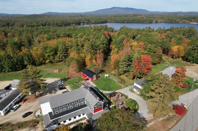
This Property Is For Sale
NEARBY LISTINGS FOR SALE OR LEASE
-
-
View all Rindge listings for sale on LoopNet.com
Property Detail
247 Woodbound Rd
RIND-000049-000021
Cheshire
Commercialnec
New Hampshire
X
21
33005C0467E
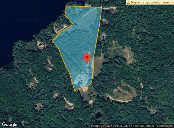
24.30 AC
2024
Manchester/New Hampshire South Area
2024
Other Market Areas
970600
Keene, NH
DEMOGRAPHICS near 247 Woodbound Rd
1 mile
3 mile
5 mile
2024 Total Population
1,027
7,426
12,896
2029 Population
1,080
7,812
13,557
Pop Growth 2024-2029
+ 5.16%
+ 5.20%
+ 5.13%
Average Age
37
40
41
2024 Total Households
318
2,686
4,761
HH Growth 2024-2029
+ 5.97%
+ 5.29%
+ 5.10%
Median Household Inc
$108,823
$75,548
$80,034
Avg Household Size
2.40
2.40
2.50
2024 Avg HH Vehicles
2.00
2.00
2.00
Median Home Value
$256,343
$240,774
$258,413
Median Year Built
1970
1974
1978
Nearby Places
Map Layers
Map Styles
 Street
 Aerial
Transit
 Traffic
 Biking
Places
Listings with unknown addresses are not visible on the map
- Restaurants
- Banks
- Shops
- Fitness
- Groceries
Nearby Properties
Address
Land Use
TOTAL SIZE
Lot Size
Zoning
Address
Land Use
TOTAL SIZE
Lot Size
Zoning
402 AC
COM
Address
Land Use
TOTAL SIZE
Lot Size
Zoning
COLLEG
Address
Land Use
TOTAL SIZE
Lot Size
Zoning
2,276 SF
146 AC
IND
Address
Land Use
TOTAL SIZE
Lot Size
Zoning
67,754 SF
28 AC
RB2
Address
Land Use
TOTAL SIZE
Lot Size
Zoning
4.36 AC
RA1
Address
Land Use
TOTAL SIZE
Lot Size
Zoning
171,426 SF
51.73 AC
IND
Address
Land Use
TOTAL SIZE
Lot Size
Zoning
91,174 SF
48.16 AC
COM
Address
Land Use
TOTAL SIZE
Lot Size
Zoning
56,886 SF
11 AC
VILLAG
Address
Land Use
TOTAL SIZE
Lot Size
Zoning
56,684 SF
3.51 AC
RA2
Address
Land Use
TOTAL SIZE
Lot Size
Zoning
1,860 SF
COLLEG
Address
Land Use
TOTAL SIZE
Lot Size
Zoning
Address
Land Use
TOTAL SIZE
Lot Size
Zoning
39,133 SF
10.88 AC
GB
Address
Land Use
TOTAL SIZE
Lot Size
Zoning
30,677 SF
5.14 AC
IND
Address
Land Use
TOTAL SIZE
Lot Size
Zoning
44.39 AC
Address
Land Use
TOTAL SIZE
Lot Size
Zoning
80,781 SF
8.88 AC
IND
Address
Land Use
TOTAL SIZE
Lot Size
Zoning
32,597 SF
5.17 AC
GB
Address
Land Use
TOTAL SIZE
Lot Size
Zoning
17,360 SF
4.01 AC
RA2
Address
Land Use
TOTAL SIZE
Lot Size
Zoning
4.96 AC
GATEWA
Address
Land Use
TOTAL SIZE
Lot Size
Zoning
104 AC
COM
Address
Land Use
TOTAL SIZE
Lot Size
Zoning
24.43 AC
COM
Address
Land Use
TOTAL SIZE
Lot Size
Zoning
16,096 SF
2.89 AC
GB
Address
Land Use
TOTAL SIZE
Lot Size
Zoning
28,141 SF
72.70 AC
IND
Address
Land Use
TOTAL SIZE
Lot Size
Zoning
5,888 SF
8.35 AC
RA2
Address
Land Use
TOTAL SIZE
Lot Size
Zoning
42.50 AC
RESIDE
Address
Land Use
TOTAL SIZE
Lot Size
Zoning
5,423 SF
17 AC
RURAL
Address
Land Use
TOTAL SIZE
Lot Size
Zoning
8,270 SF
7.24 AC
GATEWA
Address
Land Use
TOTAL SIZE
Lot Size
Zoning
9,628 SF
3.70 AC
R2
Address
Land Use
TOTAL SIZE
Lot Size
Zoning
5,799 SF
7 AC
RURAL
Address
Land Use
TOTAL SIZE
Lot Size
Zoning
5,667 SF
117.60 AC
RURAL
The World's #1 Commercial Real Estate Marketplace
Connect with us
© 2026 CoStar Group
The information above has been obtained from sources believed reliable. While we do not doubt its accuracy we have not verified it and make no guarantee, warranty or representation about it. It is your responsibility to independently confirm its accuracy and completeness. Any projections, opinions, assumptions, or estimates used are for example only and do not represent the current or future performance of the property. The value of this transaction to you depends on tax and other factors which should be evaluated by your tax, financial, and legal advisors. You and your advisors should conduct a careful, independent investigation of the property to determine to your satisfaction the suitability of the property for your needs.